Sugar House Park is a huge park located in Sugar House that features nice mountain views, a creek and a large pond. There are also several playgrounds and open play areas. There is also a connected side trail into Hidden Hollow, which is something I have been wanting to check out. Avalanche conditions are still pretty bad so I wanted to stay in the valley, but I wanted to do something new… so we ended up here. It was quite a bit more crowded that I would have liked, however there was plenty of space to distance.
I kept going back and forth as to weather I should post these together or separate, considering I enjoyed the hollow, but not the park loop so much. But, they are connected. So get your nature/history fix in the hollow, and the extra exercise along the loop.
Quick Details:
Length: 2.15 miles for both loops. Just the sugar House Park Loop is 1.4
Trail Type: Figure 8 or Loop if you skip the hollow
Difficulty: DR2. Fully paved, with mild elevation gain.
Elevation Gain: About 120 ft.
Restroom: Several. Not sure if they are open in winter though.
Dogs? Yes, leashed. Please clean up after your furry friends.
To Get Here:
Take i80 to the 13th east exit. Head north on 13th east to 2100 S. turn right. Take the first right into Sugar House Park. It’s a loop, so park anywhere. However I wanted to get to Hidden Hollow first so we parked near that (far west end).
The Trail:
Sugar House Pond.
The path to Hidden Hollow is at the far west point of the park, just to the right of the creek.
Fun red rock sculptures before heading under 13th east.
Oh fun. The red rocks are representing Echo Canyon which is upstream. It is also a hanging garden.
Heading under 13th east. Sadly there are a couple homeless camps in here. I don’t blame them at all. Anything to get out of the wind.
Hoodoos and the coal line, which we will learn about on the way back.
More hoodoos.
More of the faux canyon. Neat little sculpture.
SL County sign. Apparently, this was a highly littered dumping ground, and the plan was was to pave over it and make it a parking lot. School children can be thanked into saving and preserving it.
Parleys Creek.
A sugar beet sculpture.
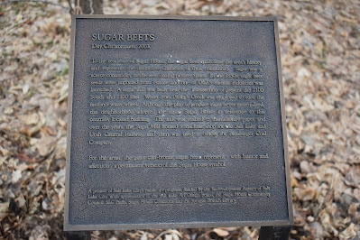
Well this is interesting. Sugar was scarce in the US in early pioneer times. In 1850 the first sugar beet seeds were imported. A sugar mill was constructed near what is now 2100 S and 1100 east. The city decided to name itself for this central prominent sugar factory (hence Sugar House). The sugar factory never really took off, and instead became a paper mill and then a machine shop.
The squirrels in this hollow are some of the biggest squirrels I have ever seen in Utah. Holy crap. I wonder if this is possibly a fox squirrel, which are not native but have been invading since 2011. Everything seems right, but that tail doesn’t seem bushy enough, so, maybe not.
Bridge over Parleys Creek.
Parleys Creek.
Fun park sign.
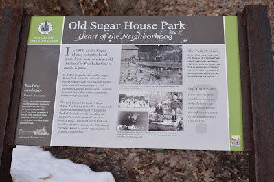
In the early 1900’s this was a park, in fact the Original Sugar House Park, that had a swimming pool and tennis courts. Eventually it came to disrepair and the citizens of Sugar House pretty much forgot about it. Construction debris were littered through the hollow. in 1980 the hollow halted further development and the plan was to pave over it to make a parking lot. Seriously, what is with early Utahans desire to bury creeks?
In 1989 students at Hawthorn Elementary took a fieldtrip, and discovered the hollow and the open area of Parleys Creek. They formed a group they called KOPE: Kids Organized to Protect our Environment. They uncovered the history and sought to restore the hollow. After considerable effort they managed to convince SL City Counsel to preserve the area as open space. Amazing! With help from the KOPE kids and adult volunteers, and generous donations they managed to clean up and restore the area. In 1999 the area was fully cleaned up and restored.
This is a more succinct account of how the hollow was saved from becoming a parking lot by kids.
Adjacent City Center. There is a nice tea bar in there called Tea Bar.
People and organizations the KOPE kids recognized.
Fish sculpture.
This sign talks about the original Sugar House Park, that this hollow was once a part of. It sounds like it was nice. It’s a shame it fell into disrepair. Which appears to have been due to the State Prison closing in 1951 which made room for Highland High and the new Sugar House Park.
Parleys Creek again.
Parleys Creek is the largest creek to come out of the Wasatch and join the Jordan River. Somewhere shortly west of here it was rerouted and goes into an underground canal where it joins emigration and Red Butte Creeks where all 3 join the Jordan River near 1300 south.
The creek.
There are 3 trails in the park. The south and middle trail are paved, the north trail is natural. I would have taken the natural path had I realized it, but in the moment it looked like it just dipped in and out for a minute. Meh. I kind of want to come back during high creek flow so, maybe next time.
How they measure changing stream depths.
“Don’t litter, there’s critters!” I love it.
The creek again.
Another squirrel. Now that I am seeing the tail better I am definitely leaning on this being a fox squirrel. But again, could be wrong.
Neat old stairs.
Higher up.
It’s a shame it is closed off, I would have liked to explore more. Anyway, these look super old, but appear to be attached to a modern building. I wonder if they saved part of an old demolished building?
Back to the faux Echo Canyon.
Some of the hanging gardens.
Hoodoos.
The little amphitheater on the other side of 13th east.
The black stripe represents a vein of coal. In pioneer times coal was coming into SLC from Parleys Canyon and elsewhere.
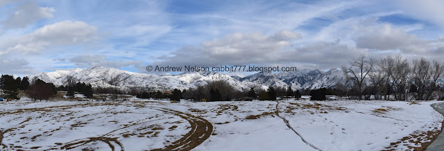
View of the mountains as we head back towards Sugar House Park.
Panoramic.
Where Parleys Creek leaves the park.
The pond again.
The road is one way, counterclockwise, and most people walking, jogging, etc, go the same way. I don’t know if that is the rule (didn’t see a sign or anything) or if most people are regulars and have learned what I did as an afterthought. For whatever reason I thought it would be better to go the other direction. I guess I thought I’d prefer to see what was coming. Looking back, I think it would have been better to go with the flow, than to try to swim against it.
The pond again.
Geese and seagulls.
Mountains.
Closer.
The loop is just the road that goes around the park, which was not very exciting.
Parleys Creek below.
More mountains.
I feel like I knew what kind of tree this was with the unusual splotchy colorful bark, but I can’t think of it for the life of me right now.
The park from the east end.
Parleys Creek.
Crossing over it.
There is a random dip further east that immediately swoops back in.
Back to the pond.
Geese.
The pond again.
Where Parleys Creek exits the pond.
The pond with the mountains.
Panoramic.
Geese.
Parleys Creek as it leaves the park and heads towards Hidden Hollow.
Hidden Hollow, while a bit short, was pretty, and offered a ton of fun historical information along the way, which I really enjoy. Plus I love to see that a natural creek area was saved from being buried. 8 out of 10 squirrels.
Sugar House Park was a good walk, with some great views of the mountains during part of it, but ultimately was not the most exciting trail. I might come back to walk around the pond and creek section, but yeah, the outer loop was pretty meh. 5 out of 10 squirrels.
As for difficulty, both are paved, with mild elevation gains. DR2.
Dogs are allowed, but must be leashed. Please clean up after your furry friends.
.jpg)


No comments:
Post a Comment