.jpg)
Big Cottonwood Regional Park - Holladay Lions Area is a large nature park located in Holladay. It features a lot of trails through some pretty wooded, and marsh areas, great views of the mountains, and best of all, foxes! Every time we have gone we have seen at least one fox. This is starting to become a yearly tradition for us.
There are four areas in Holladay/Millcreek that are all considered Big Cottonwood Regional Park. As I understand it, they will all be connected someday but right now it is a little confusing. Aside from this one there is Big Cottonwood Reginal Park - Creekside Park, Big Cottonwood Reginal Park - Big Cottonwood Area and lastly Big Cottonwood Reginal Park - Hillview Area (which is currently not accessible to the public).


Quick Details:
Length: We did a 2.2 mile loop de loop de loop today, but there are shorter options.
Trail Type: Loop de loop de loop, Loop and loop de loop options.
Difficulty: DR3. It’s fairly flat with some paved, and some hard packed earth.
Elevation Gain: About 40 feet.
Restroom: Yes, however I did not check to see if it is open in winter.
Dogs? Yes, leashed. Please clean up after your furry friends.
Other Info:
To Get Here:
Take i15 to 4500 so. Head east to 13th east go right. Go about 6/10s of a mile and turn left on Murray Holliday Blvd. You can turn a little earlier, but it requires another left turn. Anyway, go about 4/10ths of a mile and turn left on 1590 east. You can go about .15 of a mile and park by the restroom, or go to the end of 1590 east.

As we were heading east I started to wonder if maybe I should have planned something above the inversion today (Passenger Seat Photography (PSP)).
The Trail:

As usual, my first idea was to B-Line it to the fox viewing area.

Well this is new. I wonder if they had a problem this year.

Even in the dead of winter, it is a very pretty park.

Marsh area.

Mount Olympus.

The remaining viewpoint. Unfortunately, people took it upon themselves to feed the foxes that reside on this private farm. Sadly, some of the stuff they were feeding the foxes was poisonous to the horses that live here too. So they have installed a board fence for most of the way, They were nice enough to leave this viewing area open for us, at least for now. You can help keep this available for all of us by not feeding the foxes. Honestly, you are doing more harm than good anyway. So just, don’t.

Sign reiterating that.
Well, no luck with the foxes at the moment so we decided to walk around the back loop and maybe come back.
I call it the back loop because well, it is behind the main loop from the parking lot, but I guess really it is the east loop.

Cute little painted sign showing what to do with dog poop.

And some other signs as well. I guess there have been issues here. As far a dog friendly areas I have been to, I didn’t notice much of a problem today. Perhaps all the signs are working?

Mount Olympus again.

Approaching the back end of the park.

The split for the back loop.

The trail is a little less defined, but still easy to follow.


There are some urban farms through here.

Mount Olympus again.

A neat artistic double spiral. I am not sure if that is the right term for this, but it has two paths, spiraled together. Here is the west path, that appears to be the main path.

Closer. I think it is pretty neat honestly. Not quite as neat as The Spiral Jetty but still neat.

I decided to hop over to it and walk around the spiral. Mostly to confirm that it was indeed a double as I suspected.

It sure didn’t take long for me to confirm it! Here is the second paths entrance into the spiral.

Looking back towards the center.
What makes this a little different than a regular spiral is that because it is a double, I can keep walking to and from the center without turning around. So it is different than the random spirals we have found in places like Ladyfinger Point and Alien Tower.

The east entrance again.

The west entrance has been lined with fallen leaves.
.jpg)
Panoramic.

Mount Olympus again. It still kind of boggles my mind that this isn’t Twin Peaks. I get it is the most prominent mountain in the valley, so Olympus makes sense, but wow, those are some twin ass peaks! Twin Peaks was given to the twin peaks just to the south of this.

Heading back west.

The spiral from the other side.

I thought this sign might offer a little more insight to the spiral, but it is just some artwork from the charter school that runs the farm here.

The west entrance to the spiral. I didn't bother going back in since I already explored the main spiral.

More farm.

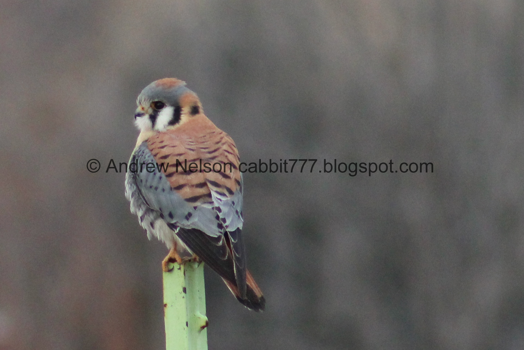
Well hello there cutey!!! It has been a good minute since we have had a good kestrel sighting. Kestrels are our smallest, and prettiest murder birds.

Look at that adorable little face! These shots are with my telephoto lens. I have learned, very slowly I might add, different bird behaviors and when to maybe take a second to get a closer look. Sometimes it’s just a robin, sometimes it’s a kestrel. However as I said, I am slowly learning when to take the effort to investigate further.

Ahhh! I caught a good strike! I don’t think it caught anything, but it was a good strike.
Back to the post. I think I like this shot best.

Man, I just love these guys!

Can I take it home?

Getting ready to take off.

Okay, BYE!!!! Thanks for posing nice for me for a minute!

Mount Olympus again.

“We are growing vegetables for families in need. Please do not pick”

Back to the main park loop.

Marsh.

Continuing along the bend.

Gopher holes.

Approaching the playground and restrooms on the west side of the park.

Marsh.

With Mount Olympus.
.jpg)
Panoramic.

Frozen pond. As I understand it, phase one of improving the parks will include removing the invasive plants and expanding the pond.

Frozen pond and Mount Olympus.

Heading back through the middle path back to the east end.

I don’t know who created these fun little poems about picking up after your dogs, but I really just love them, and have seen them in several of my favorite parks.

The other side has another fun one.

More pretty trees.

Clearing.

Back to the viewing area.

The horses decided to make an appearance. This is a first.

Fox snoozin.

And hello! We have a handsome fella coming in.

Coming closer.

So handsome.


quick little action sequence.

I really just love these guys!

I didn’t realize it until after I snapped the picture, but uh, caught him or her taking a wee.


Back to doing foxy things.

Hello friend!
I totally want to snuggle a fox, but first of all, I am not sure if it is even legal to own one in Utah. and second of all, as I understand it, their urine is absolutely awful. Like so bad it is used as a deterrent. I guess I can settle for enjoying them from a distance.

Walking past their sleepy friend.

Back into the brush. Bye!!!


The farms horses decided to come pay us a visit. Hello guys!

Our sleepy fox friend appears to have woken up.


More horse friends.

Saying hello. I know horses are really social creatures, but I guess I have seen too many videos of people being bitten by them, and it looks like it really hurts so as much as I want to give him some loves, I also just don’t. But hey, he’s a cutey.

Of course after I switched back to my regular lens sleepyhead decided to get up and roam around. Sigh.

Well, we had our fun with the foxes, we decided to do the north loop again and give some more time towards dusk to see if maybe they would be more active then.

This loop is around what appears to be storm water drainage marshes.

Trees around a storm water drain.

The marsh area from the north end.

Cute little, old truck. Seriously, it is so cute!

Outlet.

Mount Olympus.
.jpg)
Panoramic. Lets see, Grandview Peak, Grandeur Peak, Mount Olympus, Twin Peaks, Mount Jordan.

Mount Olympus.

I think this is Mill Creek Canyon.
.jpg)
Another panoramic.

The trail is a little faint around the north loop, but not so bad.

Mount Olympus again.

I am generally a big advocate for staying on established trails. However, eh, its a park, and I wanted to B line to the fox viewing area again. So we just went across the grass here. I figure grass fields in parks are generally fair use.

The wetland in the middle of the park.
Well, no luck at the main viewpoint, so we decided to do another loop.

This loop is a thinner trail that takes you through the woods.

Little tunnel into the woods.

Oh! Hello Mr. fox friend. Please stay put while I put on the telephoto lens.
Wow! I think this is the shot of the day.


Oh, don’t run away!


Cute little guy.

He stopped for a second to look at us.

So cute!

Nope. Back to running away.

Back into the foliage.
I feel bad, there was another shutterbug at the viewing area with us earlier that we had gotten a little chummy with. Her partner was here and trying to call her over (they had a cute “bird” call way of alerting/locating each other it seemed). But by the time she showed up the fox had disappeared into the woods again. At least she saw the sighting that I did earlier so she should have gotten some good shots today as well. Also, she seemed more patient than I am so they probably stuck around longer and had more sightings than we did. But I do feel bad that she missed this one.
Well, we decided to keep going around the loop.

Squirrel!

I didn’t want to switch back to the regular lens in case we saw another fox, so not a lot of great pictures through here.

Back to the main loop, with a view of Mount Olympus.

Big Cottonwood Regional Park Restoration Plan Phase One. They plan to expand the pond and wetland. Remove non native plants and plant native plants.

Heading back to the parking lot along the main middle trail.

Gopher holes.

Little side path that goes through the woods. Last time we tried to do this it was dark. I don’t think it is much longer than the main path to get back to the parking lot.

Little bridge.

Little stream bed.

Forest.

Back to the parking lot.
Well, this is the first time we have done pretty much all of the random loops in the park, aside from the sports fields. Considering each loop individually is a little over a mile, its weird that pretty much the whole thing is only 2.2 miles. But I guess it makes sense with how much they overlap along the main trail. There are definitely people enjoying the park, but nothing too crazy. Of course my absolute favorite part is the foxes, and I think we had a decent day for them today too. Plus a kestrel! I think today was a 10 for 10 day.
As for difficulty, it is generally pretty flat, some paved, and some like paved. DR3.
Dogs are allowed, leashed. Please clean up after your furry friends.
