.jpg)
Dimple Dell Park is a huge multi use trail system located in Sandy. It offers over 15 miles of trails to explore. This section of the park offers some nice mixed forest, and some desert scenery, as well as nice views of the mountains. The trails range from paved, to woodchip lined, to natural surface. We’ve done this part of the park before, but today we used some different trails.
Quick Details:
Length: We did about a 4.3 mile loop today, but that could vary depending on what trails you use.
Trail Type: Loop, out and back, or connector.
Difficulty: DR3. This is pretty easy going.
Elevation Gain: About about 246 feet.
Restroom: Yes, but I believe they are closed in the winter (sounds like they are planning to fix that though). There are a few nearby gas stations, or grocery stores too.
Dogs? Yes, leashed.
Other Info: The way we did it starts at the top, and returns uphill. This can prove to be a challenge if you are not used to going uphill. If you are not sure you can handle that, use the Porter Rockwell Trailhead off of 300 east.
To Get Here:
Take 106th South to 13th east, Go south for about 1200 feet then turn right*. Go another 300 feet and you will see the Wrangler TH on the right.
*if you pass Smiths on 13th East, you went to far, but go ahead and turn into their parking lot and head south it’ll get there too.
The Trail:

Trailhead Kiosk.

Little picnic area just below the parking lot.

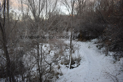
Heading down into the gully along the Dimple Dell Trail.


The tunnel under 13th east.

View of the gully again.

Fun clouds.


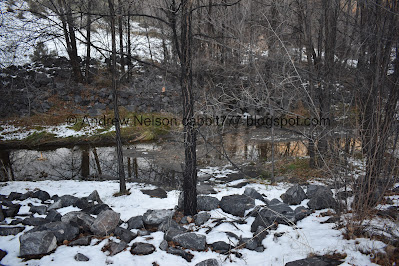
Hey there is some water in the creek bed.

The Dimple Dell Trail goes across the creek. We ended up on a smaller, unnamed side trail staying on the north side of the creek.

The creek again.

Lovely forest.

A drainage ditch adding to the creek.

Forest.

Through the bushes.

The creek again.

Then, all the water is just gone. Diverted somewhere.

The lower gully.

Following the creek bed of Dry Creek.

This part of the trail is right next to the creek bed.

The creek again.

Little cave. We have climbed up there before, but it is steep, and muddy right now. Plus, its only a couple feet deep, so not terribly exciting, so we decided we didn’t need to risk it.

Looking back towards the mountains.

There is some kind of utility you will go by. Power plant? Water treatment plant? I’m not sure.

We were forced to use the creek bed as the trail for a second. But, as you can see the trail picks back up on the right.

Old road and creek crossing leading to the utility.
I noticed a trail off of the road that would keep us on the north side of the creek. Again, I don’t think we are on an official, named trail.

The gully again.

The creek bed.

Again.

More fun clouds.

More creek bed.
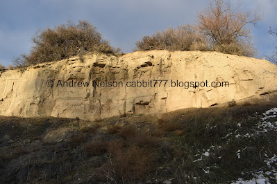
I love the sand cliffs seen along this gully.

Wait a minute…. was that here before? I have a weird kind of, possibly even photographic memory of trails we have done and I honestly do not remember this. Not to say my memory is perfect but… yeah.

Clouds.

It doesn’t look particularly new so I was starting to think maybe I just forgot…
Thank goodness for google maps and its historical function.

The satellite map does not appear to show a bridge, but does show a new White City Trail crossing through here.

Here is the current street view from the south. You can see the bridge back there.

Here it is from June 2019. So sometime between then and now this bridge was put in and the White City Trail came through here. Might have to check that one out sometime.
So, I am not crazy! It is new.

Anyway, back to the trail.

Natural archway.

Again the trail put us in the creek bed.
The creek has water again.

Back on the Dimple Dell Trail, heading under 7th east.

The creek is dry again haha. How many diversions are there along this thing?
There is a a trail that will bring you back to the north side of the creek here, for some reason we decided to stay on the Dimple Dell Trail for the rest of the way. It only put us on the south side for about 3/10ths of a mile anyway.


Forest.

Where the Dimple Dell Trail crosses back over to the north side.

Looking back at the mountains.

The gully below.

Lots of trees through here.

The creek below.


More forest.

At just over 2 miles we reached the end at 3rd east. I didn’t bother climbing the hill to see the dog park today.

We decided to return on the south side of the creek. First using this connector trail.

Through the woods.


The creek.

Mountains and Little Cottonwood Canyon.

The west bridge.
We took this short connector trail to stay on the south side.

Forest.

The middle bridge.

Now we are back on the Dimple Dell Trail.

Interesting family tree.

Forest.

Heading under 7th east again.

I think it is stupid that cities have to install these things to prevent stupid people from hurting themselves and suing.

More forest.


Back to the new pedestrian bridge.

The mountains.

I really just love seeing the mountains covered in snow. I was feeling like it seemed like a long time since we have seen snow and well, I was not off. The weather said this was the 4th longest streak between accumulating snowstorms in SLC at 259 days between storms. The 5th latest snow of the season. Wow.

More fun sandy cliffs.

The creek again.

We took a wrong turn and ended up following the maintenance road back down towards the utility.

So we made the creek bed our trail until we found a trail back up.

Working our way back up, I startled some bird out of this branch that I didn’t notice until I startled it. Judging by the amount of feathers fluttering about, my guess is I inadvertently disturbed a hawk with a meal. I can’t come up with any other reason a bird would shed so many feathers. Sorry guy! I didn’t see you.

Now I think we are on the Dimple Dell Loop Trail.

Moody skies.


I think we took another wrong turn and some how ended up back down at the creek.

Another natural archway.

Looking downstream.

We had to make our way to the north side of the creek again. So we crossed over the far east bridge to go back to the south side which has another unnamed trail back up to 13th east.
Disclaimer: I do not recommend using this trail in winter. It was a bit… dicey. Looking back, I would have rather continued back up using the Dimple Dell Trail.

View from the bridge.

Thin, icy trail right next to the creek. Yeah, not so fun.

Some hill climbing.
I didn’t get a picture of it, but the trail back down was quite steep and slick.

Forest.

Pipe under 13th east.

The creek again.

Now there is just the steep climb up to the top of the gully.

The valley below.


Tunnel under 13th east.

Mountains again.

Back to the parking lot.
I really enjoyed our adventure today. Even with the few missteps and following unofficial trails that were a little sketchy. It was not terribly busy and I enjoyed the mountain views. 8 out of 10 squirrels.
As for difficulty, I would still rate it all as a DR3. The sketchy trail can be avoided. But otherwise it was pretty easy going today.
Dogs are allowed, but should remain leashed at all times.

No comments:
Post a Comment