.jpg)
Dripping Rock is an amazing little.. seep waterfall thingy located in Spanish Fork. The trail features the waterfalls, a river, and, what really sold this trail for me, a suspension bridge! I have had this little trail system on my list for a few years now, always meaning to do it in early spring but it just hasn’t happened yet. Well, we had a crazy, crazy cool down this weekend so I thought today was the day! I added a couple other nearby things I was interested in to make the drive more worth it.


Quick Details:
Length: It was about a mile out and back, plus whatever exploring you do. We did about 1.6 miles out and back.
Trail Type: Out and back.
Difficulty: The main path is fairly flat and paved DR2. To get down to the dripping rick is a little scramble, DR3.
Elevation Gain: About 160 feet.
Restroom: No.
Dogs? Unconfirmed via signage, but there are dog waste bags so I assume yes. Please clean up after your furry friends.
Other Info:
To Get Here:
Take i15 to US6 in Spanish Fork and head east for 4.4 miles. Turn Right on Power House Road. Go about 3/10ths of a mile and turn left into the trailhead parking lot, across the street from the Spanish Oaks Golf Course. There is additional parking just to the west on River Bottoms Road.
Follow the trail east.

As we make our way south we passed by Steep Mountain (Passenger Seat Photography (PSP)).

Mountains above Utah Valley (PSP).

Well, that is new, at least to me (PSP). It appears to be a pedestrian bridge over the freeway for UVU. This looks quite a bit longer than the pedestrian bridge over i215 on Parleys Trail.

I’m about to pull over and throw the One Ring to Rule Them All into the Sew Sweet Minky Designs (apparently not the same as Minky Couture) headquarters (PSP). Holy Eye of Sauron design, Batman.

Heading through Spanish Fork on Highway 6 (PSP).

Spanish Fork Canyon and the windfarm below it (PSP). Dang it has been a few years since we were by here. I am pretty sure the last time was our random trip to Avon, Colorado 10 years ago. Dang, that has been a minute!

Closer (PSP).
The guide I was using said to park across from The Oaks at Spanish Fork Golf Course. Neither of us were at all familiar with the area and didn’t really know what to do. We saw the parking lot for the golf course said private parking, so we knew we couldn’t park there… so we turned around and I saw the parking lot I was pretty sure we were supposed to be in but then as we turned down River Bottoms Road to turn around again I noticed another parking lot. We decided to see if this parking lot was what we needed or not. It ended up working out for us, but the other lot would have been just a smidge shorter.
The better parking lot is located here:
The parking lot we used is here:
The Trail:

Map at the trailhead kiosk. Again, I am not at all familiar with the area and I was having a hard time making heads or tails of this. Seriously a little “you are here” dot would have helped out a whole lot. I ended up having to pull out the phone and use Google Maps to help us out. It pointed us to the left here, which was eastish so that made sense.

Crossing over Spanish Fork AKA Spanish Fork River. The actual name of the river is just Spanish Fork, but most people tend to call it the Spanish Fork River. I think it kind of just naturally happened to differentiate it from the city named after it.

Tunnel under Power House Road. This led to the parking lot we should have used. but really where we parked only added about 300 feet of walking, so not a big deal.

Okay, phew. This sign confirmed we were on the right path and it is super short.

Beautiful canyon.

It is super green in here.

Continuing the climb.

Well, what do we have here?

Next to this rock wall there appears to be a random painted rock community project like Rockwell The Trail Snake. This is not quite a snake, and more just a bunch of painted rocks between the trail and the rock wall.
I am torn on these random community art projects. I think they can be fun, I love seeing all of the little individual art pieces, but at the same time, they can get out of hand very quickly, as Rockwell did. So… meh.

“It’s JUST a phase”. Cute.

Spanish Fork below.

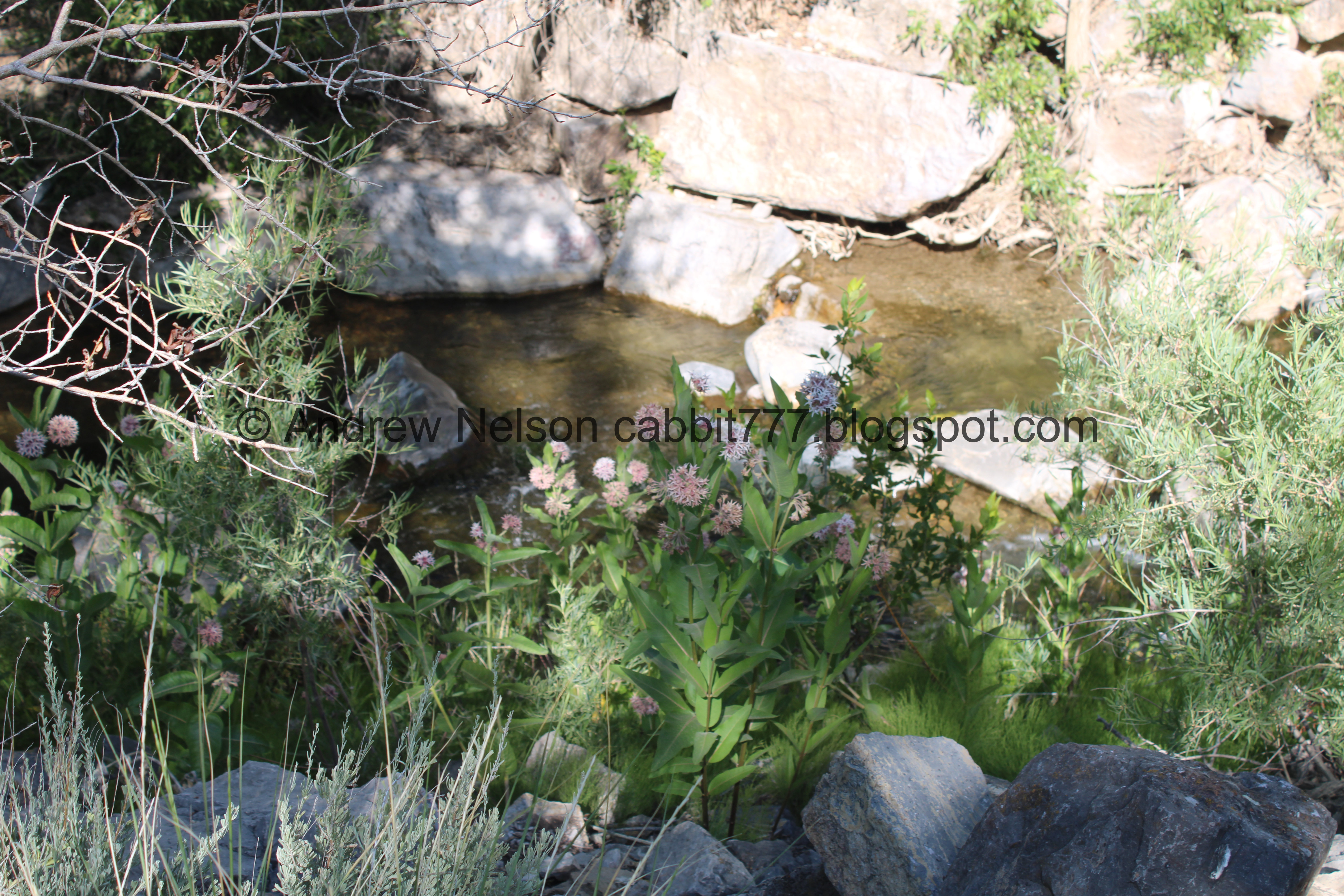
There is a larger dripping area back there that we can’t see right now. We might have to come back sometime when the foliage isn’t so thick.

“Help”

“Ask for help”

They are right next to each other. So that is kind of fun and silly.

Continuing along.

Fun watermelon slice.

For a paved city trail, it is really quite pretty.

Fun haunted house rock.

Continuing along.

Milkweed.

One of the windmills at the mouth of Spanish Fork Canyon popped into view. That was a bit of a surprise!

Cute butterfly and beetle. They look like stencils. My first thought was ‘that is cheating’ but then I was just like.. meh. You do you.

Neat leaf.

Catwoman is my favorite! I was happy to see her.

Continuing along.

At about 4/10ths of a mile we have reached dripping rock. Wow! That is pretty neat! We decided we would explore it more on the way back.

Heart shaped rock.

Someone made a mermaid. This is what I love about random community art projects! That is super creative and super cute!

Continuing along.

The end of the random community art project.

779. We found a few things this could mean.

Then we reached the main Dripping Rock. WOW!!! That is super neat! But again, we decided we would check it out on the way back.

Continuing up.

The river again.

Mile Marker 5. I might need to come back and do the whole thing one day.

The first bridge.

It is your standard modern truss bridge.

Neat old spillway.

Closer.

Downstream.

Upstream. The spillway has excavated quite the little pool. Look how clear the water is though! Wow!

Continuing along.

We made it to the Suspension Bridge. This is only the 5th Suspension Bridge I have found so far.

I did not find an information plaque, but here are the rules.

According to google maps it is called Lars Legacy.
I am not having a ton of luck figuring out why it is called that or who it is named for. I did find a person from Spanish Fork named Lars Lester Larsen who died in World War One. So that seems likely. But again, unconfirmed so I won’t go into detail about him. It would appear that the city is trying to preserve his house though.

Downstream.

Again.

Random rock dam.

Upstream.

From the other side.

Using Google Maps again, the main span is about 112 feet. 163 feet with the angled ends. And I would guess about 15 to 20 feet up.
Unfortunately not every neat bridge has an informative plaque like the Bear Canyon Suspension Bridge does. So, I have no idea how old it is, but it doesn't look very old. Messing around on Google Earth it looks like it was built somewhere between 2019 and 2020. Wow, that is not very old at all.

I am not sure how tall the support beams are. Maybe another 25 feet.

Oh, we can see the Escalante Cross from here! That is another random trail I have had on my list for a minute. We did not get to all 4 things I had planned on doing while down here so I guess I can add that on to that sometime.

Back to the neat bridge.

If it is not already obvious, I love me a good bridge. I am particularly fond of suspension bridges.

Again.

It really is a handsome fella.

Again.

The river again.


Back on the other side.

I just love it! Super neat bridge.

You can see the windmills again.

The river again.

The little rock dam.

Upstream again.

Support cables.
Alright. I had my fun but we should head back.
From what I can tell, if you keep going up it leads to a reservoir, and then just a bit further up Spanish Fork Canyon.

A bunch of pretty white butterflies.

Little closer.

The lower bridge.

The deep pool below the old spillway.

Closer.
Found a big patch of milkweed.

The river again.

If you look really closely you can see a couple of small drips.

Back down to Dripping Rock.
I was too excited at the pretty display of nature that I did not get a shot of the somewhat steep decent down to the river level. But, it wasn’t too bad, and I wasn’t really worried about being able to get back up.

But look how neat this is! I uh… I took a lot of pictures.

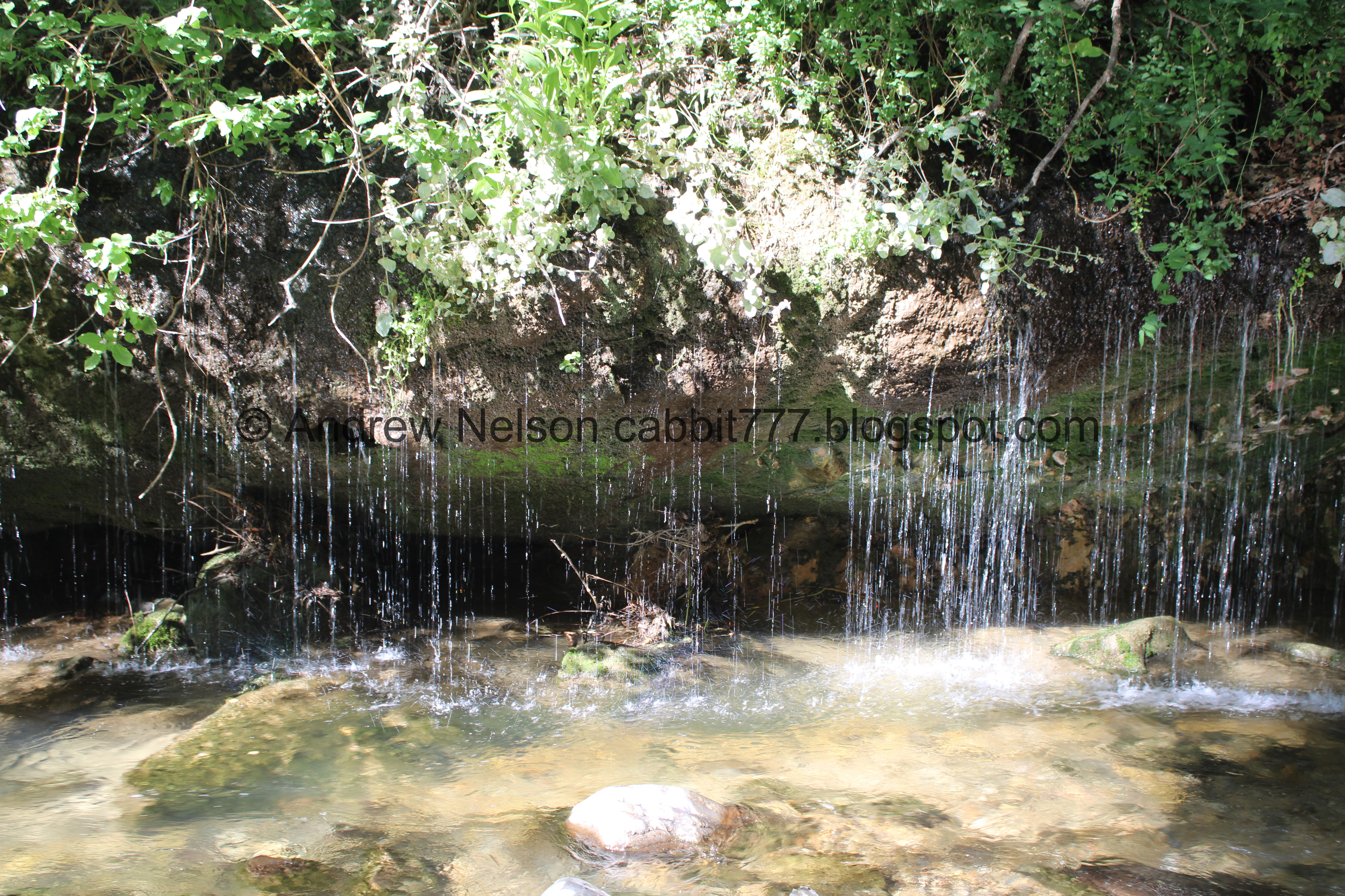
There is no informative plaque, and I certainly don’t know what the hell I am talking about, but it appears there is a large amount of water and a hard layer below a less hard layer that the water is seeping through in a particularly wide swath.

Some larger springs downstream.


This is way more exciting than I thought it might be!

Some smaller streams upstream and some neat colors.

The streams and the river.


There are 2 major "curtains". This is the wider of the 2.

Both curtains and a smaller one in between.
.jpg)
Looking upstream.

Super neat.

Part of an old pipe.
Eventually I decided that I would like to wade out to them. Yes. Me. I took my shoes off and got in the river. I very very rarely do that. LOL.
There were signs warning that the river is prone to sudden flooding and to be be cautious, but as far as I know wading is still allowed. Just, you know, do so at your own risk.

Well this shot alone made it worth it!

This is probably the coolest natural thing we have seen in a minute!

Longer exposure.

Upstream again.

Landis took a few shots of me wading in the water, since it doesn’t happen often haha. For the most part it was fine. The water wasn’t too cold and it mostly wasn’t too deep. I just wish I had thought ahead and worn some kind of water shoe, cause the rocks were a bit sharp and slippery at the same time.
But you know, if you are going to randomly wade in the water, I recommend Darn Tough socks. I like them for a million other reasons, but they really made 'putting socks and shoes on still wet feet because you didn’t bring a towel either' a whole lot less awful.

One of the curtains and the river.


Detail.

Pretty curtain. I thought about going in for a quick shower, but it wasn’t warm enough to be wet for a while, which is why we were here in the first place haha.

Longer exposure.

So pretty.

Longer exposure.

More dripping downstream.

A gorgeous curtain.
Ooh, I took a quick video.

The wider curtain.

I was working up the courage to head downstream to the bigger falls. There was another family wading and it looked a bit deeper down there.
Damn nature, you pretty.

The more thin curtain again. Yes, I am jumping all over the place. IT’S JUST SO PRETTY!!!!

The wide curtain.

Getting closer to the bigger stream.

Again.

Better viewpoint.

Longer exposure.

More drippage downstream.

Upstream.

With the river.

Back to the big stream.

Closer.

Even closer.

Downstream.

One last look before I wade back upstream.

More drippage.

While I was putting my shoes back on we noticed these pretty flowers that we have never seen before.

They are chatterboxes or stream orchids, in the orchid family. Hooray, we found another wild orchid, and an actually significantly sized one. The only other orchid I have found in Utah is the white bog orchid which is pretty, but it is wee.


I mean, they almost look like the orchids you can buy at a store. I have never had very good luck keeping those suckers alive. I absolutely love them, I just can’t keep em alive.

There is a huge patch of them here.
I wonder if I can find them closer to home.

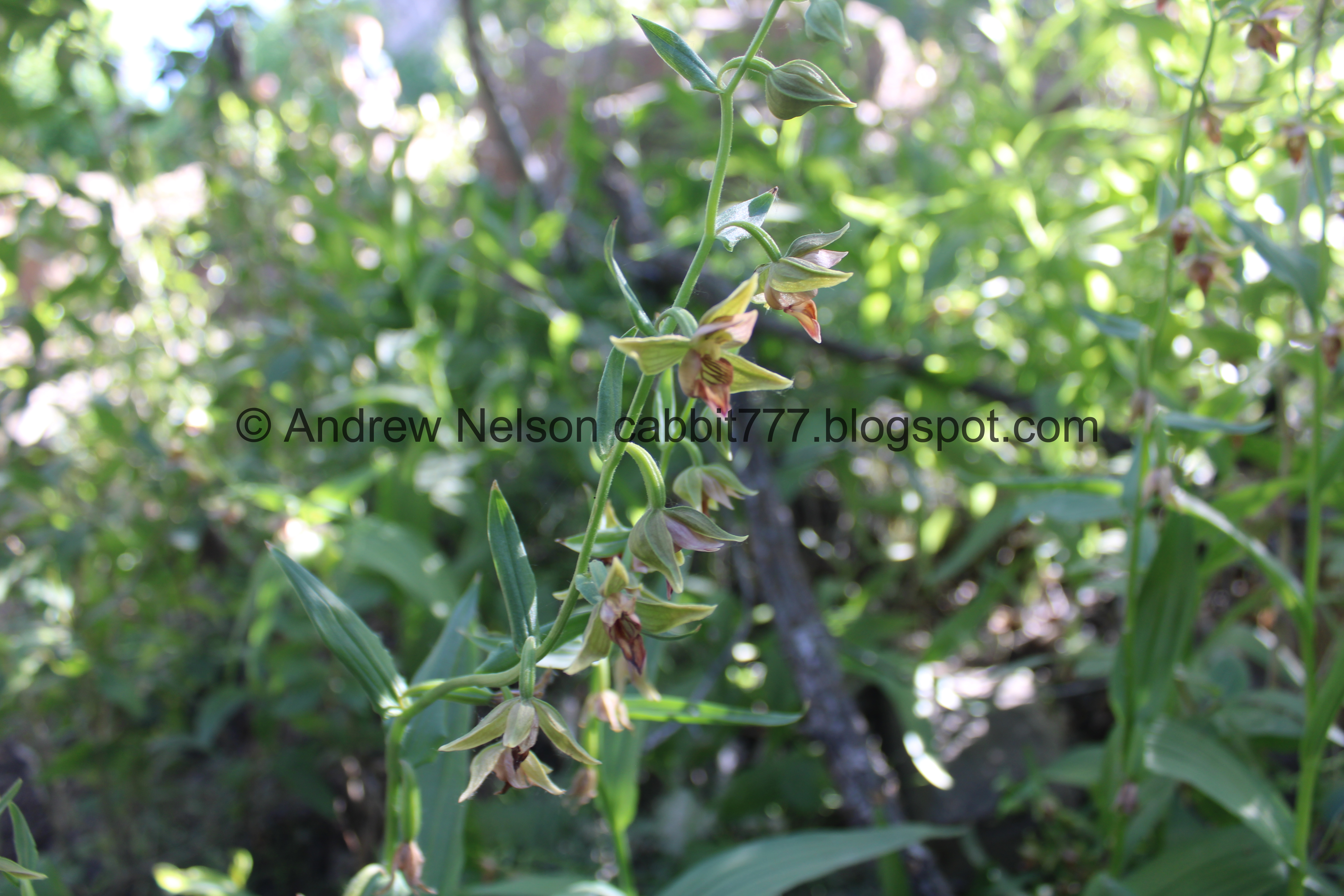
Such a gorgeous flower!
Well today has been just full of wonders, and we are just getting started!

Final look at the dripping rock.

Downstream.

Upstream.
Okay. I finally managed to peel myself away. Wow this was way, way more exciting than I thought it would be!

Heading back down, the trail is suddenly very busy! Where did all these people come from?

The river again.

Precarious boulder above.

Back to the painted stones, I found a Minion.

My Neighbor Totoro. I didn’t notice it at the time, but it looks like there are at least 4 rocks representing that movie.

The river.

Thistle.

Continuing down.

Mountains.

The crossing next to Power House Road after we crossed underneath it.

The Escalante Cross from the lower parking lot.

Digital crop. You don’t see a lot of crosses in Utah (LD$ folk don’t “celebrate” it) so I think it is neat.
Our next destination took us further south. I was a little surprised it didn’t take us back to Highway 6.

Power House Road (PSP). We both wondered what the power house was that the road was named after.

Terrible shot but, this is the Strawberry Water Users Association Power Plant (PSP). I am guessing this might be the power house.

We saw some turkey vultures doing their thing (PSP).
Some asshat was tailgating us so Landis pulled over. I decided to take the opportunity to get some better images of the vultures with the telephoto lens.

Wow!


Turkey vultures are pretty easy to identify with the obvious tiny and bald head, but if you are not that close, the 2 toned wings on the underside are another super useful identifying feature.


Just having fun with the vulture friends.

Super neat.

They were really putting on a show.

I didn’t notice these guys in the trees until now. I was following the flying one. How many can you find?

Caught him going in for a landing, and again did not notice the others until now.

I think this is the best shot of one of their faces I have gotten so far.

Again.

Again.

Preening.

The cliffs above.

Back to a flying one and probably the shot of the day! Wow!

Eventually they started flying away. Landis counted 8 or 9. I don’t think we have seen that many in a group before.
Well, I think I am going to split up my post here, stay tuned for my next post: Salem Lake.
This short adventure had it all! A much bigger than anticipated display of nature, an amazing bridge, pretty flowers including a really neat new one for us, and a great bird sighting! I am actually kind of glad we didn’t get to it earlier in the year, because I probably would not have gotten close to them. It was a perfect random cool weather day in summer adventure! I kind of wanna give it 11 squirrels! But, I don’t have a label for that, so 10 it is.
As for difficulty, you can see dripping rock and the bridge from the paved trail, so DR2. But to really see them you have to scramble down a pretty steep hillside. DR3.


Dogs: Yes, leashed. Please clean up after your furry friends.

No comments:
Post a Comment