.jpg)
The Jordan River Parkway is a 45.3 mile long trail that follows the Jordan River from it's source, Utah Lake, all the way through Salt Lake County to the north border where the trail connects to the Legacy Parkway Trail. I am still slowly working myself along it, but I thought I would start this article now and slowly update it as I complete more sections. So, this is currently an incomplete list.
April 2022
I am so excited to announce I have finally completed the trail! I kind of randomly started doing the north end about 4 years ago, back when I lived in Davis County. At the time I never thought I would do the whole thing. Then I moved to Salt Lake County, and we had a pandemic, and suddenly it was a goal in 2020. I think 2 years is a reasonable goal to complete the whole thing.
2 Counties (crossing into a 3rd when joining the Legacy Parkway), 15 cities and some unincorporated areas. 90.6+ miles, considering I did each trail as an out and back or a loop (and revisited a few spots and overlapped in others). I split the long trail into 30 sections, mostly around 4 miles out and back, some shorter, some longer.
I think there are a few spots I might want to revisit, due to detours, or some other reasons. However it really feels great to say I completely such a lofty goal. And honestly, exploring the valley along the river, at a leisurely walk was really something! I highly recommend it.
Quick Details:
Length: 45.3 Miles one way.
Trail Type: Mostly connecter and/or out and back. Some loops.
Difficulty: It is paved, and mostly flat. Overall a DR2
Elevation Gain: Overall 692 feet.
Restroom: Plenty.
Dogs? Yes, Leashed.
Other Info: You can see an official trail map here.
To Get Here:
Depends on which section you want to do. See each sections overview.
The Trail:
Even though I started at the north end, I think it makes sense to go in order of the mile markers. So we will start at Utah Lake. This means a lot of the segments (mostly the south half) will be presented here as south to north, when I actually did them north to south. It makes sense in my head to do it this way, so I hope it makes sense here too.
Use the South Map for these segments.
Inlet Park to Pioneer Crossing

The final section along The Jordan River Parkway was pretty nice. It strays away from the river for much of the way, however it is currently very wild. I say currently because Saratoga Springs and Lehi are both growing very quickly, so it could be developed eventually. Right now though, it is quite lovely. I started from the other direction today because there isn’t really anywhere to park at where I left of last week. This portion will complete the south half of the trail! Which was my goal to do before it got too warm. Come fall I plan to tackle the north half.
Length: 2.6 out and back.
Official Trailhead: North: no, south: yes.
Trail Type: Connector, Out and Back, with balloon options.
Rating: 8 Squirrels
Cities: Saratoga Springs, Lehi
Mile Markers: 0 or TH
Interesting Things: The headwaters of the Jordan River, Radio Controlled Airplane Park.
Pioneer Crossing To Willow Park

This section was actually quite enjoyable. It follows next to the river for most of the way, and feels pretty wild. There is a section that goes behind some houses, and I walked by some people enjoying their yards, which normally is very off putting to me, but even through that part the other side of the trail felt wild so, I donno it was just better. Plus I had some fun bird sightings.
Length: 4.2 out and back.
Official Trailhead: North: yes, south: no.
Trail Type: Connector, Out and Back, Balloon option
Rating: 8 Squirrels
Cities: Lehi
Mile Markers: 1,2,and 3
Interesting Things: Powell Lake.

The section along The Jordan River Parkway between Wildlife Park and Willow Park in Lehi was actually pretty nice. There was a spot in the middle that was near new developments, but otherwise it was pretty wild. It follows the Jordan river for most of the way. You also get to experience the Jordan River as it appears naturally and not modified and straitened by the hand of man. At least that is how it appears.
Length: 3.8 out and back.
Official Trailhead: North: yes, south: yes
Trail Type: Connector, Out and Back, Balloon option
Rating: 8 Squirrels
Cities: Lehi
Mile Markers: 4
Interesting Things: old Truss Bridge
Wildlife Park to Thanks Giving Point

The section on the Jordan River Parkway between Wildlife Park and Thanksgiving point was alright. The trail stays close to the river for most of the way. There is a portion that is a little close to peoples homes which always feels a little weird. There was some good birding today too.
Length: 4.7 out and back.
Official Trailhead: North: no, south: yes
Trail Type: Connector, Out and Back
Rating: 7 Squirrels
Cities: Lehi
Mile Markers: 5,6 and 7
Interesting Things: old Truss Bridge.

This section of The Jordan River Parkway is probably the highest point along the entire trail. It features the somewhat interesting Jordan Narrows and just some lovely views along the river. This segment was a little longer than I would have liked at 3.2 miles, and the following segment a bit short at 1.3, so I combined them and cut it in half. So I planned for about 4.5 miles out and back.
Length: We did a 4.96 out and back. But this segment is 3.2 Miles long
Official Trailhead: North: Yes, south: no
Trail Type: Connector, Out and Back
Rating: 7 Squirrels
Cities: Bluffdale, Unincorporated, and Lehi
Mile Markers: 8 and 9
Interesting Things: Jordan Narrows, the first canals being split from the river, Indian Ford Ferry, Pollinator Habitat, County Crossing, Great view of the valley from the south, Highest point above the river.
Jordan Narrows Park to Parry Farms Park Trailhead - Detour
Still has a detour, but it is much shorter now.

I thought I would like this section of the Jordan River Parkway, but it was a bit meh for me. There were some wild open parts, but there a lot of development happening though there, and the trail doesn’t really follow the river. There is currently a detour expected to last until spring of 2022 that makes this section 4.2 miles out and back currently.
Length Normally 3.6 miles out and back. With the current detour 4.2 miles out and back.
Official Trailhead: North: yes, south: yes
Trail Type: Connector, Out and Back, loop options
Rating: 5 Squirrels.
Cities: Bluffdale.
Mile Markers: 10 and, assumed, 11
Interesting Things: Highest point above the river, great view of the valley from the south end.
Parry Farms Park to Spring View Farms

This segment is pretty nice. There is a lot of wild open areas, but also a bit of neighborhood and a lot of it followed power lines. So, it was not my favorite section, but still alright. Not a lot of people either. Plus I had a good day of birding. They completed the map before this segment was completed, so the mileage is a bit off. I expected to do 3.8 miles today, and ended up doing 4.4. Not extreme, but it was a surprise. This segment oddly doesn’t really follow closely to the river.
Length 4.4 Miles out and back.
Official Trailhead: North: yes, south: yes
Trail Type: Connector, Out and Back, loop options
Rating: 6 Squirrels.
Cities: Bluffdale.
Mile Markers: 12, 13
Interesting Things: NA
Spring View Farms to Arrow Junction:

Another quite lovely section that is mostly wild. Short spot through a neighborhood, and a small spot next to Bangerter Highway that is a little noisy, but otherwise a quite lovely section. Another section I saw a bunch of hawks.
Length 2.4 Miles out and back.
Official Trailhead: North: no (an additional half mile from the junction to the trailhead), south: yes
Trail Type: Connector, Out and Back
Rating: 8 Squirrels.
Cities: Bluffdale.
Mile Markers: 14
Interesting Things: An old water tower, small pond.
Arrow Trailhead Through Galena Preserve South End:

This 4 mile out and back section is one of my favorites so far. The Galena Preserve means it is pretty much as close to natural as you can get. I saw a lot of hawks through here.
Length 4 Miles out and back.
Official Trailhead: North: no, south: yes
Trail Type: Connector, Out and Back
Rating: 8 Squirrels.
Cities: Bluffdale, Draper.
Mile Markers: 15
Interesting Things: Avery Hot Spring, The Gelena Soo’nkahni Monument, The bottom of Corner Canyon Creek (not quite the confluence).
Galena Preserve to Roi Hardy Park

Another lovely segment that is mostly wild. One short spot next to a busy road, but otherwise nice and peaceful. Saw a couple hawks on this segment.
Length 3 Miles out and back. With shorter/longer options between other trailheads.
Official Trailhead: North: Yes, south: no
Trail Type: Connector, Out and Back
Rating: 8 Squirrels.
Cities: Riverton, Draper.
Mile Markers: 16, 17
Interesting Things: Historic River Crossing, the preserve.
Roi Hardy Park to East River Front Fishing Ponds

Another lovely more wild section, and again one of my favorites. This section gives you a loop option to walk down both sides of the river.
Length: 3.6 Mile loop or out and back
Official Trailhead: North: Yes, south: no
Trail Type: Connector, Out and Back
Rating: 8 squirrels.
Cities: South Jordan, Riverton, Draper.
JRP Mile Markers: 18
Interesting Things: Fishing Ponds, micro library, historic river crossing.

Another lovely section that follows along a long park.
Length: 1.2 Miles out and back.
Official Trailhead: North: Yes, south: yes
Trail Type: Connector, Out and Back
Rating: 8 Squirrels.
Cities: South Jordan.
Mile Markers: 19
Interesting Things: Midas Creek confluence.
East River Front Park to Shields Ln.

Another more wild section.
Length: 3.2 Miles out and back.
Official Trailhead: North: Yes, south: Yes
Trail Type: Connector, Out and Back
Rating: 8 Squirrels
Cities: South Jordan.
Mile Markers: 20
Interesting Things: NA

This sections goes by a couple golf courses, but does seem pretty wild as well.
Length: 3.3 Miles out and back.
Official Trailhead: North: Questionable, south: Yes
Trail Type: Connector, Out and Back
Rating: 7 Squirrels
Cities: West Jordan, Sandy, South Jordan.
Mile Markers 21 and 22
Interesting Things: North Jordan Canal split.
Switch to the North Map for the next segments.

Another mostly wild section that passes the future site of Big Bend Park.
Length: 3.2 miles out and back.
Official Trailhead: North: Yes, south: Questionable.
Trail Type: Connector, Out and Back
Rating: 7 Squirrels
Cities: Midvale, West Jordan.
Mile Markers: 23, 24.
One of the few trail heads you can reach via Trax.
Interesting Things: Future site of Big Bend Park, Bingham Creek Confluence.
Alternate Option: 7800 S. to Valence Pond.

Mostly wild, possible loop options
Length: 2.2 Miles out and back.Official Trailhead: North: Yes, south: Yes
Trail Type: Connecter, Out and Back, Possible loop option.
Rating: 6 Squirrels
Cities: West Jordan.
JRP Mile Markers 25.

Official Trailhead: North: no, south: Yes
Trail Type: Connecter, Out and Back,
Rating: 8 Squirrels
Cities: West Jordan, Murray
JRP Mile Markers 26.
Interesting Things: Small wetland, Native American Campground.
i215 To 5400 S
Alternate using equestrian paths: i215 To 5400 S.
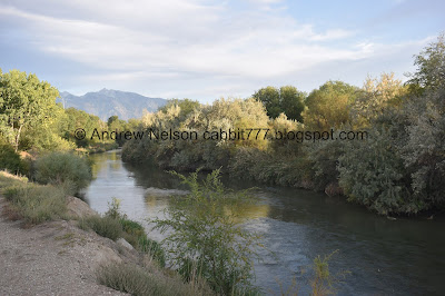
This is a nice section along the Parkway that features the river, the mountains, some wildlife, and even some wildflowers. This part of the trail stays far enough away from houses that it doesn’t feel super intrusive.
Length: 2.6 Miles out and back.
Official Trailhead: North: yes, south: no
Trail Type: Connecter, Out and Back, Balloon
Rating: 8 Squirrels
Cities: Murray
JRP Mile Markers 27.
Interesting Things: NA
Jordan River Parkway: Germania Park To Arrowhead Park AKA 5400 S. to 4700 South.
Update: Here is the full paved path between parks.

This section has been dedicated as a park and has a couple alternate routes. We mostly walked along the alternate routes today and enjoyed the river.
We finally did the full thing, but I still might re-tackle this one since we were mostly on alternate trails.
Length: 3 Miles out and back.
Official Trailhead: North: Yes, south: Yes
Trail Type: Connecter, Out and Back, Loop options.
Rating: 8 Squirrels
Cities: Murray
Mile Markers: 28, 29
Interesting Things: Little Cottonwood Confluence, Hunters Woods, restoration areas.
Alternate: Germania Park: Alternate Trails
Alternate: Little Confluence Park and Arrowhead Park
Alternate Loop: Hunters Woods Loop Arrowhead Park to Little Confluence Park to Germania Park and back. Hunters Woods Loop
Arrowhead Park to WW2 Memorial Park
This section of The Jordan River Parkway is quite lovely with quite a few neat things to see along the way. It connects to Arrowhead Park and several other fun trails.
Length: 1.2 Miles out and back.
Official Trailhead: North: Yes, south: Yes
Trail Type: Connecter, Out and Back
Rating: 8 Squirrels
Cities: Murray, Taylorsville
Mile Markers: none
Interesting Things: Low head dam, that they appear to be restoring, WW2 Memorial Park, Welsh Settlement marker.
WW2 Memorial Park to General Holm Park

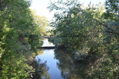
This section of The Jordan River Parkway was surprisingly wild for the most part which made for a lovely walk with great views of the mountains.
Length: 3.2 Miles out and back.
Official Trailhead: North: Yes, south: Yes
Trail Type: Connecter, Out and Back
Rating: 8 Squirrels
Cities: Murray, Taylorsville, South Salt Lake
Mile Markers: 30 and 31
Interesting Things: Big Cottonwood Confluence.
General Holm Park to James Madison Trailhead

This section of the Jordan River Parkway was surprisingly enjoyable. It it mostly wooded and far enough from houses. So it seems like a nice little forest in the middle of the city. Much of the trail is away from the river, but overall is is quite lovely.
Length: 2 Miles out and back, 2.3 miles balloon option.Official Trailhead: North: Yes, south: Yes
Trail Type: Connecter, Out and Back, balloon
Rating: 8 Squirrels
Cities: Murray, South Salt Lake
Mile Markers: 32
Interesting Things: Carlisle Family Historical Marker, The Tracy Aviary Jordan River Nature Center plus their native plant beds along the trail, Major General George P. Holm Memorial.
James Madison Trail head to Redwood Trailhead Park

Official Trailhead: North: Yes, south: Yes
Trail Type: Connecter, Out and Back, balloon
Rating: 8 Squirrels
Cities: South Salt Lake, West Valley
Mile Markers: 33, 34
Interesting Things: 1 of 2 suspension bridges in the valley. Oldest standing structure in West Valley (slight detour) Mill Creek Confluence, Beaver activity, Redwood Nature Area.
This, was not my favorite part of parkway. There were a couple neat things to see but the first half was an industrial area and the very noisy 201 freeway. The second half was basically a big homeless camp. The previous sections had some homeless camps, but they were generally away from the trail, these are right on the trail.
Official Trailhead: North: Yes, south: Yes
Trail Type: Connecter, Out and Back
Rating: 5 Squirrels
Cities: West Valley, Salt Lake City
Mile Markers: 35

Official Trailhead: North: Yes-ish, south: Yes
Trail Type: Connecter, Out and Back
Rating: 9 Squirrels
Cities: Salt Lake City
Mile Markers: 36, 37

Official Trailhead: North: Yes, south: Yes-ish
Trail Type: Connecter, Out and Back
Rating: 9 Squirrels
Cities: Salt Lake City
Mile Markers: 38, 39
North Temple to Riverside Park + Extra

This was an alright section along the trail. Like the previous sections there is a pretty good greenbelt around the river so it still felt pretty wild even in the heart of the city. But there wasn’t anything particularly fascinating, and there are a lot of homeless camps though here too. Technically I could have stopped at Riverside Park on 800 N, as that is where I left off coming from the other direction, but there was a detour last time, so I added 2 blocks to re-do that part.
Official Trailhead: North: Yes (if you stop at riverside park), south: Yes
Trail Type: Connecter, Out and Back, Partial loop options
Rating: 7 Squirrels
Cities: Salt Lake City
Mile Markers: 40, 41
Riverside Park to 1800 North. (reroute due to construction)

This section follows along a golf course as well, and is fairly pretty offering a lot of views of the river. However, it is starting to get into a little bit of a sketchy area, and I certainly did not like the reroute.
Length: 3.6 Miles out and back normally, 3.9 with detour.
Official Trailhead: North: Yes, south: Yes
Trail Type: Connecter, Out and Back
Rating: 4 Squirrels
Cities: Salt Lake
Mile Markers: 42
Interesting Things: Some interesting mementos from the 2002 Olympics. New constructed wetland wildlife park (what was being built during the re-route).

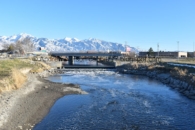
I revisited this north end of the trail in October of 2023. This is another nice section that passes by a golf course, and a OHV park, so it feels mostly wild and is quite enjoyable. At least until you hit the freeways.
Length: About 4 miles out and back, but with some extra exploring I did over 5.
Official Trailhead: North: No, south: Yes
Trail Type: Connecter, Out and Back
Rating: 7 Squirrels
Cities: Salt Lake City, Unincorporated, and North Salt Lake. Counties: Salt Lake and Davis
Mile Markers: 43 and 44
Interesting Things: Signs of beaver activity, art from the 2002 Winter Olympics, Views of Downtown. Connection to Legacy Parkway, County Crossing.
Alternates: 1800 North To Pony Express RV Resort TH and Pony River Express RV Resort to Center Street (north end of the Jordan River Parkway, South end of Legacy Parkway)


No comments:
Post a Comment