.jpg)
Alien Tower is a small sub peak with a strange old tower located in the Draper foothills. The trail features wildflowers, a sub peak, and incredible views of both the Salt Lake and Utah Valleys. Alien Tower is actually a spur off of the main Deer Ridge Loop AKA: West Bluff Off Leash Test Trail. This is a great hike that we tend to do pretty often.
Quick Details:
Length: 2.7 mile lollypop with spur.
Trail Type: Lollypop with spur, out and back options.
Difficulty: There is a bit of a climb, but its not too bad. DR3.
Elevation Gain: 550 ft.
Restroom: Yes. There are fantastic new flush toilets.
Dogs? Yes. They can be off-leash on the main loop, but need to be leashed on the spur.
Other Info:
To Get Here:
Take exit 288 for 14600 So. Keep left at the fork. Turn right on Traverse Ridge Rd, turn right on Deer Ridge Dr . Take that to the end.

Heading up Traverse Ridge Road we pass by Potato Hill on the left (Passenger Seat Photography (PSP)).

Little Valley on the right (PSP).

Neat old water tower (PSP).

Oh, there is a new sign, yay (PSP). Yes this is the right trail. Alien Tower is a spur off if the Deer Ridge Loop.

The FANTASTIC new trailhead! This popped up last summer. Flush toilets, sinks, drinking fountains, and 2 covered picnic areas. Plus a lot more parking!
The Trail:

You want to follow the wide dirt road to the right of the restrooms. No more chain to have to step over, now there is a gap on the left side of the first gate.

Mount Timpanogos.

There is no “Poop Fairy” Please clean up after your dog.

Trail rules.

The 2nd gate.

Then pretty green hills! I love the foothills this time of year.

Looking back towards Mount Jordan.

There is our destination. You can just barely make out the tower.

The Salt Lake Valley below. Oof, it is a bit hazy today. I thought it was lake dust at first, but apparently Idaho, California, Oregon, and Washington all have a bunch of fires right now and we are getting some of the smoke.

Just a little further and you can see Utah Valley.

Salt Lake Valley again. You can see The Claw from up here! I know I point it out every single time, but it is neat to have such a big recognizable thing from this far away.

More green hills.

Here is where the loop splits off from the main trail. You can go up that way, it is a little shorter, but it is a little tougher. So we prefer to stay to the right.

I wonder what this white stuff is?
Also, this area was starting to be developed, so you will see manholes, fire hydrants, and power boxes along the way. It is a long saga, but the short version is: Draper wanted to preserve more open space, and the greedy developers didn't want to accommodate that. Consider how much Draper had to have spent to improve the trailhead here, I would imagine they are not going to budge. That does not mean this area will never be developed though. It is nice to see at least one city care about our open spaces.

More weird white stuff.

Random rock heart.

The Salt Lake Valley again.
.jpg)
Panoramic.

Now we just have to climb this.

The SL Valley again. With Antelope Island, and The Claw.
.jpg)
Another panoramic.

The climb.
.jpg)
Another panoramic.

The valley again. We are aligned with some of the streets below.
.jpg)
Panoramic with Mount Jordan.

Then we hit the rocks section. I don’t know why they added the rocks, but they suck to walk on.

Apparently we are not the only people who think that, as a thin desire path has been worked in to the right.

At the top we get a short break from the climb for a minute. Phew!


The rusted remains of what I think was an old car.

Nice and smooth for a little bit.

Our destination again.

Here is where the Alien Tower spur splits off to the right.

Back to the climb. Oi.

The tower again.

Mount Timpanogos again.

Random little pond.

We just need to make it up to, then across that ridge. Easy peasey!

Dry Creek Canyon, Box Elder Peak, and Mount Timpanogos.

This is the worst of the climb, and it’s not even that bad, plus it is short.

Some larkspur, some bailhead waterleaf, and a lizard I totally did not notice when I took this picture.

Quick little crop into the lizard. He’s cute.

Lizard and larkspur.

Phlox.

We made it to the top! Phew! Well, not quite the top, but the top of the steeper part.

Just a little ways to go.

Utah Lake.

Into the scrub oak.

Another short steep part.

Mount Jordan again.

Some paintbrush.

Milkvetch.

Larkspur.

Scrub oak.

Back side of some signs. We’ll see them on the way down, but they are just the rules for entering the Deer Ridge area. I also suspect this might be the border of Draper.

A hawk hovering up above. I suspect a kestrel.

Almost up on the ridge.

The Jordan Narrows to the west.


More paintbrush.

Up on the ridge! Where we get a break from the climb for a little bit. The ridge is nice and wide, so even with the strong wind we are dealing with today I did just fine and didn’t struggle with my fear of heights. We did however decide that we should put our hats in the bag so we didn’t lose them.

Milkvetch and paintbrush.


Closer.

A better view of the Utah Valley and Utah Lake.

Mount Jordan again.

The Salt Lake Valley.

Utah Valley.

Almost there!

The tower.

Paintbrush and milkvetch.


Lots of milkvetch lining the trail.

Getting closer.

More milkvetch.

The SL Valley.

Another short steep part.

The final push.

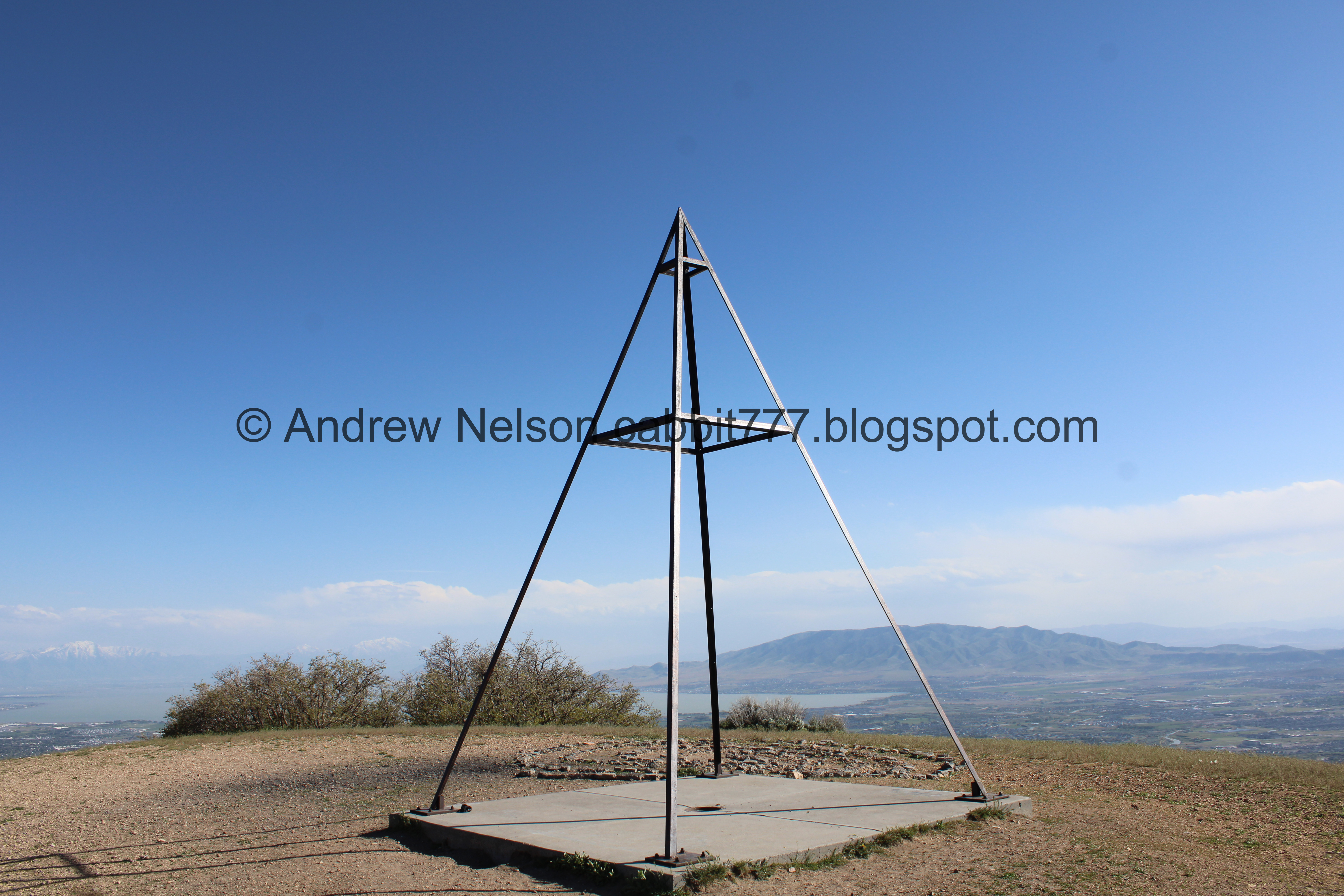
We made it! Phew!

The old tower. I don’t know for sure, but I suspect it was a telegraph tower. I decided that based on a nearby trail called Telegraph Hill. Still need to check that out some time.

A big rock spiral. Is this a thing now? Because this is not the first one I have seen. I saw another one on Ladyfinger Point, and one in Big Cottonwood Regional Park. However none of them compare to the original, The Spiral Jetty.

Under the tower.

The SL Valley.
.jpg)
Panoramic.

Utah Valley.
.jpg)
Panoramic.

The spiral and the tower.

The spiral.

The west side of Utah Valley.

Spiral and tower again.

Mount Timpanogos and American Fork Canyon.
There is an old Native American legend about the maiden on Timpanogos and you can kind of see it here, with the hair flowing out to the left.
.jpg)
Panoramic of the mountains.

Mount Jordan again.

The SL Valley.

Utah Valley.

It has been a minute since we had the peak to ourselves, but the wind was something else today! So, we decided we had enough of it and decided to head back down.

More paintbrush.

Heading down the wide ridge.

Milkvetch.

The SL Valley again.
I am pretty sure that is the Burnham Gorge below.

The SL Valley again.
.jpg)
Panoramic.

Milkvetch lined trail.

Milkvetch.

Paintbrush.


More milkvetch.

Paintbrush.

Utah Lake.

Looking back at the milkvetch lining the trail.

Continuing along the ridge.

The SL Valley.

Utah Valley and Utah Lake.

Heading back down.

Another smaller, unnamed peak. It is a super short add-on if you want.

The other side of the signs, and what I suspect is entering back into Draper.

Larkspur.

Lots of them.

Closer.

Steep part.

Bottom of the ridge.

Another steep part.

Waterleaf.

Peaks to the east.

The weird little pond again.

Back down to the Deer Ridge Loop. We decided to go down the other side, to the right.

The SL Valley.

Mount Jordan again.

Sage brush.

Scrub oak.

Looking back at the tower.

The turn off to stay on the loop is kind of subtle. But, if you miss it the trail doesn’t go for much longer. So it is a quick turn around and try again.

Pretty purple larkspur.

There are 2 trails right next to each other that join together below. Both trails are steep and rocky but the west one is slightly less so.

Super rocky.

Phlox.

More rocky trail.

More larkspur.

Scrub oak.

Big patch of waterleaf.

Crumbling hillside.

Utah Valley.

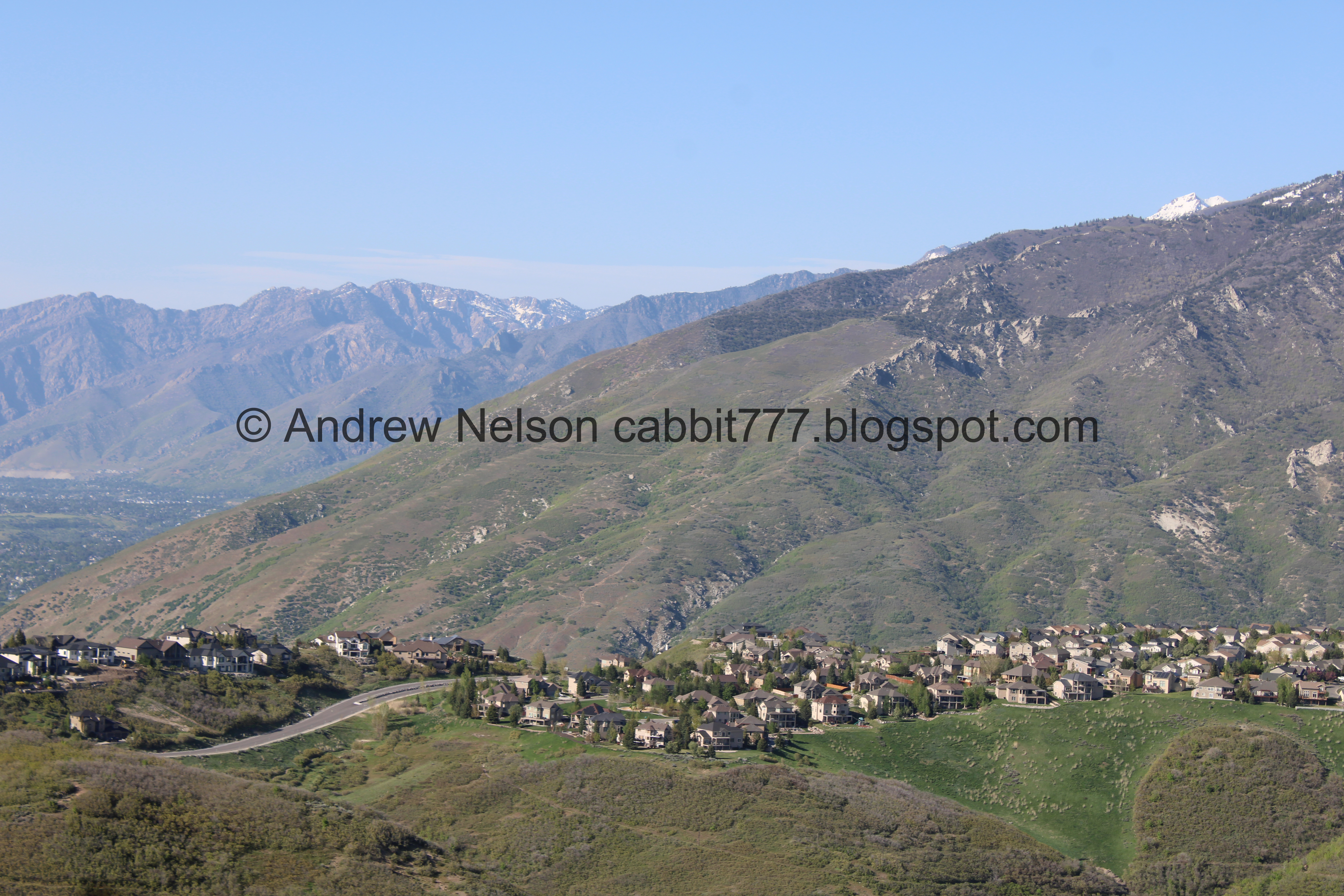
Mount Jordan, Dry Creek Canyon, and Box Elder Peak.
.jpg)
Panoramic.

American Fork Canyon and Mount Timpanogos.

More phlox.

Getting a little less rocky.

The SL Valley again.

Almost down to where the loop connects again.

Along the main trail.

Looking back at the green hills.

SL Valley again.

Manhole and storm drain.

Utah Valley again.

More green hills.

Trail counter. They use these to see how popular trails are so they can justify making improvements, like the new trailhead we have here now with a fancy restroom and better parking.

Back down to the trailhead.

Remember to leash your pups back up. Following all of the rules will ensure we get to keep this special off leash area.

The moon over Mount Timpanogos.

The new trailhead area again. I really love the improvements they have made.

Nearby Telegraph Trail. I still might need to check that one out.

Well, I thought that was a water tower, but now I don’t know what it is (PSP).

Passing by Potato Hill again (PSP).

Well, it looks like they did finally remove Rockwell (PSP).
Well, that was a fun day! I really could have done without the wind though. Otherwise it was a great hike with amazing views. It wasn’t very busy, and we even got the peak to ourselves for a while! There were also some lovely wildflowers along the way. 9 out of 10 squirrels.
As for difficulty, there are a couple short steeper parts, but otherwise it isn’t too bad. DR3.
Dogs are allowed, and can be off leash on the Deer Ridge Loop. Please clean up after your furry friends.

No comments:
Post a Comment