.jpg)
The Crosstown Trail is a paved inner city trail that as I understand it, goes from the Jordan River in West Valley all the way out to Magna! Although, I lost the separated trail at Parkway Park at about 3300 West, and it looks like it is sidewalks from there. This trail is part of an ongoing effort by the cities and county to make safe alternate commuter routes like the Jordan River Parkway and I suspect it is still a work in progress. Between this trail, the JRP, and Parleys Trail someone living in Magna could safely travel all the way to the east side of the valley. We decided after exploring Redwood Nature Park we still had some energy so we took this trail out to Decker Lake.
I was initially going to merge this post with Redwood Nature Park but decided it deserved it own post.

Quick Details:
Length: Looks like currently about 2.5 miles one way of mostly separated trailway and a little over 7 miles total one way. We did about 2.2 miles out and back.
Trail Type: Connector, out and back. Balloon option, bowtie option.
Difficulty: DR2. It’s paved and fairly flat.
Elevation Gain: Not sure about the whole thing, but we did about 17 feet today.
Restroom: Supposedly there is one at Decker Lake.
Dogs? Yes, leashed. Please clean up after your furry friends.
Other Info: One of few trails that is accessible via Trax. You can use the River Trail Station or the Redwood Junction Station.
To Get Here:
Take the 201 to the Redwood Rd exit in west valley. Head south for about a half a mile and turn left on (if you can get over fast enough) on Parkway BLVD. Take that east to Chartham St. turn right and take that to Crystal Ave and turn left. Go to the end of Crystal Ave, turn right on Chesterfield St. Find street parking and head south.
You cannot turn left on Crystal Ave from Redwood heading south. So if you were unable to get over fast enough, you will need to go further south and flip around. There is another light on 3100 S. to turn around and head back north, then turn right on Crystal Ave. go to the end of Crystal Ave, turn right on Chesterfield St. Find street parking and head south.
FYI: Google will recommend you park at the American Preparatory Academy, but there is no crossing there so don’t do that.
If you’d prefer not to park on the street there is a parking lot at the nearby Redwood Trailhead Park (this will add about 6/10th of a mile each way along the Jordan River Parkway. Or, you can just park at Decker Lake.
The Trail:
As I said, I added this on to Redwood Nature Park so today we will be starting from the northwest corner, about 3/10ths of a mile in.

Nice little forested section that follows the Surplus Canal to the right.
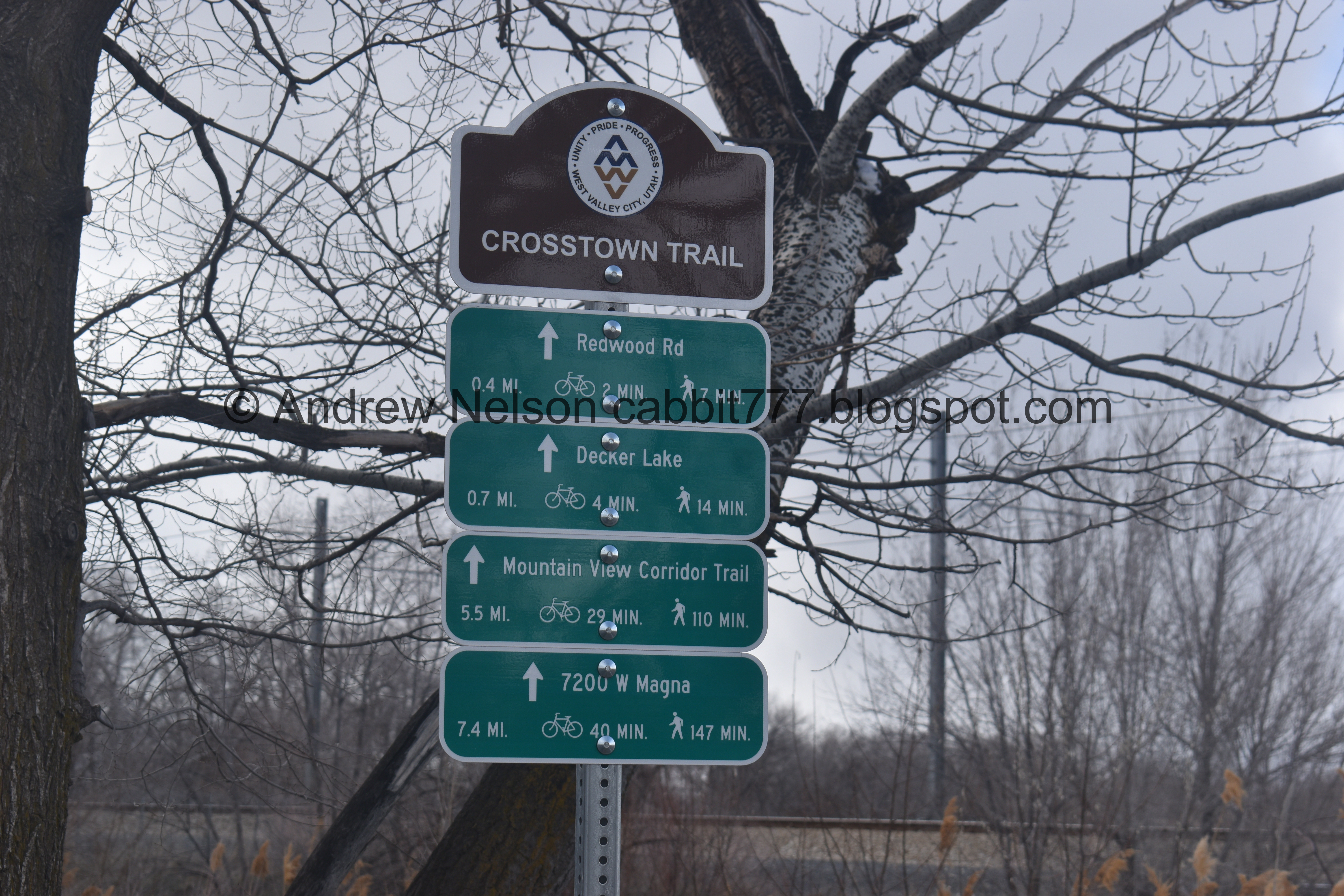
Mileage sign. See it goes all the way to Magna, and connects to the Mountain View Corridor Trail.

More lovely forest.

We passed by a farm that had some goats and sheep. Look at those totally adorable baby goats!!!


Ahhh! So cute!

They also have some horses and chickens.

The Surplus Canal.

Bridge over the Brighton North-point Canal.

You are also following the Trax Greenline for a bit.

First street crossing at the very not busy Lester Ave.

The Trax lines get a little closer through here.

Redwood Rd is a lot busier, luckily there is a lighted crosswalk. It is a bit of a wait though.

Then there is a section that is just standard sidewalk next to the Redwood Junction Station.

Eventually I noticed all the signs for the Crosstown Trail were on the other (north) side of the road! So I used the next crosswalk to cross over there. Pro tip, there is no need to do so. I have absolutely NO idea why they decided the north side should be the “official” trail as you end up crossing to the south side eventually anyway.

The view is not any different.

This is in one of the main flight paths for the airport so you can see planes here.

Crossing Decker Lake Dr. It wasn’t too busy, and is lighted as well.

Then Decker Lake BLVD. Again, not terribly busy. Don't worry, there are little signs tell you where to turn. Well, everywhere except the Redwood Crossing.

Final crossing at the even less busy Decker Ln.

First view of Decker Lake. You can go around either side, the the Crosstown Trail is to the right. It is about 1.3 miles around Decker Lake. We decided we would stay on the Crosstown Trail and decide if we wanted to do the full loop or not.

Where the Surplus Canal leaves the lake.

The lake again. I am fairly sure this is man-made, or at least man-enhanced.

Storms out west.

American coots swimming away.
.jpg)
Panoramic.

One of the few, what I suspect are, storm water drainage inlets.

Pelican coming in for a landing.
.jpg)
Another panoramic.

A bunch of Canada geese.

Some American avocets.

Another pelican.

Eventually I decided to pull out the telephoto lens. We don’t see American avocets very often. so it was worth the effort.

LOL nice landing.

They are neat birds.

Sweeping for food.

I love their little upturned beaks.

With his beak open.

A huge flock of seagulls.

Another group of avocets, a seagull, and some trash.

The first group again.

American coot.

Back to the avocets.


Synchronized dipping.

American pelican.

There’s a pair of them.

A bunch of American coots.

The pelicans again. Only the one on the right has the breeding knob.
With the mountains.

Mountains over the lake.

Storm clouds out west.

Canada geese.

This pair were yelling at us.

Whoa! Look at them all!

A nice little bridge. Just ahead you can see a trail split. Left will continue around Decker Lake, and right will continue down the Crosstown Trail. We decided this was a good spot to go ahead and turn back. We probably could have continued around the lake, but we’ve done it before so, meh.

Again, I am not 100% sure, but this appears to be a storm water outflow.

Seagulls taking off.

The Canada geese again.

Clouds obscuring Mount Olympus.


Now the geese are taking off.


The whole flock is taking off!

Mountains and clouds.
.jpg)
Another panoramic.

Back to the avocets.

Mount Olympus above the lake.
.jpg)
Another panoramic.

More mountains.
.jpg)
Another panoramic.

Mileage sign.

Storms over the lake.

Where the water leaves the lake via the surplus canal.

One last view of the lake.

Then we go back to the city section.

Like I mentioned for some weird reason, the official trail wants you to cross to the north side here, but I honestly don’t see a need to do so. So, save yourself an extra crossing and stay on the south side.

Walking past the Redwood Junction Station.
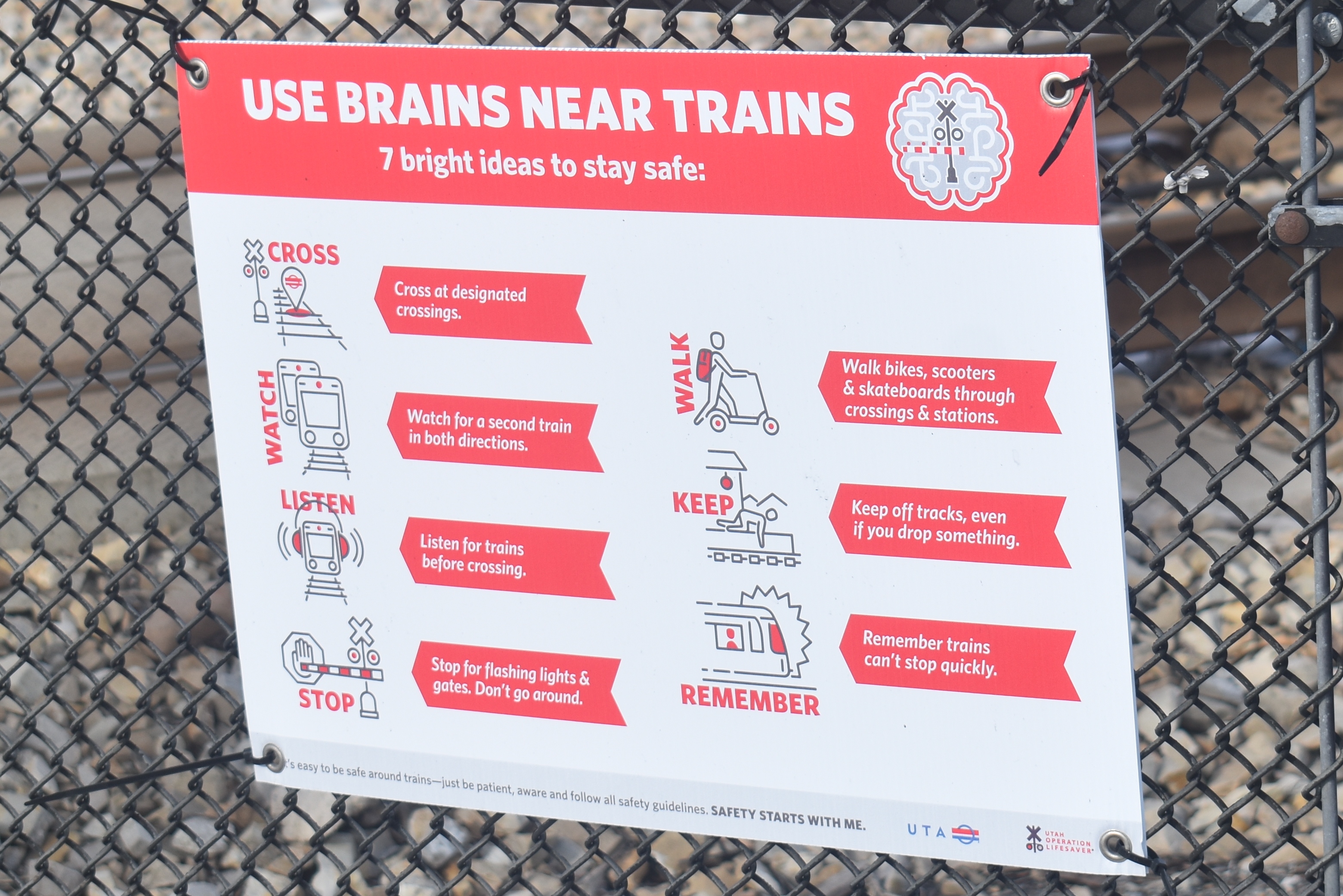
After crossing Redwood Road we found a train safety, with a bit of humor.

Back to the separated trail, along the Trax line.

Final crossing.

Pidgeon's.


Back to the farm with the goats and sheep. Silly goat has climbed up onto the feeder.

Passing Trax train.

More forest.

Back to the Redwood Nature Park. So, I am going to put the last 3/10th of a mile on that post, even though it technically fits into both.
I enjoyed the Decker Lake section, and the part east of Redwood Road, particularly near the Redwood Nature Park. I did not enjoy the city section very much, however I appreciate the effort the city and county are putting in to make these connecting trails. Going with 7 out 10 squirrels today.
As for difficulty, it is completely paved. DR2.
Dogs are allowed but should remain leashed.
