.jpg)
Alien Tower is a great little trail located in Draper. The trail features some scrub oak forest, wildflowers, amazing views of Salt Lake and Utah Counties, and an alien looking tower at the top of a small subpeak. I believe it is actually an old telegraph tower. A good portion of the trail is also an off-leash dog park. There are a couple sections that are a bit of a climb, but it’s not too bad. This is also a great way to get to a peak if you are squeamish about heights like I am. We like this trail and do it fairly often.

Quick Details:
Length: About 2.7 miles out and back.
Trail Type: Loop with a spur, or out and back.
Difficulty: DR3. It’s a good climb, but not too terrible.
Elevation Gain: About 500 feet.
Restroom: Every time I have gone there has been a port-o-potty present, but that’s not guaranteed. If it isn’t there the closest one I am aware of is at the Potato Hill Trailhead.
Dogs? Yes, off-leash within the main loop, leash required for the spur, and the short part at the beginning. Please clean up after your furry friends.
To Get Here:
Take exit 288 for 14600 So. Head east. Turn right on Traverse Ridge Rd, turn right on Deer Ridge Dr . Take that to the end. You will hike the old dirt road over the chain.

We passed by Potato Hill on the way up (Passenger Seat Photography (PSP)).

Looks like they are finally re-paving Deer Ridge Dr. (PSP)
The Trail:

After parking you are going to hop over this chain and follow the old dirt road. Remember to keep you dog leashed until you pass the next gate, in about 250 feet.

Said dirt road.

Map that shows the off-leash test area. Here you can unleash your dog if you want to.

Area rules. Huh. I thought this was called Deer Ridge, but apparently it is west Bluff. My previous adventures show the same sign, but google maps shows Deer Ridge. Odd. I wonder if it changed at some point.

Heading up the road.
You will notice some signs of development along the way, including what appears to be a fully fleshed out sewer system, electrical boxes, and even a fire hydrant. The short version of this story is: the area was, and last I checked, still is up for development. However, Draper City has a certain amount of space they want to leave as open space. So far none of the greedy ass developers have accepted those terms. And whoever put all the work in so far, abandoned it.

That is the peak we are heading towards. If you zoom in you can see the tower. It always seems so much further away than it actually is.

The Salt Lake Valley.

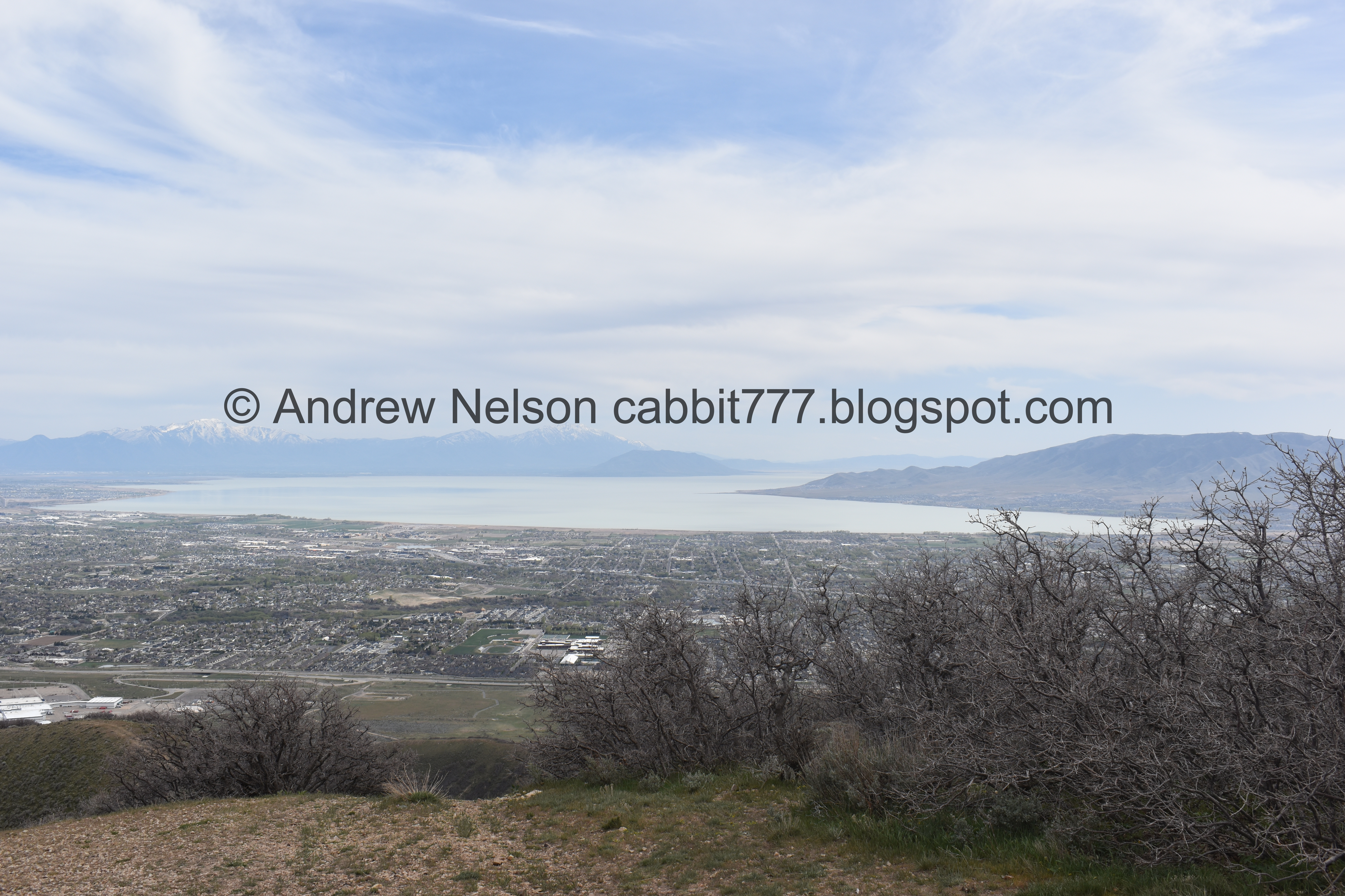
The Utah Valley.

Salt Lake again.

Well this is new, the Telegraph trails now connects up here.

The main loop again.

Where the main loop splits off. Both trails get you there, and I have thought over the years that the main loop to the right is the easier route, but I am looking at the elevation changes on my tracking app, and am starting to wonder if I might be mistaken.

A nice solar halo.

The Salt Lake Valley again.
.jpg)
Panoramic.

Antelope Island in the distance, and a little closer you can the Loveland Living Planet Aquarium’s Claw.

Now for the climb.

Salt Lake again.
.jpg)
Another panoramic.

The climb. It's a bit much, but not too bad.

The valley again.

Oof.

Looking back towards Mount Jordan.

More of the climb.

Where it flattens out for a bit.

You don’t want this first trail split, you want the next one.

2nd trail split. This is the one you want. The sign seems to have been removed, but it used to have the same signs all the other splits do, saying that dogs need to be leashed. It’s possible they changed the rules on this split, but I doubt it. Safest bet is to just leash them.

Mount Timpanogos.

The peak we are heading towards.

I think this short section is the steepest part.

As you reach the ridge you get a break from the climb for a minute.

Lone Peak, Dry Canyon (where you can hike to Horsetail Falls), and Box Elder Peak.

It is refreshing to see an ‘Entering private property’ sign vs. the usual ‘No trespassing, private property’. This is just an observation, don’t go that way. Not sure where it leads.

Entering the scrub oaks.

Mount Jordan again.

Okay, this really short spot is probably actually the steepest spot. But it’s short.

Ahh! Glacier lilies! Finally! I have been complaining that we have not seen any glacier lilies lately, as they, in my mind, are really the first sign of spring. So yay.

I seem to recall identifying these but cant recall it at the moment.

Some other little yellow wildflowers.

Another steeper part.

The butterflies were teasing me today and not sitting still enough for a good shot. But I am happy to see they are out and about.

Getting close.

Paintbrush.

Utah Lake.

Almost there.

Closer view.

Milk vetch.

Utah Lake again.

Continuing along the ridge.

Almost there.

The Salt Lake Valley again.

Milk vetch and paintbrush.

Closer to the milk vetch.

Paintbrush.
I am just so thrilled to start seeing the wildflowers again.

Almost there.
This is the worst of it, in terms of being up there. As you can see the ridge is nice and wide, and has a gentle slope. It doesn’t trigger my fear of heights at all.

Another butterfly that wouldn’t let me get closer.

Almost there.

We made it! I had to delete a few people out of this shot, busy up here today.

Mount Timpanogos and American Fork Canyon.

Mount Jordan, Dry Canyon, and Box Elder Peak.

Back to the tower.

Again.

With Antelope Island.

Utah County.
More of Utah Lake.
.jpg)
Panoramic.

The tower again.

Looking up.
.jpg)
360 degree pano.

Another butterfly.

Utah Lake.

Itty bitty little flower.
The tower and Mount Timpanogos.

With Mount Jordan.

The Salt Lake Valley.
We actually got it to ourselves for a hot minute.
.jpg)
Another 360 panoramic.

The Kennecott Copper Mine.

The tower again.

Another butterfly.

The tower on the peak.

Utah Lake again.

Looking up in the tower again.

Alright, another group arrived so we decided to head back down.

Another butterfly. They really were teasing me today.

Trails below.

Heading down the ridge.

I don’t know for sure, but this looks like it might be petrified wood.

Kennecott again.

More milk vetch.

More paintbrush.

The new trail below.

Mount Jordan again.

Salt Lake County.

Utah County.

Another sub-peak you can climb if you feel the desire. It is un-named and not a terrible climb. We did that last time. It will only add about a 10th of a mile.

Another butterfly.

Glacier lilies.

More, and a double bloom.

More scrub oak.

Back to the short steep spot.

We decided to go down the other side of the loop. You can unleash your dog again at this point, if you want.

Another view of the Salt Lake Valley.

Mount Jordan again.

Weird looking flower. I am not 100% sure, but I am leaning towards this being an immature reflexed rockcress.


Some kind of hawk. It wasn’t very close, and by the time I got to the telephoto lens it was gone, so I don’t know what kind. Leaning towards a red-tailed though.

Looking back at the peak.

Mount Jordan again.

Trail split to keep heading down. We have never missed it, but I don’t think it is the end of the world if you do. It doesn’t look like it keeps going for very long.

Well these are cute. I wonder what they might be.

Mount Timpanogos again.
I can’t remember the whole story at the moment, but apparently one of the local Native tribes had a story about an Native maiden laying at the top of Mount Timpanogos to die and you can still see her. I can see her pretty clearly today.

Heading down.

Lots of little doggo prints.

More scrub oak.

More flowers. I think this is something in the mint family.

Utah County again.

Little rockslide.

The little canyon leading to Utah County.

Salt Lake County.

Where the loop combines again.

Electrical box.

Salt Lake County again.

Utah County again.

Nearing the end. Remember to leash your dogs back up when you hit the fence.

Looks like they have added a tracking box. Nothing to worry about, it just tracks how many people pass by. They are just trying to collect data on how many people are using the area. We have seen these, more and more often, on various trails. Some like this with no info, and some with a sign telling you what it is.

More left over stuff from the previous development attempt.


Back at the trailhead we were treated to a kestrel hunting.

So pretty.


It is so neat to watch them hover. They can hold their place really well, even with the wind. I wish I had thought to take some video.

Whoa! It is freaking upside down and it’s head is still fixated to it’s target. I think this was mid dive.


This is such a fun experience.

They really are such pretty birds.


Little closer.

I love him.

Another dive.

Better shot of the beautiful colors.

Mount Timpanogos again.

Utah County again.


The kestrel is back!


Back to hovering.
Well, what a fantastic way to end a good hike! But I think it is time I pulled myself away from the kestrel and we start to head home.

Fun clouds.

Neat water tower (PSP).

Passing by Potato Hill again (PSP).
I am particularly fond of this hike. I just love the amazing views into Salt Lake and Utah Counties. I also like that is is a nice peak that my acrophobia can handle! It also was not terribly busy today, a little accumulation at the peak, but not to bad. All in all, 9 out of 10 squirrels today.
As for difficulty, this one is a bit of a climb, but not terrible. DR3.
Dogs are allowed, and can be off-leash for the majority of it. Just be sure to leash them back up at the spur, and the beginning.
