.jpg)
Waterfall Canyon is a beautiful canyon in Ogden that features, well, a waterfall. The waterfall is usually just a trickle, however in winter, that trickle fans out to an awe inspiring, epic 200+ foot high wall of ice. In wet years, the waterfall can be pretty impressive in spring too, though. Half of the trail is on an open slope without much shelter, and then the 2nd half climbs a pretty canyon. The trail is super, super icy and microspikes are a must.

Quick Details:
Length: About 2.8 miles out and back. We did 2.9 today so we must have wandered around at the top a bit more today.
Trail Type: Out and back.
Difficulty: Oh Boy DR4. It is a non stop climb, and a little tougher with the icy spots.
Elevation Gain: About 1500 ft.
Restroom: Yes. But I don’t know if it is open in winter.
Dogs? Yes, leashed.
Other Info: I definitely recommend microspikes in winter. Also, please note: this trail goes into private property that they still allow us to hike on. Help keep this trail open by respecting the land and by staying out of areas that are marked as off limits.
To Get Here:
Use the 29th street trailhead. Take i15 to 31th St exit in Ogden, head east. On Washington scooch north 3 blocks to 28th St. After the high school, which blocks 29th st on Harrison, use any street to go south 1 block to 29th street. Head east until you hit the mountain, turn right to the 29th St Trailhead. There is ample parking here.

The Kaysville Christmas Star (Passenger Seat Photography (PSP)). I have been wanting to get a picture of this for years now.
The Trail:

Malans Peak.

The trailhead kiosk.


Follow the signs for the Bonneville Shoreline Trail (BST). Basically, keep left until you start climbing.

Gibs Loop. We haven’t done that one yet, maybe some other time. Named for Gilbert “Gib” Wallace who spent a lot of time building a lot of the trails in the Ogden hillsides.

Kind of a gloomy day.

Icy patch. It was about here I decided that we should have our microspikes on. Super glad I did. This is nothing compared to higher up.

Before long you will hit the Bonneville Shoreline Trail (BST). This is looking north towards Ben Lomond, but we will be going south.

Some kind of hawk soaring above.

Not too far along the BST you will come to the property line of the TR Guest Ranch. This means you are entering private property that they have continued to let the public recreate on. Do your part to keep this open for us by staying on designated trails, out of areas marked private, and practice your standard leave no trace habits.

View across the valley again.

The BST is nice and wide.

Panoramic view of the valley below.

Looking back towards Ben Lomond.

First look at the old water towers.

Malans Peak.

Ben Lomond again.

The old water towers again.

Another panoramic.

Shortly after the old water towers, the BST swings into Waterfall canyon.
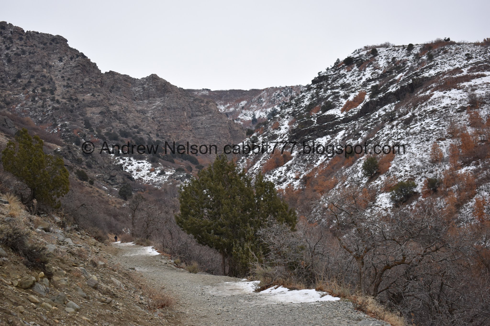
Looking up canyon.

This part is quite the climb!

I noticed this random layer of rocks that looks volcanic.

View down again.

Trail split. This is the Bonneville Shoreline Trail; Scenic Route. Which leads to the BST Christmas Tree (seasonal, obviously, and this is the longer route). I was a little surprised it didn’t have one of Ogden's amazing trail markers, and then I remembered we are on private property. So of course the city hasn’t erected a sign here. I have never been on this trail from this end, so I am not sure if there is a sign further along.

The first of 3 bridges. This is approximately halfway.

The creek. Hiding under the ice.

4 way trail split. Left is the way we want to go, continuing up Waterfall Canyon. Right will keep going along the BST. Forward leads to the private property on the TR Guest Ranch property. Note the chain closing it off. Again, head left. Also the nice wide trail gets a little thinner after here.

Starting to get really icy. I am glad we had our microspikes.

Old wooden pipe.

I’m pretty sure this crack is new, but it shows that it is wooden.

Where it connects to the diverter.

The 2nd bridge. After here the trail really starts to climb!

Hey we can see the creek through here.

Small cliffs with some vandalism that has been covered up.

View up canyon. We just have to make it to those cliffs.


Steep, rocky, icy climb. Oh boy. There is no way we would have made it without the microspikes.

View of the creek below.

View down canyon.

Little bit of a tight squeeze through the narrowest part of the canyon, but it’s not so bad.

View down through the narrow section.

The rest of the trail stays pretty close to the creek. You also get a brief break from the relentless climb though here.

Dead, but still clinging on leaves. In two different shades even.

The creek.

I love all the different ice formations you can see in creeks in winter.

The trail next to the creek.
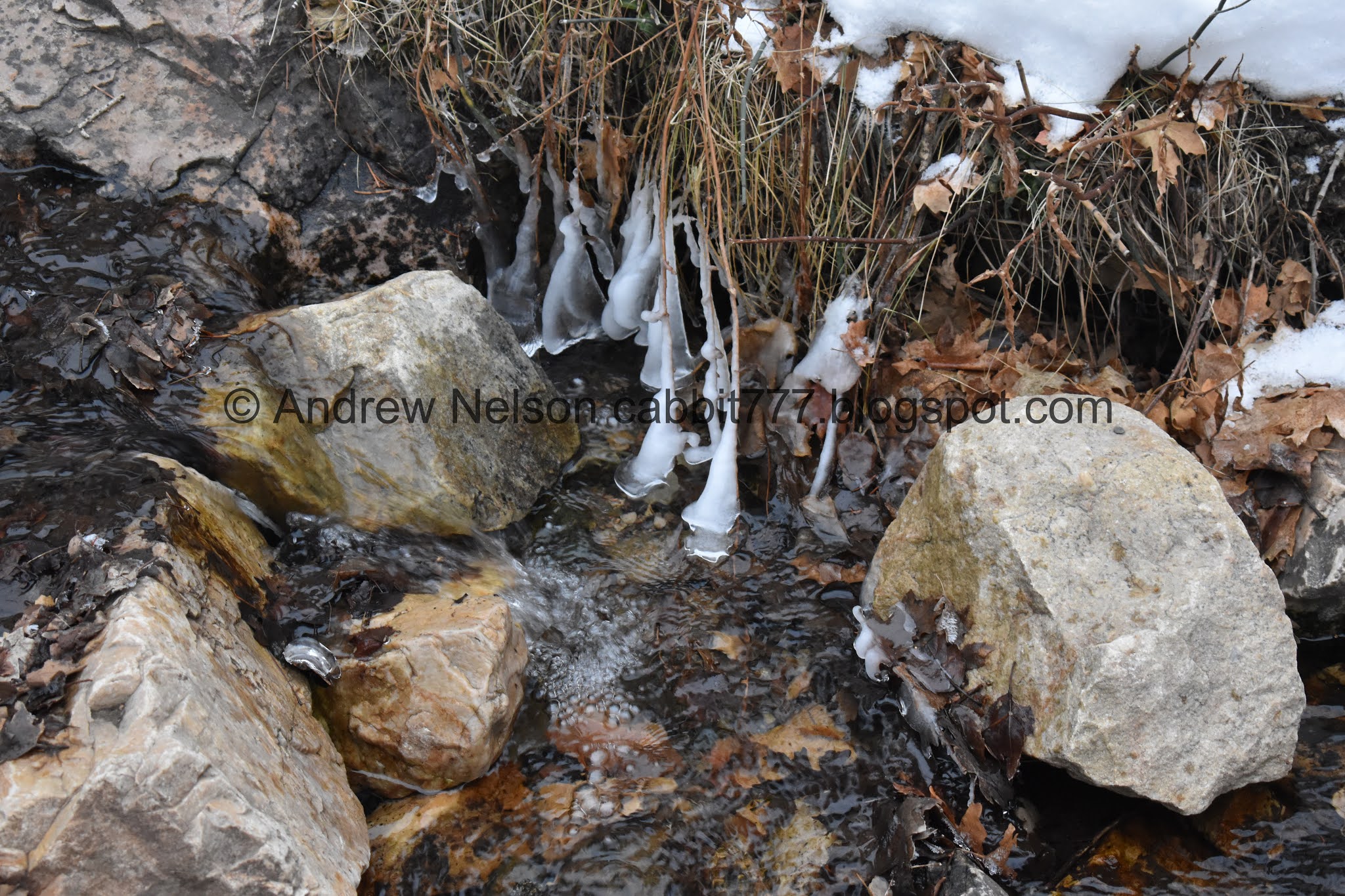
I don’t know if there is an official name for these formations but I call them ice skirts. Found on small plants hanging over a creek near a splashy section.

The creek again.

The waterfall is just on the other side of those cliffs.

Striped cliff.

The creek again.

Once we reached a certain point the creek was completely under ice. Not sure if it was elevation, or the cliffs sheltering it from the sun, probably both.

Iced around the trees.

More.

First glimpse of the waterfall.

It looks like there was a pretty significant rockslide here recently. It definitely occurred sometime between now and June of last year. That’s a little scary. I would not have wanted to be around when it happened.

Looking up.

Another peak-a-boo of the waterfall.

More debris.

Almost there.

The 3rd and final bridge is just a heavy duty plastic tube. Now for the final, scramble.

Another private area. Again, please respect their wishes and stay out.

We have been to the waterfall several times and it never fails to impress me.

I was so enamored with the amazing wall of ice that I didn’t bother getting any shots showing the final tough climb haha. But yeah, it is a bit of a scramble.

It is absolutely incredible!

With a human for scale.

Despite the weather forecast, it decided to snow on us from just before we reached the waterfall, to just a bit after leaving it. o.O
The whole thing again sans person.

Detail.

I love the alcove the waterfall is in.

Chunks of ice that have fallen off. Be careful exploring the base. Maybe observe from a distance first to ensure it is not breaking apart. Last time we came up in winter we got to witness that first hand.

Portrait panoramic.

Regular portrait.

The other side of the box canyon. A box canyon is a canyon that has one entrance with cliffs on either side, and not an easy way out from the other direction. I think this qualifies.

The impressive frozen falls again.

Another portrait panoramic.

View of the top.

Icicles behind icicles.

Detail.

Looking up.

One final shot.
We were a little worried this snow wasn’t going to let up so we wanted to get back.

Looking down canyon.

The frozen creek wrapped around trees.

Tree archway.

The creek through the snow.

View through the narrow section.

Fun rock formation.

Back down to the middle bridge.
Whew, that trail is awfully icy. Our microspikes don’t appear to handle downhill very well and we had a couple slips. Guess it is time to invest in better ones.

Back to the 4 way split. You want to head to the right. And the worst of the icy trail is over.

Back to the bottom and last bridge.

View out of the canyon into the valley below. At some point it stopped snowing and cleared up a bit. Phew! We were a little bit worried we’d be driving home in the snow.

The split for the BST; Scenic Route again. Keep left.

The valley below again.

Panoramic.

Back down to the old water tanks.

Another panoramic of the valley below.

Ben Lomond.
This trail is a relentless climb, but you are greatly rewarded for the effort. I think it is one of my favorite trails. At least in the winter, or a good run off year. On weekends the trail can be very crowded but on a random weekday it wasn’t too busy and we were comfortable with the small amount of people we passed today. 10 out of 10 squirrels. I almost took one away for the icy conditions, but decided that was more of an our equipment issue than a trail problem.

As for difficulty, like I said, this is a constant climb, and the last scramble at the end is rough. DR4.
Dogs are allowed, but must be leashed. Please clean up after your furry friends.
