.jpg)
Oak Hollow is a connector trail in Draper. It features some excellent views of the valley below as well as a nice scrub oak forest. There is not a lot of shade on this trail, so I wouldn't recommend it on a hot day.
The trail can be done as an out and back, or you can connect it to Spring Hollow and do a longer loop. If you use Highland Dr. at the bottom, then Traverse Ridge Rd. and E Mike Weir Dr. at the top it will be about 4.25 miles (this is an estimate measuring with google maps). But you could also use the BST to connect them at the top, which would be a little longer.
Quick Details:
Length: About 2.2 miles out and back.
Trail Type: Out and back, connector, loop options.
Difficulty: DR3. Its a pretty easy going climb.
Elevation Gain: About 350 feet.
Restroom: No, but there is one at nearby Potato Hill, or the Andy Ballard Arena restroom is open year round.
Dogs? Yes, on leash.
Other Info: 2 things: This trail starts at the top and and returns uphill. This can be a bit of a challenge if you are not used to going uphill. I couldn’t find anywhere to safely park near the lower TH.
Also, if you have a fear of heights, and struggle with higher up trails, this might not be for you. I made it though and I am really bad about that. The good news is, its at the beginning of the trail. So you don't invest a lot of time before encountering it.
To Get Here:
From I15 Take exit 288, or 14600 S in Draper. Go left. Go almost a mile and turn right on Traverse Ridge Dr. After about 8/10ths of a mile turn left into the signed parking lot.
The trailhead is on the east end.

Signed trailhead.
The Trail:

View from the trailhead. Oof. It is quite hazy today.

Trailhead kiosk.

I have never noticed this elevation sign before now. 5100 ft. Not super high.

The valley below again.

Into the scrub oak.


Fun tunnel that goes under Traverse Ridge Dr. This is actually not the way to go, but it was a super short detour (maybe 20 ft.) off the trail.

Valley views again. You can see the Loveland Living Planet Aquarium’s “claw" from here.

More scrub oak.

The hollow and the valley below.

Due to my fear of heights, I am not a fan of thin high up trails on steeper slopes. Honestly, this wasn’t too bad, but I kept psyching myself up for the unknown. There were 2 short spots that I didn’t like, but for the most part it was really not that bad.

Looking down into the hollow.

Crossing this old dirt road.

Looking back towards the hollow.

View of the valley again.

Mount Jordan.

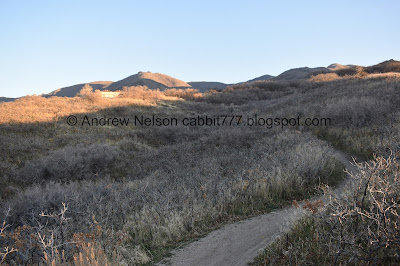
Once you cross over the ridge to the south the trail is on a much milder slope as you cross a couple smaller side hollows.

A nice jaunt through the sage and rabbitbrush.

The trail skirts around a golf course.
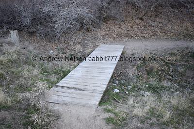
Bridge. This might have been a creek at some point but now I think it is just a run off channel.

Valley views again.

A wildflower still hanging on, although looking a little haggard.

Looking north towards downtown.

Southish. Draper and Riverton.
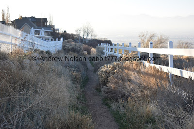
Short section that is squished between the golf course and housing. Nobody was out enjoying their yards today so it didn’t feel intrusive at all. Plus its lower down, and there is a lot of vegetation block most of the yards.

Into the final hollow.

Little side trail leads to a bench with a view, and the neighborhood above.

Through the scrub oak.

Another old creek bed and/or run off channel.

The hollow below.

Random chairs. Probably a local teen smoke spot.

Weird traffic circle with a pit in the center?

You want to go right. Left is another neighborhood access.

Fun tunnel.

Inside the traffic circle. This was a creative solution to needing a intersection in a narrow gully. Plus, draper sure loves traffic circles.

Smashing pumpkins. ... Why do I feel I need to clarify? I was referencing the band, with the already smashed pumpkins. We certainly did not haul pumpkins down to smash.

Another tunnel.

Inside.

Nearing the bottom of the gully.

Some water that seems to have been rerouted from somewhere. Possible one of the dry creek beds I crossed earlier.

This doesn’t seem to be enough covering for such a deep tube.

Then we hit Highland Drive. Like I said, you can take a right here go about 1.1 miles, and then head up Spring Hollow, or you can just turn around.

You can take this thin trail back, or the wider trail below. They both connect before the traffic circle.

The traffic circle.

First tunnel.

Inside the circle.

The other tunnel.

From above again.

Panoramic.

Neat little plant that is just starting to change color.

The random chairs again.

Heading up the first little hollow.

Through the scrub oak!

Mossy rock.

More forest.

Carpet of leaves.

Box Elder Peak above Potato Hill.

Back to the thin corridor between the golf course and houses.

Looks like some golfers might have take their cart around this corner too quickly.

Into the 2nd little hollow.

The valley below.

Panoramic.

Mount Jordan again.

Box Elder Peak above Potato Hill and Red Rock.
The 3rd little hollow. I guess all 5 of these hollows, 2 bigger ones on the outside, 3 smaller ones on the inside, all make up Oak Hollow.

The valley again. Again, you can see the Aquarium’s “claw”.
The 4th little hollow. This is the smallest of all of them.

The 5th, and biggest hollow.

Continuing up.

The Bonneville Shoreline Trail on the other side of the hollow. And I totally did not notice them when I took this picture, but there are a couple deer in my shot. My wildlife eyes are slipping!

Here is a cropped image.

So even though the trail is high up through this hollow, its mostly just fine.

Some ivy just starting to change color.

Hitting some more oaks.

Another run off channel.

One of the spots I didn’t like, but it was short.
Back up to the tunnel.

Trail signs.

In the tunnel again.

The valley again.

Final ascent.

The valley again.

Closer look allows you to see the claw.

The woodpeckers love this patch of dead trees.

The final jaunt to the trailhead.

Valley view from the trailhead. Boy is it hazy today.

Fading light on the peaks north.

Twin peaks.

Panoramic.

Driving by the Aquariums Claw (PSP).
That was an alright trail. Not too many people, excellent views. But it did trigger my fear of heights. I managed to power through to see it wasn’t as bad as my irrational lizard brain made it seem like, but yeah, its not fun. There isn’t really and end prize, but it does offer some great views. I would not recommend this trail on a hot summer day, but it is a good option for this time of year. 7 out of 10 squirrels.
As for difficulty, its a pretty mild climb, even if you start at the top and return up hill. DR3.
Dogs are allowed, but should remain leashed.
