.jpg)
The Jungle Trail in Corner Canyon is a fairly new trail that opened in 2019. It was specifically designed with kids in mind and has a bunch of fun obstacles for them to play on. The trail itself is only about 3 tenths of a mile (Update: they added a short cut that just shaved .15 miles off of it), but it takes about a half mile to reach it. For such a short jaunt it was a lot of fun and very pretty. I chose this trail today because Landis has an angry foot, so I didn’t want to do too long or too hard.
Quick Details:
Length: 1.3 miles out and back.
Trail Type: Balloon.
Difficulty: DR3 its pretty easy going but: you WILL have to duck under low hanging trees and other barriers.
Elevation Gain: About 150 feet.
Restroom: Not at this trailhead, but there is one at the nearby Andy Ballard Arena Trailhead.
Dogs? Yes, leashed. But, be aware you are skirting watershed. Be sure not to wander above the BST.
To Get Here:
Take i15 to the Bangerter Hwy exit and head east. Go about a half mile and turn left onto 13800 S. Take that 1.7 miles it will curve to the north. Turn right on 1300 E. Immediately turn left on Highland Dr. Turn right on Belchers Brook way, at the traffic circle, take the first exit onto Aintree Way. At the traffic circle, take the first exit onto Tuscalee Way. Slight left onto Carolina Hills Court, go to the end and park.
Or just use your GPS by typing in Carolina Hills Trailhead.
You could also park at the Andy Ballard Arena trailhead, this shouldn’t add too much extra distance.
The Trail:

Trailhead kiosk.

There are 3 trails here. You can either take the Lower Corner Canyon Rd. on the left, or this middle trail. The trail to the right goes elsewhere.

Rabbit brush.

Hitting some scrub oak.

Where the middle trail joins the Lower Corner Canyon Rd. Head right.
Also, new information to me on this sign. It says: “If you see a horse say hay! Horses need to hear a voice when approached.” I generally don’t approach horses, but this is good to know if I have to pass by one closely.

They seem really excited about the newish trail, lots of signs!

I say this every time. Of all of my adventuring this is the only place in Utah that I have ever seen poison ivy warnings. Of course that doesn’t mean its not elsewhere, maybe Draper is just extra cautious?

The creek below.

The Lower Corner Canyon Rd.


Right after the road crosses the creek you will come across the trailhead on the right.

Hah! I have never encountered such a sign before! But it is good the posted it. Kids wont have any issues, but some of us older folks might struggle a bit.

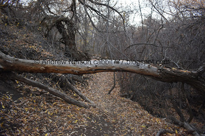
Fun bent tree.

Low branch to climb under.

Gnarly trees.
Another low tree to climb under.

Super gnarly tree.

The creek below.

I think I see why they call this the Jungle Trail.

Forest.

Fun little stump steps.

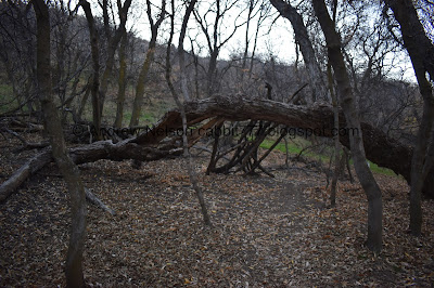
Neat little fort to explore.

Little reminder to stay on the trail.
Man the trees on this hillside are really bizarre.

More stump steps.

Another fun structure on another gnarly tree.

I wonder what might have happened that caused a lot of these trees to lay down against the upside of the hill.

Another gnarly tree.

Weird water diversion thingy.
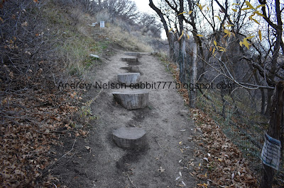
More fun stump steps.

More.

Then we reached the Creek View Trail (signifying the end of the short Jungle Trail). Which I have been meaning to check out but just haven’t yet. Anyway, right will take you down, then back up to the trailhead faster. Left appears to take you on a longer loop. Maybe next time. We went right.


Still a lovely hike in the woods.
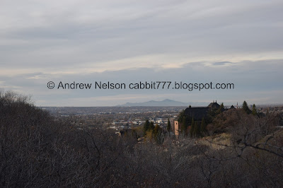
Valley view and you can see Antelope Island.

A little thin on a steeper slope, but my afraid of heights butt did okay through here.

Okay, some of it made me a little nervous haha. Can you see the game trail?

I can see where we parked from here.

It looks like they have built a newer shortcut here. Looks like it might shave 1 to maybe 2 tenths of a mile off. But I was still feeling adventurous. If I was a more consciences partner, I would have taken it though. Although, he did not object to taking the slightly longer route.
Update: We returned the following week and the shortcut is now complete and will shave off .15 of a mile.


More scrub oak.


Little patch of some colorful maple.

And something else.


More scrub oak.

Back down to the Lower Corner Canyon Road.

It is clearly signed as well, in case you come from the lower trailhead.
Now we just head back up the Lower Corner Canyon Road.

Just remember to keep to the right!

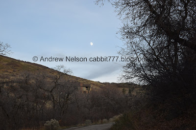
The moon over the trail.
Passing by the shortcut we saw earlier. Looks like they might still be working on it because the only sign is: Foot traffic only.
Update: We returned a week later and the short cut is now complete. It appears to shave about .15 of a mile off.

The creek bed, dry after being diverted. The bikes cruising down across this bridge made an awfully loud noise.

The other side.

Found another wildflower hanging on.

The moon again.

The Lower Corner Canyon rd.

Little bit of color by the road split. Hang a left here.

Closer.

Heading back towards the trailhead.

Fun clouds.

Back on the thinner trail.

Mouth of the canyon and the valley below.

The valley again.

Reservoir and the valley.

The Rush Trail was quite busy today. It’s a fast downhill bike trail.

We decided to stick around for the sunset.


Woo!


A couple Passenger Seat Photography (PSP) shots on the drive home.
Well, that was super short, but it was fun. It’s nice to have another enjoyable short hike to add to the list under my belt for those days I want to do one, but maybe don’t have a lot of time. The surrounding trails were pretty busy, but this one was not. Going with 9 out of 10 squirrels.
As for difficulty, it’s short and pretty easy going. DR3 with a warning that you will have to stoop under some low hanging branches.
Dogs are allowed, leashed. However, be aware you are skirting watershed. If you decide to explore some more, be sure to not to go above the Bonneville Shoreline Trail.

No comments:
Post a Comment