Barneys Creek Trail, not to be confused with the nearby Barneys Wash Trail, is a short, paved trail following the worlds most shallow gully, or I guess, a wash located in West Jordan. It features a dry wash, and passes by a couple of parks. I am going to be honest, I did not care much for this trail at all. The only real redeeming quality is that it offered some nice views of the mountains. Otherwise it just felt like a neighborhood walk. However, I just wanted to get the dogs some exercise and well, this meh trail was practically deserted so, mission accomplished? I don’t think I will come back though. The fact that the trail passes by a few parks might make it a good option for kids. Play in the park, walk for a bit, oh look, another park.
Quick Details:
Length: About 2.26 miles out and back.
Trail Type: Out and back. Looks like you can make an awkward balloon adding Clay Hollow Wash Trail. Doesn’t look like it would add too much.
Difficulty: It is paved, with a very mild climb. DR2.
Elevation Gain: About 100 feet.
Restroom: Not that I noticed.
Dogs? Yes, but must be leashed at all times.
To Get Here:
Take i215 to Redwood Rd. Head south to 7800 S and turn left. Go About 3 miles to 4800 W and turn left. Take the first right onto Amethyst Dr. And then the first right into the parking lot of Barneys Creek Park.
There is also a small parking strip on 4800 W That will connect to this trail. Just be sure to take the second, or furthest south path. The northern one leads to a neighborhood and I don't see it connecting to this trail.
The Trail:
Well, this might explain some of the confusion. I guess West Jordan considers this part of Barneys Wash, but Google maps considers it Barneys Creek. I don’t know what to think. o.O
Starting at Barneys Creek Park. Right leads to 4800 W. and it would be a similar distance. You want to hang a left here.
It starts out with a wide open field to your right. I imagine it will not be long before it is developed.
This is the shallowest gully ever! But I guess it is actually a wash. but, still just kind of bizarre. Also, I am curious why there were so many random Cement dams.
So shallow!
Inversion on the mountains.
The shallow wash again.
I imagine this is a flood control basin? But, unsure.
Looks like we are already building up some inversion after our last storm.
Are these fairy rings? Or something else? Super weird to see these rings of grass. If they are fairy rings, there is a fun, never expected to see for myself bucket list items.
Where Clay Hollow Wash joins Barneys Creek.
Don’t forget to look back and enjoy the mountains.
Crossing over Barneys Creek.
Trail split. You can make this a longer balloon by using the Clay Hollow Wash Trail to the right here.
You have to cross this small side street.
Now the creek bed will be to the left.
Looking back towards the mountains again.
The shallow wash again.
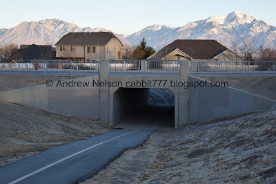
This road crossing has a tunnel. Probably because it is so close to a middle school.
In the tunnel.
The last leg is next to a middle school. It looks like the creek was re-routed to be on the back property of the school.
End of the line at 5600 W.
Afterwards I learned that if you go right down 5600 W., you can connect to the Clay Hollow Trail to make this a balloon. Or… you can go left for a bit and connect to the Barneys Wash Trail. I am not sure how much more either will add, but the Clay Hollow Trail is definitely shorter. We just turned around here.
On the way back we can enjoy the views of the mountains.
Another pile of tumbleweeds. I guess winter is when they start to blow around?
Whoa! You can see Mount Timpanogos from here!
Trail rules.
Little Cottonwood Canyon.
Heading back through the tunnel.
Ah. Middle school level graffiti.
Birds in a bush.
The shallow wash and the mountains above.
Panoramic. lets see if I get this right. Grandeur Peak, Mount Olympus, Twin Peaks, Lone Peak, Mount Timpanogos.
Wider panoramic.
Where Barneys Creek and Clay Hollow Wash join.
Another panoramic.
Back to the section that had possible fairy rings. So weird.
The wash again.
Looking back west to a little bit of sunset.
I did notice evidence of gophers so I wonder if maybe that might be what’s happening here? Honestly I have no clue.
Terrible shot of an American kestrel. I honestly thought it was a common robin at first, until I noticed the distinctive tail shape. wish I had noticed it sooner and had pulled out the telephoto lens.
Open field. Like I said, I can’t imagine it will be too long before it is developed.
Mountains again.
Another panoramic.
The shallow wash again.
There were random dams all along the way.
The final trail slit. Right to the park we parked in. Forward will take you to 4800 W.
Meh. I didn’t particularly like this trail. I mean, its better than some of those trails that feel like you are intruding into people yards, but still just an overall meh. I did enjoy the views of the mountains though, I also appreciated that we only passed one other couple along the way. 4 out of 10 squirrels.
As for difficulty, it is completely paved and pretty gentle incline. DR2.
Dogs are allowed, but must be leashed at all times.
.jpg)


No comments:
Post a Comment