.jpg)
The Big Cottonwood Canyon Trail, AKA, The Cottonwood Heights Historic Walk is a paved city trail in a gully below Big Cottonwood Canyon. Much of this trail feels no different than walking through a neighborhood, because well, that’s what you are doing haha. However there are several historical markers along to way to help learn about the history of the area. My original idea for the day was a little too crowded, so this was our plan B.

Quick Details:
Length: The entire trail is about 3.6 miles out and back. We did about 3 miles today.
Trail Type: Out and Back
Difficulty: DR2. It is completely paved, and mostly a mild climb, but there is a steady climb near the end though.
Elevation Gain: About 350 Ft.
Restroom: Yes, on the east end. It’s even heated.
Dogs? Yes, leashed.
Other Info: If you start at the east end you will go down, and return uphill.
To Get Here:
There are 3 trailheads. One is at the south end of the Park and Ride lot at the mouth of Big Cottonwood Canyon (this is what we used today).
The middle trailhead is located at 6708 S. Big Cottonwood Canyon Road.
The lower one is under i215, and requires going through business parking lots. I am not sure if there is any official parking. But the far west section is, through a bunch of businesses, so its not too exciting.
The Trail:

Oh boy the inversion is bad today (Passenger Seat Photography (PSP)).

Looking up Big Cottonwood Canyon.

A frozen Big Cottonwood Creek.

Heading under Wasatch Blvd.

More frozen creek.

The introductory sign to the Historic Walk. Cottonwood Heights is comprised of several smaller towns. Cottonwood, Big Cottonwood, Butler, Union, Granite, Poverty Flats, Danish Town, Emmaville and Gold City. I find some of these old town names interesting, considering Cottonwood Heights is one of the more affluent parts of the valley.
This sign also mentions that out of all of the historical things you will learn about on this trail, only 3 of them are still standing. And the only one you will see on this trail is The Old Mill.

Early settlers decided the flat area between the Cottonwood Canyons was the best place to set up camp. It also talks of the lumber industry in the canyons. There were several lumber mills up Big Cottonwood. Which explains why all the side creeks are named Mill (letter).

Slave owners sent their slaves ahead of them to build cabins. Shortly after emigrating many of them were granted emancipation. I will give you 3 guesses as to which town they ended up in. However, way back then, a thriving black community was very scarce. And they had key roles in what happened in the Union area.

The frozen creek again.

A single tree became a double tree. I wonder if something similar to bent trees caused this. With the bent trees, as I learned on the Limber Pine trail, the leader branch snapped off due to heavy snow, and a new leader branch took over. I am totally speculating here, but I wonder if the leader branch snapped, and 2 branches took on the leader branch duties?

The creek again.

McGhie Springs were originally on the McGhie property. Murray City made payments to purchase the land, and access to them and have the water redirected to Murray. They are still part of Murray Cities water supply.

The creek again.

The trail.

Little frozen cascade.

In 1867 William McGhie Jr and family settled in the mouth of Big Cottonwood Canyon. He offered rental services for all of the trades coming out of Big Cottonwood Canyon. In 1892 he was designated the first postmaster for Butlerville which was run out of his home. It was closed in 1902.

In 1869 Philander Butler settled and built a hotel above the location of the Old Mill. It became a resting place for those working in Big Cottonwood Canyon. He diverted water from Big Cottonwood Creek make a brewery.

In 1894 the community used the old pond from the Butler Brewery to store ice for the summer months in an ice house that was built into the hill side. They continued to harvest ice blocks until refrigeration became available.

There was a Civilians Conservation Camp near here. They built the Brighton Loop road, and many trails, water resources, and ski amenities in Big Cottonwood Canyon.

Oh hooray! Sometime between the last time we did this trail, in 2016, and now, they managed to pave this section. It used to be a very narrow dirt shoulder for about 1000 yards. Looks like some trees had to be sacrificed for it, which is a shame, but it does seem quite a bit safer now.

Looking back towards Big Cottonwood Canyon.

And Neffs Canyon.

I think this is the last of the newly paved segment.

I think it is terrible enough that people build random cairns on normal trails (seriously, cairns are meant to be way markers, not decorations) but to do so on someone’s private curb strip. is just disrespectful.

Pretty much just like walking down any random neighborhood street.

Crossing the now dry Big Cottonwood Creek.


The Old Mill.

Sans people.

The back.

The cedar tree, one of the earliest trees planted in the area, was planted in 1894. I am not 100% sure, but I think it is the one next to the old mill, which is east of here.

Or maybe it is one of those 2 trees to the right here. I don’t know.

A big 2 story cabin built by prominent members of Butlerville.

In 1910 a silica mine was opened above here, they built a lot of infrastructure to transport the silica, until it was discovered it was inferior quality and was eventually abandoned. Interesting. You can see remnants of another silica pit in Corner Canyon.

One of the whimsical things that happens on trails around the Wasatch Front in December is random trailside Christmas Trees. I don’t mind them, so long as whoever does it returns in early January to clean it up. After that I consider it littering. This is the first one I can think of that is not on a conifer tree.

You can’t do any historical stuff in Utah without running into something about the Mormons. This is one of the still standing structures, though it has been moved twice.

Looking back at the mountains. I believe that is Twin Peaks up there.


Okay seriously, this rock painting trend needs to stop. There is so much of it through here. It’s super tacky. However, I guess I prefer it stays on these more urban trails, than in the woods. But seriously, this is too much.

In the 1860’s mining took off. Emmaville, had a couple of setbacks and moved several times due to varying success of mines. Gold City popped up with a successful mine, but only lasted a few months.


One of a few covered pedestrian bridges I am aware of. I have yet to locate a covered bridge in Utah that was meant for vehicles. I am not sure if the trend never made it here, or if none of them survived.

A reservoir. We’ve only done this trail in winter so I have never seen it full, not sure if it is even used anymore.

More Mormon history. They built a chapel between the 2 canyons out of the granite from the canyons. It didn’t work out, and nothing of it remains.

Looking back at the covered bridge.
My original goal was to make it to the covered bridge, but we decided to go a little further, until hit 3000 east. We changed our minds again just a little further down.


This marker actually goes with something still standing.


Walking along the reservoir.

The South Butler School was built in 1892. In 1919 or 1920 the school was torn down and the brick was used to build the Burgon Market.

The reservoir spillway.
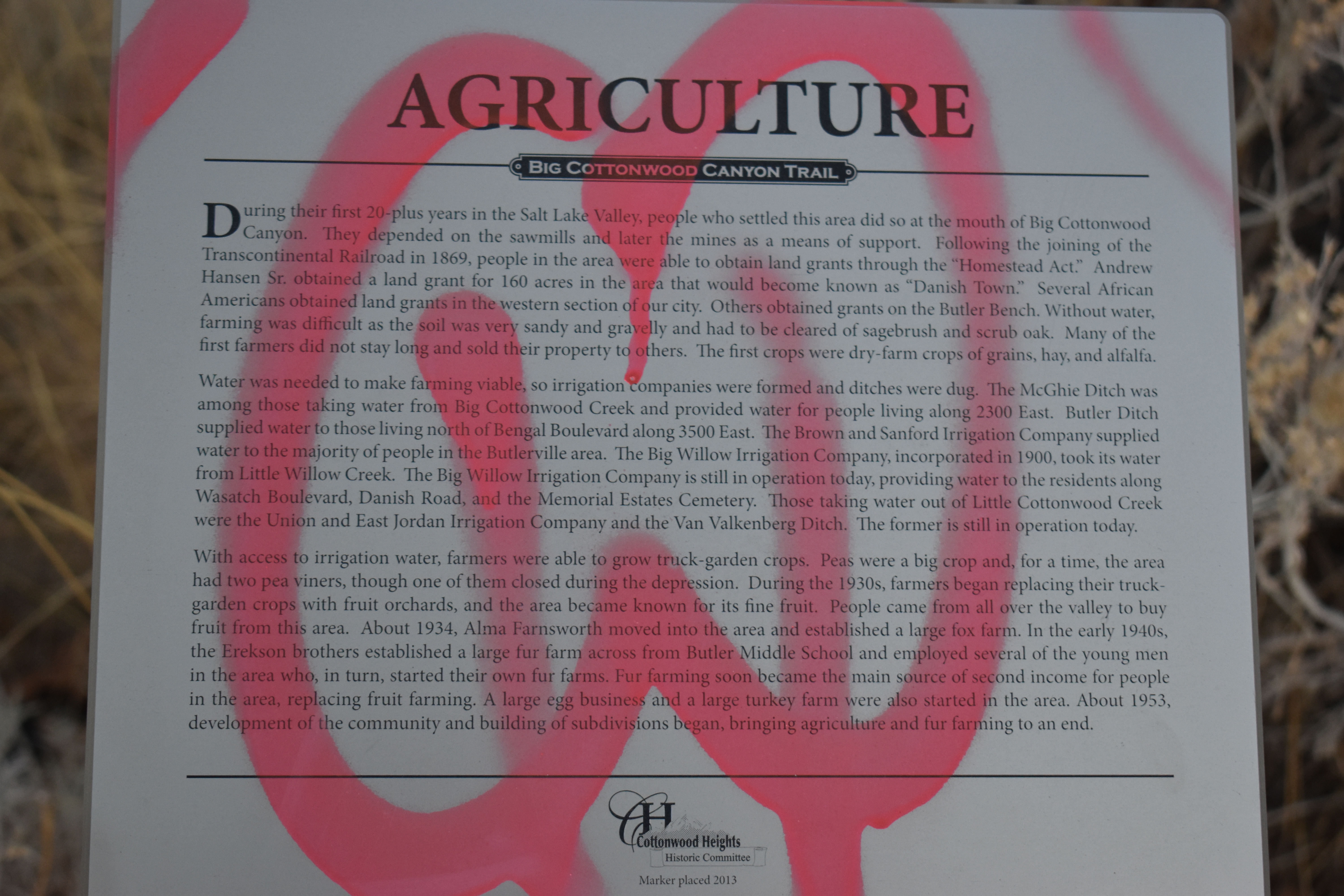
This sign has, sadly, been tagged. But it talks of the struggles of agriculture in the area, with lack of water, and very sandy soil, and how they over came that by building waterways. Eventually were able to move to fruit trees, and then to fox fur industry. Development of the area began in 1953 and farming soon ceased.

Leaving Historic Butler. I guess we would be entering … what is now Holliday?

Little forested section.

A copy of the historic walk sign that is at the top.

My pedometer app pinged 1.5 miles just as we started reaching the businesses along 3000 e. We decided a good round 3 miles was a good goal for the day and turned around. The last segment involved walking behind these businesses and across 3000 e, and more businesses until you reach i215. We’ve done it. It’s not the most thrilling, so, this was good enough.

Twin Peaks again.

Back to the covered bridge.

Dry creek bed.

I just adore this owl ornament on the trail side Christmas Tree. I might come back in January and if it hasn’t been reclaimed…. well it’s litter at that point and I am just cleaning it up.
Back to the old mill.

Hrm. Think I might have found the painted stone culprits. Not cool JE Cosgriff class of 2021. Shame on you.

The old mill again.
BTW, if the trail isn’t doing it for you, there is a bar just across the way called the Hogs Wallow if you want to stop in for a beer.

Walking along Big Cottonwood Canyon Rd.

The mountains again.

Fall meets winter. By this point, I am pretty sure the leaves are dead, just haven’t dropped yet.

Enjoying the newly paved section.

Another forested section.

I don’t recall this trail split leading to the west side of Wasatch Blvd last time. Doesn’t mean it wasn’t there though.

Back to Wasatch Blvd.

A look across the valley.
This isn’t the prettiest trail in the world, but I enjoyed the journey through the history of Cottonwood Heights. I also enjoyed solving the mystery of the ‘welcome to historical town’ signs I have seen through the area. I also enjoyed the improvement to the trail over the last time we did it. But still, it is mostly a stroll through neighborhoods, so I am going with 5 out of 10 squirrels again.

As for difficulty, it is now completely paved, and mostly a gradual climb, with a steeper incline towards the top. DR2.
Dogs are allowed, but must be leashed.

No comments:
Post a Comment