.jpg)
I am not sure when, or why this has been named Alien Tower. Judging by a nearby trail called Telegraph Hill I deduced this to be an old Telegraph tower. I could be way off though. Considering the telegraph technology started to decline in 1920, I would wager this tower to be at least 100 years old. This is all guess work, I truly do not know.
I’ve been wanting to do this trail for a little while now, I have just been wanting to wait for a not so hot day to do it. Considering the high mountains got some snow over the weekend, I thought this was a good choice today.

Quick Details:
Length: 2.7 miles for the balloon with spur, or you have a 2.6 mile out and back option.
Trail Type: Balloon with spur, or out and back.
Difficulty: DR3. A couple steepish sections, but overall it is pretty easy going.
Elevation Gain: About 500 feet.
Restroom: Currently there is a porta potty. I don’t know if it is there all year, or just in summer though.
Dogs? Yes! partial off-leash. If you want to take advantage of the off leash section, be sure to pay attention to signs and only do it when allowed, and be sure to re-leash where needed.
To Get Here:
Take exit 288 for 14600 So, 0.2 mi Keep left at the fork, follow signs for Draper, 420 ft Take Traverse Ridge Rd, turn right on Deer Ridge Dr . Take that to the end take the old dirt road over the chain.

Lone Peak (Passenger Seat Photography (PSP)).

I selected this trail today because I didn’t want to climb up into the canyons with recent snow (PSP). No show, but it was still a fairly steep climb up a canyon.
The Trail:

The trailhead. You want to go over the chain and head up the dirt road.

Lone Peak again.

And an interesting angle of Mt Timpanogos and Provo Canyon.

Quick panoramic.

Telegraph Hill Footpath. This is not the trail you want. If you start heading downhill you are on the wrong trail. However, this is what lead me to believe this is Telegraph Hill and thus a telegraph tower.

Closeup of some sage.
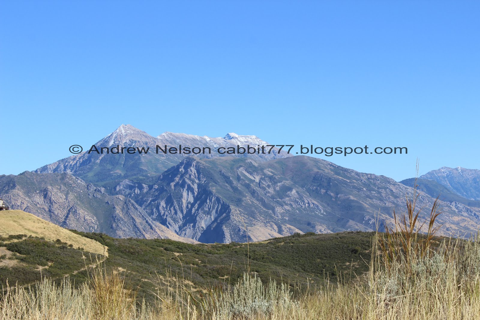
Another view of Mt. Timpanogos.


Once you cross the fence you are in the Off-Leash test area. Be sure to follow the rules so you can help ensure keeping the area open to dog walkers.

Pretty easy going trail with lots of sage.

Huge mountain bumble bee enjoying the sage. You know, this year has been the year of the bees for me lots of neat shots of them.

You can just make out the tower on that peak to the left. Uhm… that seems longer than a little over a mile. o.O
Turns out I am terrible at gauging distance as it was just over a mile to it.

A little closer.

View into the Salt Lake Valley. I’ve said it before, and I will say it again. Antelope Island looks weird from this angle.

View into Utah County with Utah Lake to the left.

With some sage.

I love trails that follow old dirt roads.

Little bit of fall peaking through.


At about 4/10ths of a mile look for this trail split. This is the most direct route, but as we learned on the way down, the other way gets there as well. Looking back, I think this way has some steeper spots with some flat breaks, where as the other way is more gradual, but constantly up.

Lighter steeper, but not bad.

Okay, quite a bit more steep.

And rocky!

I still can’t get over this different view of Mt. Timpanogos! Provo Canyon looks about as severe as I would expect.

Another panoramic. Utah county to the right, Salt Lake to the left.

A look into the canyon below heading towards Alpine.

Another patch of color.

Short, squat lizard. I wonder if this is a specific type of lizard, or just a young one.
I browsed the DWR reptile guide and the closest match I think is a greater short horned lizard. But, I don't know for sure.

Another one. The markings on the back of this one match, so I think I correctly identified these guys.

Some wildflowers hanging on.

Oi. Another climb.

There was a trail split here, and we chose the path to the right. Left would have been just a smidge shorter. I was happy I had the map up on my phone as there is a whole mess of trails up here. But, ultimately, keep to the main, wider looking trail and it should get you there. The alternate path is probably less confusing than this one.

Swinging back left at the top. Yeah, the other trail would have been a bit shorter. As we passed by on the way. Probably only 20 feet or so though.

The tower still seems more than a mile away, but it was not.

Still a nice wide path and a little break from the steep climbs. A runner that passed us below confirmed this was a loop.

There were quite a few butterflies up here today. Sadly the only one that I was able to get a picture of has been severely injured.

Looking back towards Lone Peak.

At the southeast end of the loop you will see this major trail split. This is the spur trail that will take you to the peak. (note, no wooden fences).
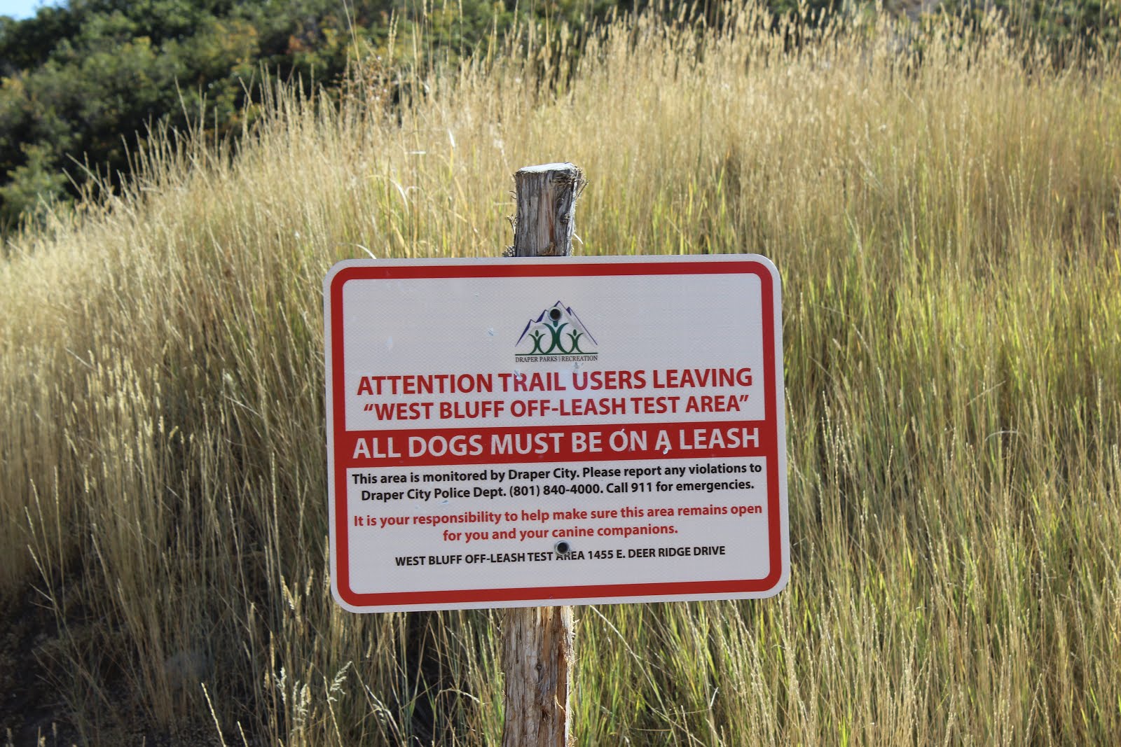
Take note, you are now in a leash required area. Please help keep the area below off-leash friendly by following the rules and leash up your pup!

We can see the tower above! Okay, maybe it doesn’t seem so far away.

Little bit more of a climb.

Another steep segment.

Some more color peaking out.

The peak above again.

Dry Creek between Lone Peak and Box Elder Peak. There is an excellent trail to Horsetail Falls in that canyon.

Entering open space. I am pretty sure you stay in Draper, and Salt Lake County throughout the entire hike, unless you decided to keep going.

Entering some thicker scrub oaks. There were reports of a porcupine up here so I was keeping an eye out for that. I've only seen a porcupine twice.

Oi. This spot kind of sucked, but not too bad.

Lone Peak and I think that is Corner Canyon below.

Wow. It is kind of neat to see the mined peak from the backside. You can see it from the Jordan Narrows.
I just went through that post to see if I could see this peak we are climbing, and if you can, I can’t pick it out.

I love the vibrant purple daisies along this trail.

Great view of Utah Lake.

Salt Lake Valley.

Getting closer.

I like this shot of Lone Peak.


Almost there! Trust me, it looks a lot worse than it is. I am really sensitive to heights and steep slopes, but this was not even remotely scary.

A closer look into Dry Canyon.

Final push.

Onto the peak! There was a nice couple who wanted their picture with the tower, and they took ours for us in return.
.
This is a very wide peak, like Ensign Peak so again, not anything to worry about. I’d bring my kids up here and not be too worried.

Of course I was fascinated with the old tower.

From underneath. I wanted to get a shot from the direct center, but there is a little hole there (I imagine from old equipment) that is filled with water, and well, the there are a lot of wasps in it and I really didn't feel like getting stung.

With the Salt Lake Valley behind.

Utah Valley. As you can see the trail continues down the other side, so I think you can get here from that side as well, but I don't know what that trail is like.

Lone Peak to Utah Lake.

The west side of the lake.

The tower again. We wandered all over the peak taking in the views.

You can get a full view of Utah Lake if you find the right spots.

The tower again.
With Utah Lake in the background.

Panoramic.

Little pond down in Alpine.

You can see all the way to Spanish Fork Canyon.

Utah Lake again.

The tower with Antelope Island.

Lone Peak.

Panoramic of the Salt Lake Valley.

I was having a blast taking in all the views from every imaginable angle, but we decided it was time to head back.

Lizard!

Heading down the ridge. Nice and wide.

Smaller peaks below.

I wonder what this puff ball looking plant is.

Looking back up at the tower.

Utah Lake again.

Some more fall color.

More pretty purple daisies.

There is a side trail up to the lower peaks I posted above if you still have some extra energy to burn out. I might come check these out some time.

Some more color peaking out.

Back down to the main loop. When we started this trail, we had planned the out and back route, but when we got here we decided to check out the rest of the loop, figuring it can’t be much longer (which it wasn’t).

View going down.

Another side trail. I am not sure where it leads. Note the fence on both sides, in case you come up this way, this is not the trail to the tower.

Heading down a little hollow.

Wild game trails.

View into the Salt Lake Valley.

Again.

More sage.

Random fire hydrant?

Looking back up the trail we just came down. Like I said, it appears to be a longer, more gradual climb than the side we went up. Now that we have done the full loop, I think if I return I will come up this way and see how it is.

Back to where the trail split for the loop.

Thistle.

Mount Timpanogos again.

Looking towards Telegraph Hill again. It really seems further away than it is from here.

Some kind of raptor hunting.

So between the fire hydrant, and some sewer line structures we saw, we determined that this must have been a development that failed. We assumed that what normally happens here, is that the developer ran out of funds and abandoned it. I did a little googling, and from a few news articles I have found it seems Draper demanded more trails and open space, and the out of state developer gave them a big middle finger and abandoned it. Then local Zions Bank took over and Draper still held firm to the open space demands, Zions tried to sue, and failed. Most recently it seems Draper decided to open it up for development again and the people raged. They wanted to make it open space and let the county control it and maybe build a restroom but, If I understand it correctly, now it is open for development, but at minor density. So currently no developers want to touch it. I really open the area stays open as is.

Another view into Utah County.

Salt Lake County again.

Most of the sage up here is orange, but these and a couple other bushes are yellow.

With a butterfly.

Nearing the end.

Heads up for dog people, dogs must be leashed for the last tiny bit.

Back to the trailhead.

I know the Telegraph Trail heads down from here, but it was not immediately clear where.

Better shot of some thistle.

Some of the sunflowers that seem to be growing along pretty much all of our roadsides.

A final look into Utah Valley as we headed home (PSP).

The road up here is surprisingly awful for such a ritzy area (PSP). I guess that was some of the fallback from the failed development deals.

Neat water tower (PSP).

Potato Hill (PSP). This has been on my radar for a minute, I thought about checking it out today but we decided food was more important at the moment. If I remember right, it is a shorter trail.
I absolutely loved this trail! It was not quite what I was expecting, but it was amazing! I had it in my head this was closer to the point of the mountain and was expecting something a little more flat, but obviously that was way off. The trail definitely has a climb, but it was not bad at all, and I enjoyed being able to hit another low peak with a very interesting tower to enjoy as well. We only ran into a couple of people, and had the peak to ourselves for quite a while. Going with 10 squirrels out of 10.
As for difficulty, I thought it was fairly easy going, but there are definitely a few sections that are a bit of a steeper climb. So, I think I am going to bump this one up to a DR4.
Dogs are allowed, leashed for part of it, and unleashed for a part of it as well. Just watch the signs.

No comments:
Post a Comment