.jpg)
This section of The Jordan River Parkway was surprisingly wild for the most part which made for a lovely walk with great views of the mountains.
Quick Details:
Length: About 3.2 out and back.
Trail Type: Out and back, Connector
Difficulty: DR2 Mostly flat and entirely paved.
Elevation Gain: NA
Restroom: It looks like there is one in General Holm Park, but I don’t know if it is open in winter.
Dogs? Yes, leashed.
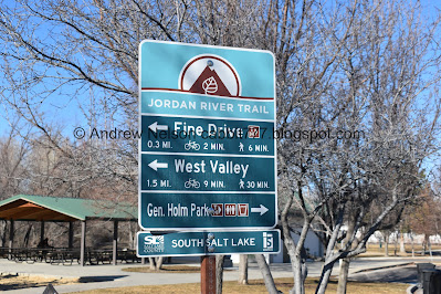
Other Info: Cities: Taylorsville, South Salt Lake. JRP Mile Markers: 30 and 31.
To Get Here:
Oh boy I sure am glad I used google maps cause I would have been in trouble. I thought the WW2 Memorial Park could be accessed from 45th S, but no it is gated off. So:
If coming from the north, take i15 to 4500 S, go west. Turn left on 500 west. Take that to Murray/Taylorsville rd (4800 s) go right. Take the first right (which is right after crossing the river) on Sunstone Rd. for 3/10 of a mile. Turn right on Bridgestone Wy. Go about 2/10ths of a mile and turn right on Mackinac Dr. About 1/10 mile later you will see a parking lot. Park near the opening in the fence.
If coming from the south, take the 5300 S exit. Go west, turn right on Murray Blvd. Turn left on Murray/Taylorsville rd (4800 s). Take the first right (which is right after crossing the river) on Sunstone Rd. for 3/10 of a mile. Turn right on Bridgestone Wy. Go about 2/10ths of a mile and turn right on Mackinac Dr. About 1/10 mile later you will see a parking lot. Park near the opening in the fence.
The Trail:

The road leading to 45th South is gated shut. Again, I am happy I had google guide me today.

Opening in the fence.

The river.

Passing by the WW2 Memorial Park.

Tunnel going under 45th South.

Mile Marker 30.

This short section is behind a rather large apartment complex.

The river is largely obscured by the foliage through here, but there are a couple spots it opens up a little. Hello duckies!

River again.

The mountains.

I was kind of excited to see the Big Cottonwood River Confluence, but uh. Damn. Its hard to see it through the foliage and well, it doesn’t look all that great. I hope this is something they plan to address one day. Or am I the only person that likes river confluences?


After the apartment complex it’s pretty wild. Aside from the random piles of cement pieces.

Forested area.

Mountains.
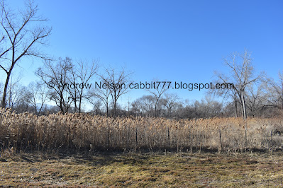
Swampy area.

More lovely forest.

Well, this was an unexpected find.

I was pretty sure this is a horse but some of the features seem a bit off. Maybe it’s a youngin?

Looks like there is a farm back there, so I don’t think this guy is lost.

Well that was fun. Bye buddy!

Riverbend.

The river.

Looking back towards the mountains.

American coot.

The river and mountains.

Again.

Mile Marker 31.

I guess we are entering an unincorporated area. Or the next city didn’t spring for the sign.
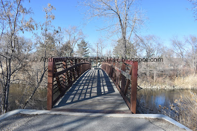
Bridge.


After the bridge I was met with a split that confused me for a second. Left seemed to be the way to keep going forward, but was not paved. Right seemed to head the wrong way, but was paved. Ultimately, I decided to go towards the paved path to the right, which was the right choice. Left appears to possibly get you there as well, (and may be the original path) but then you have to figure out how to get across the very busy 40th south, so I don’t recommend that.

Woo. I guessed correctly. It loops back around leading to a bridge over 40th south.

Crossing over 40th.

Entering South Salt Lake.

Where we have reached General Holm Park.
I pushed on to a good starting point for next time.
I went back and forth about adding the next section as it is a mile, but that would have made this a 5 mile trip, which is doable, particularly on this flat paved trail, but meh. Wasn’t up for it I guess. So, I turned around here.

One last look towards the next section.

Crossing back over 40th.

Mountains.

It looks like they MIGHT be working on building a trail on this side of the river. The sign there says it temporarily ends in 1800 feet. So, I am just guessing they haven’t gotten very far. But that would be a cool loop option. Or it is entirely possible this is just a neighborhood connector. I could not find anything to confirm or deny this idea.
Either way, I thought it would be wise to just go back the way I came.

Crossing over the river again.

Great view of the river and mountains here.

Re-entering Taylorsville.

Nice view of the mountains.

Mile Marker 31.

I just noticed they installed the word ‘river’ backwards on this one haha.


River and mountains.

Mountains and power lines.


I wonder if these islands normally exist, or if they are only showing with the river being extremely low.

River and mountains.

Pretty woods.

There really are quite a few scenic spots on this section.

Approaching the apartment complex, and thus the busier part of the trail.

Back to the Big Cottonwood Creek confluence. I really hope they improve this part one day.

Mountains.

Panoramic.

I like the way Mount Olympus looks here.

Spotted a great blue heron. I accidently startled it off by stepping on a twig, so this was my best shot.


A pair of pretty geese.

Not sure what this is. Probably overflow from the canal above.

Short section next to 45th south.

Looks like there was a fire here.

Back to Mile 30.

Quick short detour to photograph this neat bridge. If they do eventually make this a loop this would be a good spot to connect on this end.

Heading back under 45th south.

The river. Looks like it is at least a foot below normal levels.
The low head dam up river looks like there is no water flowing over it, so I wanted to investigate. I did not included this extra bit in the mileage today.

Looks like they are trying to catch debris here.

Seriously, what is going on? There’s no water going over the dam.

Oh, it looks like they have diverted the water to one side.

They also built a secondary dam behind it? I wonder if they are either removing the low head dam (which is super, super dangerous) or if they are just modifying it to be safer.

Here’s what it looked like a few months ago from our trip from Arrowhead Park to the WW2 Memorial Park.

Up stream.

Really curious as to what exactly they are doing.

Even with the river at seriously low levels, that is quite the output, and does not appear to be any safer than what was already in place. However, it does appear to be a work in progress, so I will wait to see what becomes of this.

Downstream.
I actually really enjoyed this section. It was an unseasonably warm day, so the trail was a little busier, but it wasn’t too bad. The section next to the apartment complex was kind of meh, but afterwards it seemed pretty wild and enjoyable. Not to mention several spots with pretty spectacular views of the mountains. And hopefully seeing some interesting improvements to the area coming soon. Going with 8 out of 10 squirrels.
As for difficulty, it’s mostly flat, with a mild climb up to the bridge over 40th south and completely paved. DR2.
Dogs are allowed, but must remain leashed. Please help keep this trail dog friendly by following this simple rule.

No comments:
Post a Comment