.jpg)
Twin Lakes is an absolutely beautiful reservoir located above Brighton in Big Cottonwood Canyon. The trail features some nice mixed forest, wildflowers, wildlife, an amazing viewpoint and finally a beautiful lake surrounded by majestic peaks. The short trail is a bit steep, and quite rocky, but it is absolutely worth it. So much so that we tend to do this one fairly often.
We tried to do this last week, however the boardwalk reconstruction project at Silver Lake closed the trailhead. Luckily it has since reopened and as a fun bonus we got to check out the new boardwalk.

Quick Details:
Length: It is about a mile from the back TH, plus about 3/10ths of a mile around the north end of Silver Lake so 2.6 out and back. We did about 3 with some extra exploring.
Trail Type: Out and back, loop options.
Difficulty: This is definitely quite the climb, and is quite rocky. DR4.
Elevation Gain: About 710 feet.
Restroom: Yes there are flush toilets at the Silver Lake Trailhead.
Dogs? No. Big Cottonwood Canyon is watershed.
Other Info: The Silver Lake boardwalk reconstruction project is still underway and you cannot complete the loop around Silver Lake. It looks like about 3/4ths of it is open as an out and back now.
To Get Here:
Drive to the top of Big Cottonwood Canyon. Start on the one way loop road through Brighton and look for parking on the right at the Solitude Nordic Center. There is more parking across the street. If both lots are full, you can continue around the loop road and park in the big Brighton lot, which will add about a quarter of a mile each way.

Entering Big Cottonwood Canyon (Passenger Seat Photography (PSP)).

The road side sunflowers are still going crazy (PSP).

Canyon cliffs (PSP).

I just love our canyons (PSP).

A particularly pointy peak (PSP).

A nice patch of pretty fall color (PSP).

Beaver lodge (PSP).

Continuing up (PSP).

This tree is getting an early jump on the color (PSP).

Same with this single aspen (PSP).

Nice view of Mount Millicent as we approach Brighton (PSP).
The Trail:

Sign at the Visitor Center confirming the trail is open. Yay!
PS, the trail is just to the right of the Visitor Center.

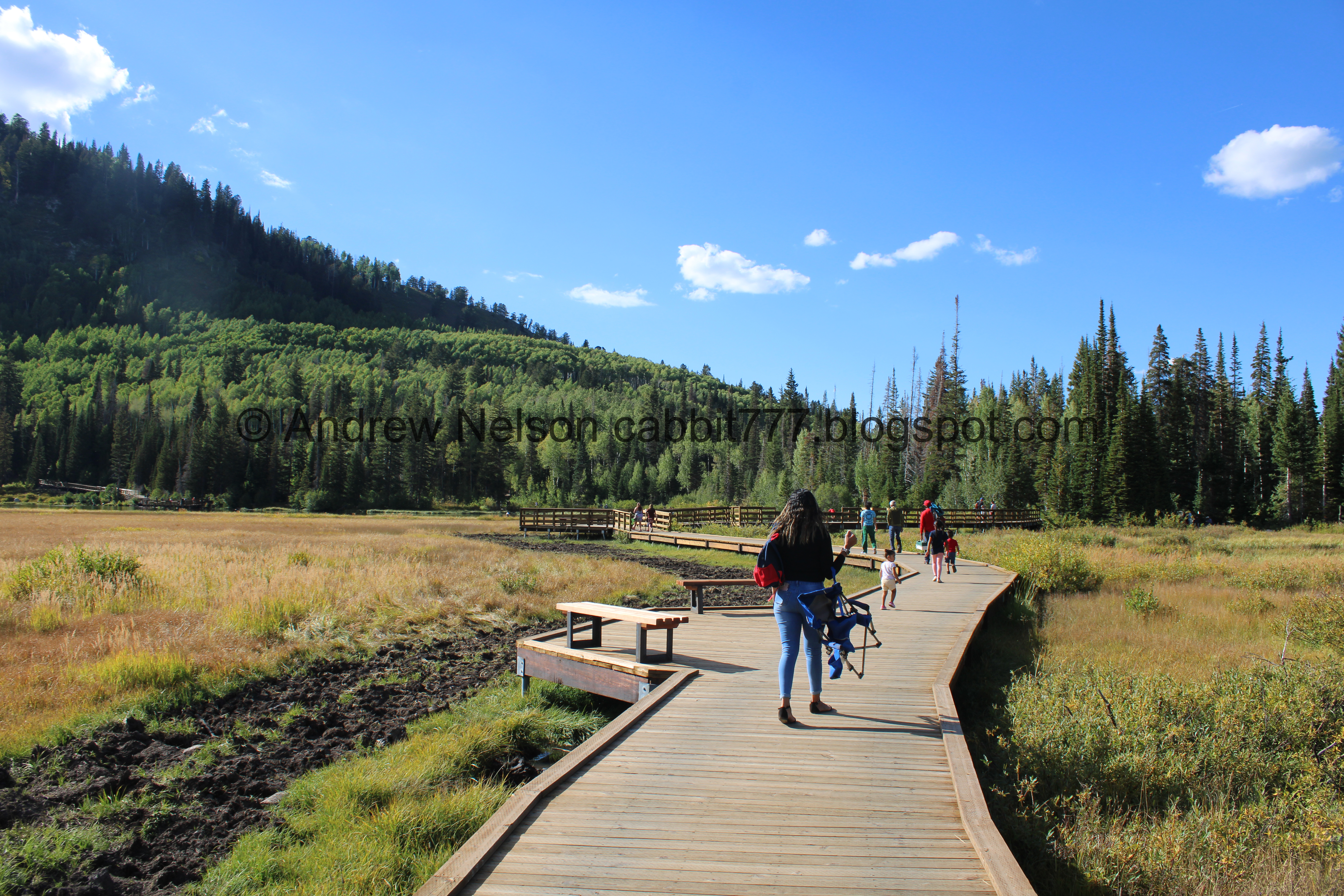
Wow, the new boardwalk looks great! Even if it is very crowded. Nice bonus, it smells incredible! I guess I just like the smell of new wood.

It looks like it did not follow the original path exactly. Wonder how long that old scar will take to grow in.

Here is what this part used to look like.

Mount Millicent and an, as far as I know, unnamed peak to the right. Twin Lakes lies between them.
More boardwalk.

Whoa! I thought the new bridge looked bigger.

Expanded seating area.

New bridge with enhanced fishing areas.

As many pictures as I take, I could not find one of the old dock, except for this one from above. I do generally try not to take pictures with people in them, so that is probably why, but I am a little sad I don't have one.

It still offers the same nice view and… is that a new beaver lodge? Or just a rubbish pile?

Downstream, with an existing beaver lodge.
Upstream again.

The last of the bridge.

You can make out Silver Lake back there. As well as the unnamed peak above. Before long we will be walking through that scree field in the middle of it.

Mount Millicent.

This little dock is new.

Nice forest.

Early changers.

Mount Millicent and Silver Lake.

About 3/10ths of a mile later we have reach the back trailhead.

It looks like they dug it up a little. I guess that is why it was closed last week.

They also dug out this little side area. I wonder what they plan on putting in here?

Pretty aspens.

The 4 way split. right is a closed trail, that I suspect is only used in winter. Forward leads to Lake Solitude (also a nice hike) and left will take us to our destination, Twin Lakes.

The old trail sign.

The underbrush is sure getting a jump on fall.

Heading up the rocky trail.


Pretty aspen forest.

More rocky trail.

More aspens.

With some nice pops of yellow.

Little patch of mint.

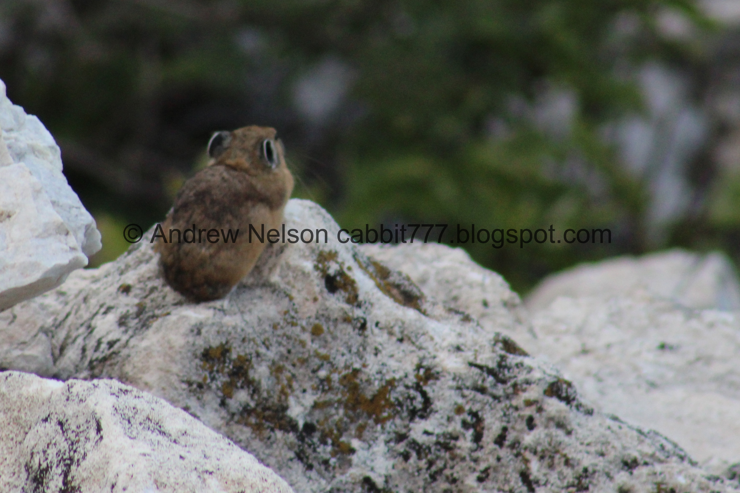
Before long we reached the scree fields. I often see pikas and marmots in here.

Speaking of, here is a cute little pika.

Crossing the scree fields.

Pika haystacks. Pikas do not hibernate over winter, so they spend the warm months gathering food into these haystacks to get them through winter.

The scree field. Pikas love these because they offer a lot of crevices to quickly hide from predators.

Looking down at the scree below.

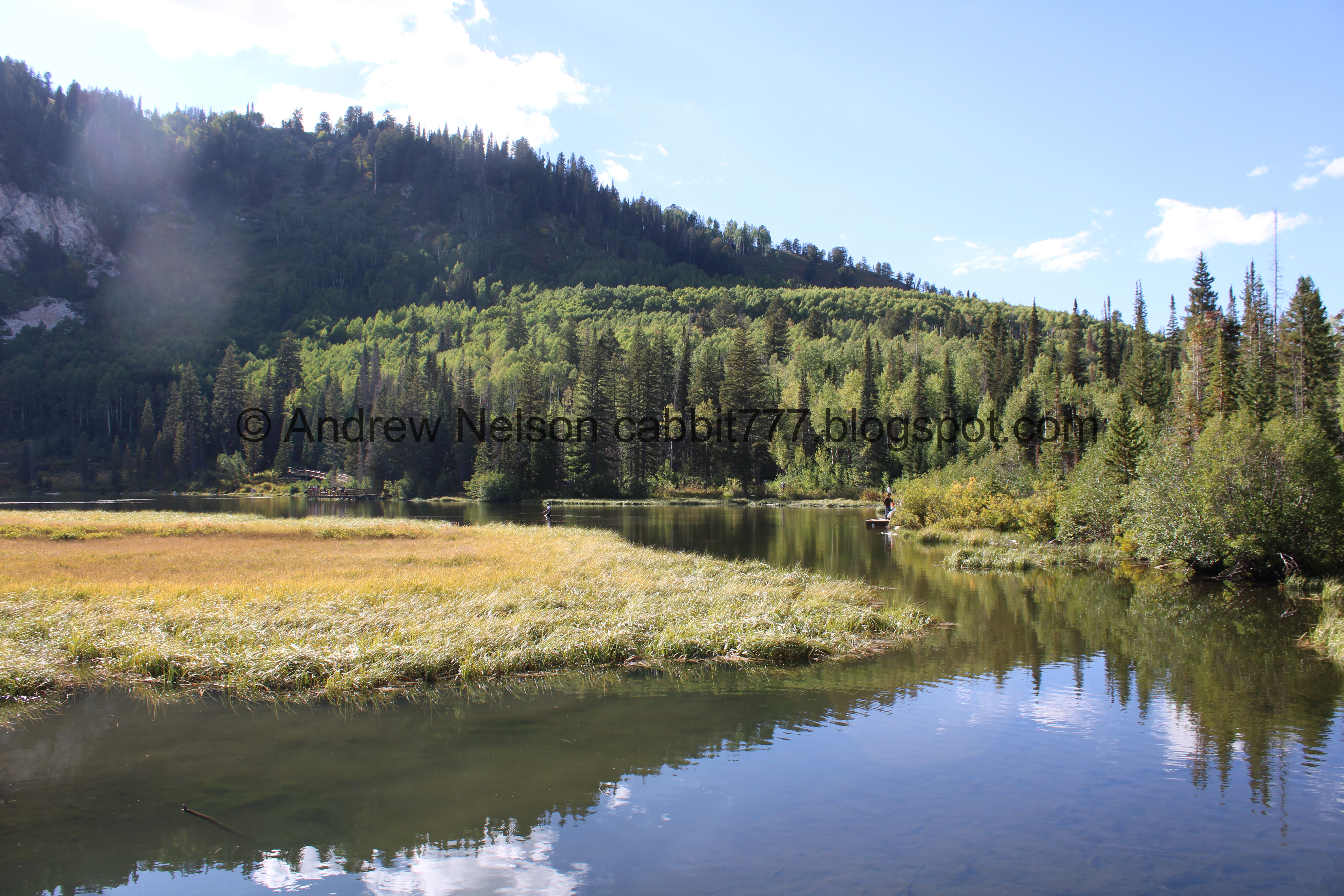
Silver Lake below. This is one of my all time favorite view points along the Wasatch Front.
.jpg)
Panoramic.

Little better view.
.jpg)
Another panoramic.

Again.
.jpg)
Another panoramic. You can see Guardsman Pass there towards center left.

Closer view of the lake. You can see the outlet towards the top, and the inlet to the right.

If you zoom in to the right you can see the new boardwalk construction on the south side of the lake.

The lake with Guardsman Pass and Scott Hill (easily identifiable by the Mickey Mouse shaped mine tailings).

Some daisy-like flowers.

Found a paintbrush still going strong.

Some plants getting a start on the color change.

More climb.

Another paintbrush.

After the scree fields you get a brief break from the climb. This is a great spot to catch your breath for a minute and happens to be about halfway.

Some sulphur flowers.

I am normally a huge rule follower, staying on the designated trail being one of them. This is the one trail I... bend that rule. The main trail is so rocky, it is really tough on the feet, ankles, and knees. There is a strongly established trail that parallels the main trail but is a lot less rocky, so I prefer to use it.

There is one section I prefer the main rocky trail, because the side trail is a little too steep and sandy.

Nice mix of flowers.

Some arnica growing out of solid rock.

Looks like some spent fireweed.

Oi. Still a bit more up!

Some more paintbrush.

Colorful hill.

Bumblebee on some daisy-like flowers.

Almost there.

Mount Millicent.

Cliffs.

First view of the dam.

The final push.

The dam below Mount Millicent, Mount Tuscarora, and Mount Wolverine.

Another nice mix of flowers.

Its the best photo I have of it, but they upgraded the float to a big tube for the overflow outlet. Landis wondered what it could possibly be for, my guess is to prevent debris from clogging the outlet.

Better view.

Huh, it looks kind of low right now.

Neat old driftwood, or a waterlogged stump I would guess is more accurate.

The Dam, Mount Millicent, Mont Tuscarora, and Mount Wolverine.
.jpg)
Panoramic.

The peaks again.
.jpg)
Another panoramic.

Nice clear water.
The lake again.
So why is this single body of water called Twin Lakes Reservoir? Well, before the dam combined them, there were a pair of lakes here called Twin Lakes. I got to see what that might have looked like a few years ago when the reservoir was particularly low.

Looking towards the back.

Not too far back there is a a nice scree pile with a little pika population.

This pika has a nice sheltered haystack.

A cute little pika.

Another. Super cute little guys!


Gathering some food.

This one also has a sheltered haystack.

Profile shot.

The lake through the trees.

The scree field again.


On the lookout.

The lake again.
.jpg)
Another panoramic.

The dam.

One last look at the lake before heading back.

The neat old stump again.

The cliffs.

The dam again.


More flowers.

View down and across the canyon.
.jpg)
Panoramic.

We followed our ears to the sound of rushing water. I guess this is the outflow from the reservoir. That comes down by the Millicent Chalet at Brighton, where it joins the collected output of lakes Mary, Martha, Catherine, and Dog Lake, on their way to Silver Lake. All combined are the headwaters of Big Cottonwood Creek.

Mount Millicent. It looks like this is the route down the service road towards Brighton, and the connector trail to Lake Mary. I have yet to do either of those trails, but maybe one day.

The spillway again.

Another spent fireweed.

Mixed flowers.

Okay, back down the trail.

Cliffs.

Daisy-like flowers.

Heading down.

Deer.

Colorful hillside.

Forest.

More daisy-like flowers.

Rocky trail with flowers.

More forest.

More patches of yellow.

Another view of Scott Hill.


Geranium leaves getting a jump on the color change.

Back to the scree fields.

Starting to see Silver Lake below again.

Paintbrush.

Silver Lake being a nice mirror at the moment.

Again.

Closer again.

Super pretty from up here.
.jpg)
Another panoramic.

The lake again. Inlet to the right, outlet to the left.
.jpg)
One last panoramic.

One last view of the lake. You can see they are demolishing the dock to the right. It will be interesting to see what it looks like when/if it is rebuilt.

The scree field again.
Pika.

Another.

Another haystack.

Another pika looking particularly regal.

More haystacks.

One last pika shot. We actually had quite a few sightings here, but I decided not to go too crazy haha. I love these guys, I think they are just adorable. Today I learned I am not the only one, as there were 2 photographers with much bigger lenses than mine chasing them around too.


Some more splashes of color.

Pretty aspens.

More color.

More forest.

Neat damaged pine in the middle of the aspens.


Colorful underbrush.

Found a geranium still hanging on.

Back to the 4 way split. Right will get you back to Silver Lake and the parking lot.

Looking up.

Back to Silver Lake. We thought we would see how the trail is progressing around that, so we continued to the right, knowing we would have to turn around eventually due to the construction.

They have smoothed out the trail some back here.

This new dock seems wider, but not as deep.

Still has a nice view of the lake though.
.jpg)
Panoramic.

Demolishing the dock on the other side.

They put pea gravel down back here. I’m not sure how I feel about that yet.

The lake again.


Well, this is different.

Beaver lodge.
.jpg)
Another panoramic.

Oh. They got rid of the small dock down here. That’s a little sad.

We got a little further around the lake than we had expected to, and there was still more to go, but we decided we were done. It looks like you can at least go to, and possibly through the wooded section on the south side of the lake, but will definitely have to turn around before the marshes again, for now.

The dock on the other side again.

The new dock again.

Neat hollow log.

The lake and Mount Millicent again.

The new small dock, with a lot less people.

It has a nice view too.
.jpg)
Panoramic.

The new bridge dock again.

Upstream.

Beaver lodge downstream.

The dock.

Mount Millicent.

New boardwalk and the scar from the old one.

Beaver dam.

I wonder if they plan on rebuilding the extra section to the parking lot.

Progress on the south section.

The beginning section next to the Visitor Center.

A Steller’s Jay.

Fun clouds above Scott Hill from the parking lot.

Closer.

Heading back down the canyon (PSP).


Some patches of color (PSP).

Storm Mountain (PSP).

Mouth of the canyon (PSP).

Somewhat of a sunset (PSP).
This is a little bit of a tougher climb, but it is so pretty that it is absolutely worth it. The large crowd at Silver Lake diminishes significantly on these back end trails. As I mentioned, I just love some of the views the trail offers, and I always enjoy seeing wildlife, even if its a little pika. The new boardwalk and fishing docks at Silver Lake are really nice, and smell great right now. Give it another week or so and the fall color should be popping. 9 out of 10 squirrels today.
As for difficulty, it is a non stop, rocky climb. DR4.
Dogs are not allowed in Big Cottonwood Canyon due to watershed restrictions. So be sure to leave Fido at home.

No comments:
Post a Comment