.jpg)
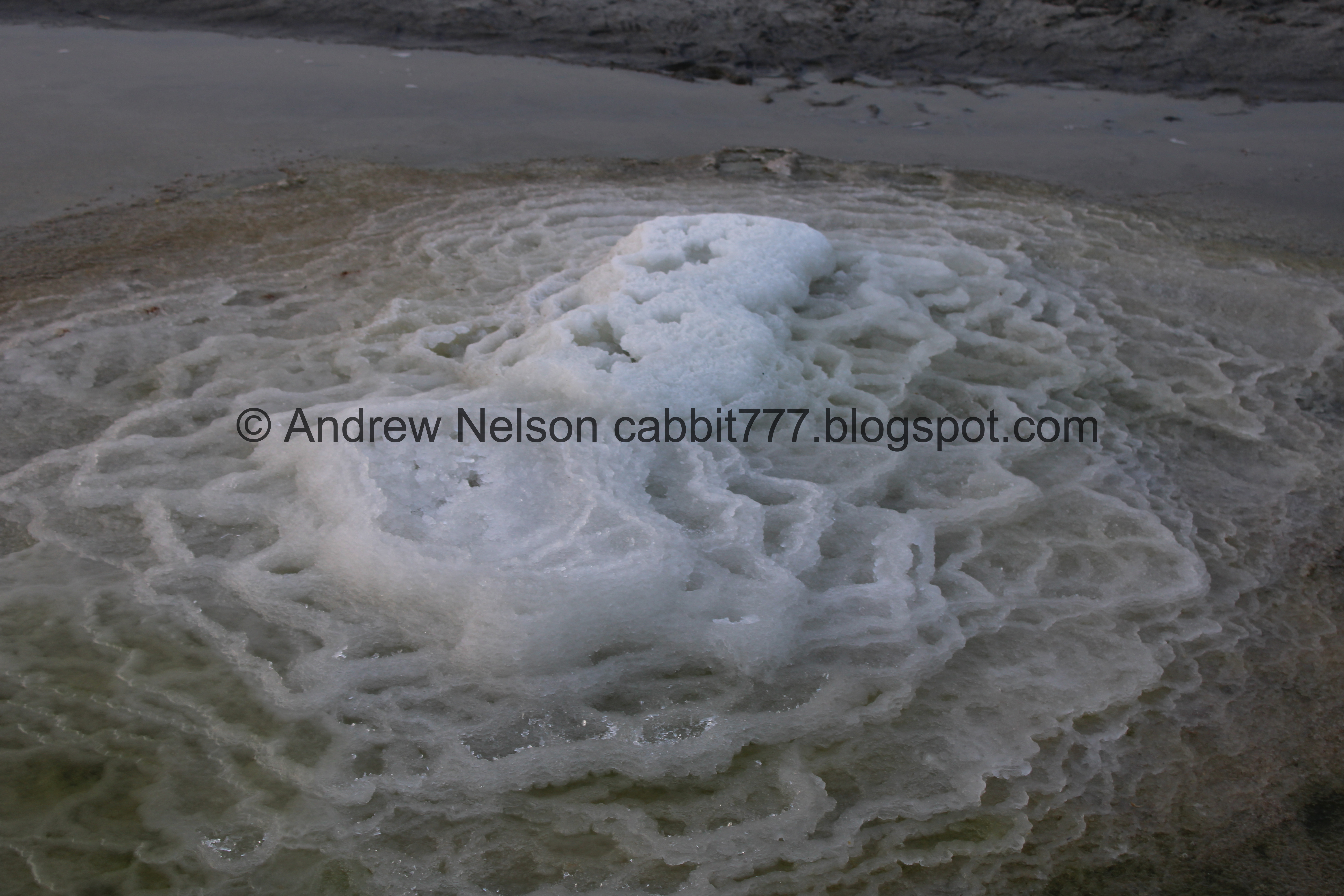
The “once in a lifetime” Mirabilite Spring mounds have returned to the Great Salt Lake State Park. These very rare formations only occur in very specific conditions which we happen to have here at the Great Salt Lake. I have come to see them at least once every year since they were discovered in 2019 because I just think they are really neat.

One of the mirabilite mounds.

Antelope Island from Silver Sands Beach.
Quick Details:
Length: The springs are only about 3/10ths of a mile out. We decided to explore more of Silver Sands Beach and did about 1.7 miles out and back.
Trail Type: Out and back.
Difficulty: DR3. It is fairly flat, but it is beach sand, and muddy.
Elevation Gain: NA
Restroom: Yes in the Visitor Center and near the park entrance.
Dogs? Yes, leashed.
Other Info: Fee area. $5.00 per car. Also, waterproof boots strongly recommended.
To Get Here:
Head east on i80 to exit 104. Turn right off the exit towards Saltair, and then immediately left (following the signs for the Great Salt Lake State Park and Marina). Follow that to the end. Pay your park fee’s and head in. Silver Sands Beach is accessed to the left (north) of the Visitor Center.

Mountains on the way out to the lake (Passenger Seat Photography (PSP)).

The new Salt Lake International Airport (PSP). The new artwork is bigger than I thought. We might have to make a trip out to see it closer sometime.

Antelope Island (PSP).

Random paragliders (PSP). I have seen paragliders in all sorts of places, but this is a first out here for me.

Saltair 3 (PSP).

The Kennecott smelter stack (PSP).

I have never noticed the K symbol on it before now (PSP).

They have completed paving the road (PSP). So, no more bumpy dirt sections.

Part of some new murals by the fee station (PSP). I thought I would come back to these, but it was too dark before I did.

The smelter stack again.

Quick stop in the Visitor Center.

Brine shrimp. Pretty much the only animal that can survive in the Great Salt Lake.
The Trail:

Silver Sands Beach. You can just make out some of the mounds towards the center here.

The trail is just to the left (north) of the Visitor Center and has a short hill down to the beach.

Antelope Island across the way. It’s kind of cool to be able to see a state park from another state park.

Saltair in the distance.

The smelter stack again.

Antelope Island again.

Crossing a wet area.

The sandbar we are walking along. It.. was not as prominent as it used to be. I guess the rough winter might have had a hand in that,


Holy dead birds, Batman. I am used to seeing dead birds along the shores of the Great Salt Lake, this is due the millions of bird migrating along the lake every year, and naturally a small percent of them die. However, the salt in the lake basically “pickles” them so they don’t rot as quickly and eventually make their way to the shores. But, even knowing that, holy crap, this seems like a whole lot more than I am used to seeing.

We made it to the mounds.
Incoming image dump…

One of the bigger mounds.

More mounds.
.jpg)
Panoramic. I can’t see them all here, but we counted 9 individual formations, some with multiple springs.

Another bigger mound.
So what is causing this? The quick version is that there is a layer of mirabilite AKA Glauber’s Salt a few feet below the bottom of the lake bed. The springs bring that up to the surface, and the cold air causes that salt to crystalize and create mounds. For more details see my first post from 2020.

A taller mound. I really love the formations these make. I say it every time, but they remind me of Mammoth Hot Springs. Instead of hot water creating travertine terraces, it’s cold water creating salt terraces.

Another mound.
So, a quick soapbox moment: these formations are very delicate. So please try to avoid walking on them. Also, the crystals are temperature based. If you try to take one with you, it will just dissolve into dust. So, aside from ruining it for everyone else, you won’t have anything to show for it so, don’t bother.

Another mound.

Another.

Back to the biggest mound.
.jpg)
Panoramic.

Incredible terraces.

The central spring.

More terraces.

Antelope Island again.

The central spring again.

Random boat. It was cruising super fast! Faster then I would have expected this close to shore.

Another mound.

Double mound.

Itty bitty mound. it’s so tiny it’s cute!

The smelter stack again.

Milky water pocket. Which also kind of resembles something you would see in Yellowstone, but I am certain this has very different reasons for the color.
Triple mound. I think this is the furthest west one.

The itty bitty mound again.

From the west, looking east.
.jpg)
Panoramic.

Another mound.

The triple mound again.

Terraces.

Double mound.

The smelter stack above some mounds.

The big mound.


Terraces.

The central spring.

More terraces.
.jpg)
Another panoramic.

More mounds to the east.

The smelter stack above a mound.

The big mound from the other side.

Terraces.

Starting to get a nice sunset.

Neat green pool.

From the other side.

Taller mounds.

Again.

Looking back towards the Visitor Center.


More mounds.

Another big one.

The smelter stack again.

The mound again.

Crystals.

Terraces.

From the side.
.jpg)
Another panoramic.

One final look before we continue our down the beach.

The smelter stack again.

Saltair. Our original plan was to walk out to that.

Walking across the beach heading towards the sandbar.

More dead birds.

Walking along the sandbar.

Some sunset.

The smelter stack again. Fun fact, this is the tallest structure west of the Mississippi.

There are a lot of wet areas to cross, at least this time of year.

Stansbury Island.

Antelope Island.

One of the few shipwrecks found in the park, currently the only one you can see that I know of.

Little closer.

The back.

Another little stream.

Saltair again.

The smelter stack again.

Stansbury Island.

Antelope Island.

We hit a really wet part.

Bird tracks.

More sunset.

The smelter stack again.

Ew…

Remnants of some old pier or something.

Nice reflection with the smelter stack.

Antelope Island again.

More sunset.

Antelope Island again.

It was starting to look like this might be the best sunset we get tonight.

Antelope Island.

Stansbury Island.
.jpg)
Panoramic with the 2 islands.

More sunset.

More bird tracks.

Oh I was wrong, we did get a bit more color in the sunset.

Saltair.

Another little stream.

The smelter stack again.

Antelope Island.

Well, we really did want to make it to Saltair, but we were rapidly losing light so we called it. I am guessing it was probably another 1/2 to 3/4 of a mile. Using google maps, I would wager it is about 1.5 miles from the Visitor Center. Oh well, another time.

Weird pothole. I see these on the beaches here all the time, I am still not 100% sure what causes them but my best guess is there was a rock, and water flowed excavating a little hole.

Ooh, some pretty color!

Little closer.

Stansbury Island.

Antelope Island.

More sunset.

Another stream.

More bird tracks.

The last of the sunset color.

More potholes.

The smelter stack again.


Lots of bird tracks.

More sunset.

Nearing the Visitor Center.

A stream and Stansbury Island.

Back to the shipwreck.

Another stream.

The smelter stack again.

Passing the mirabilite mounds again.

Looking back towards Saltair, and the lights of Salt Lake City.

Another stream.

Big patch of snow hanging on.

The little hill leading back to the parking lot.

Its nice to see the marina full again.

There is an easy to access viewpoint.

View of Antelope Island from it.

And Stansbury Island. I particularly like the lighting here.

Salt Lake City to the right, and Davis County to the left.

Fun giant compass.

The lights on the smelter stack blink, and I caught them in the on position.

A quick shot of the Visitor Center before we head back to the city.
We had planned our entire day around eating at a local burger joint so we took 201 back, and were sadly disappointed the place was closed. Craving burgers, we decided to revisit the Black Sheep as we knew they have good burgers too, so all was not lost. Just took longer to get there than it should have.
Anyway, I enjoyed our adventure today. A little sad we didn’t get as far as I wanted, but glad we turned back and didn’t walk back in the dark. We had the mounds, and well, most of the trail to ourselves today which was nice. Most visitors do not appear to know about the mounds and tend to stay near the main area. That will change when they start the tours in January. I am the weirdo that follows local state parks on social media haha. 10 squirrels for the mound, 8 for the rest of the beach, so we'll split the difference at 9.
As for difficulty, it is mostly flat with a short hill at the beginning, but walking along the beach can be a bit tough as the texture and consistency of the sand changes pretty drastically pretty often.
Dogs are allowed, but should be leashed. Some extra caution should be extended around the spring mounds to ensure your pup does not damage them.

No comments:
Post a Comment