.jpg)

Quick Details:
Length: The guide I used said 2.11 miles out and back, but we did 2.5 and didn’t go to the end.
Trail Type: Out and back.
Difficulty: DR6 this was a tough climb! And had some rough creek crossing.
Elevation Gain: 1010 feet, we did 925
Restroom: No
Dogs? They are allowed but I wouldn’t bring them.
Other Info:
To Get Here:
Take i15 to exit 351 toward US89. Stay left to merge onto 89. go 4.7 miles and turn right onto 300 N. (visual marker is the Willard Creek Spillway on the south side, and the Pioneer Cemetery on the north side). Go about 3/10'th of a mile and take the right fork, park. Alternate trailhead will take the left fork.

Neat little cave (Passenger Seat Photography (PSP)).

Another little waterfall we passed on HW89 (PSP).
The Trail:

The main trailhead.

The creek. We probably could have crossed here and been okay, but I didn’t want to have wet shoes the entire trip. I thought I remembered seeing a road that went into the canyon, so we went back to the other TH. This will add just a little bit to the hike, but not much.

View of the canyon above.
The alternate TH is outside of the quarry and is accessed by taking the north fork on 200 N. If you get back to HW89 you missed it.

The sign states that the area is monitored, it does not say ‘No Trespassing’ so I think we are good passing through here.

Pile of rocks I presume is meant to stop cars.

Wait… this took us right back to where we just came from. What gives? I didn’t get a picture but just to my left is a thin trail up.

Then the trail goes through this scree field. It didn’t show up in the photo, but there is a definite defined flat path through here.

Willard Creek.

Then we have a nice mellow trail, for a minute.

A rather stunning dragonfly actually sat still for me.

Trail split. Go left here. we tried this trail once before and used the right split here, and well, we didn’t get far. Although, now that I think about it, they both kind of suck haha, but left is much more defined.

Now for the climb.

Lovely view of Willard Bay.

What. The. Heck. Is. This??? I thought it might be a cocoon, but that doesn’t seem right.

Main TH to the left, lower. Alternate TH right, upper.

Oh good hell it’s getting more steep! I struggled through this section but made it.


Beautiful purple flowers.

Alright, I think we’re past the worst of it.

Willard Bay again.

I generally am not a fan of trails on steep slopes, which this is, but it’s not too bad. And the sagebrush helps to hide it as well.

Looking down into the canyon below.
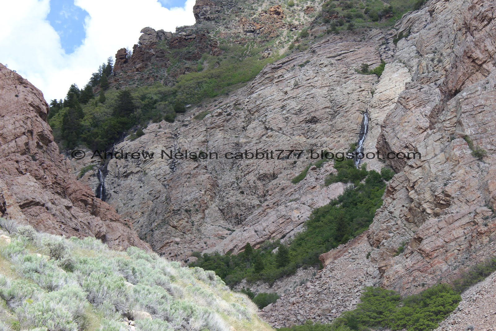
The canyon and the waterfalls again.

Another pretty purple flower. This appears to be a taper-tip onion.

Canyon below.

This trail is a little tricky because every time I think we are nearing the top, we crest a hill and there is more.

Pretty white flower.

Turkey vulture. I only tend to see these guys around this time of year near the canyons. I got some better pictures on the way down.

Waterfalls again.

More climbing.

The waterfalls.

I am not crazy, the road does come up this way!
From what I can tell you can take the road, for what I would assume a more gradual trail and it will only add about 3/10ths of a mile.

Looking back towards Willard Bay.

Little closer.

End of the road, back to trail.

More of the pretty purple flower.

Rocks above.

Getting close to the cliffs.

The waterfalls again.

Some pretty Indian paintbrush.

The canyon bottom is rising up to the trail level.

Pipeline.

Another scree field.


The creek again.

The southern waterfall.

The first bridge, while very sketchy looking, was cross-able. The other side bounced a little more than I would like though.

The creek.

Nice little waterfall.

The roar of this waterfall while trying to cross over this sketchy ass bridge kind of reminded me of Drift Creek Falls in Oregon. Not quite as intense as that, but same problem. Roar of a waterfall and a scary bridge. Which just kind of makes it harder.

2nd half.

The 2nd bridge o.O. I am sure it is fine when the water isn’t quite this rough. But with it being all wet we were both concerned about slipping and well, that is not a good spot to slip.

More of the falls.

There was a short scramble on this side of the creek so we thought we would check it out.

Great view of Willard Bay.

We did find a nice view of the southern waterfall again.

However to continue along though here looks like some sketchy boulder scrambling. Neither of us felt up to doing that either so, I guess this is the end of the line for us today. Darn. This was about 1.35 miles up.


Back down to the creek.

Landis crossing the sketchy bridge.

Back across the scree field. The trail is not as obvious through here, but is still pretty discernible.

Cliffs above.


I noticed a snake slipping across the trail.. and then noticed that rattle on the end. Holy crap, my first rattlesnake in the wild! I managed 28 years of my life without ever encountering one and well, that streak ended today. oi. But, it was kind of cool to see it, and thankfully not feeling threatened. Although it did make me feel all sketched out for the remainder of the trail keeping my eyes on the ground in case there were others.

Beautiful green trail.

More paintbrush.

Another scree field.

With the peaks above.

Another paintbrush. I love the color on these today.

Cliffs again.

View of Willard Bay again.

Looking back at the waterfalls.

Vultures again.


I decided to pull out my telephoto lens and finally got a view of the red head.

Another shot.
There were a good 5 - 8 of them circling here. Must have found a good food source.

Willard Bay again.

Some pretty wildflowers.

The canyon below.
One last view of the waterfalls.

The road and the trail. Now that I know the road was only about another 3/10ths of a mile I probably would have opted for that, but we decided to go down the way we came up.

Easy so far.

They appear to be burning phragmites today.

Another pretty onion.

Butterfly.

Pretty purple flowers.

The trail again.

Willard Bay again.

Back down to the steep sketchy section. Oi.

Another butterfly.

The steep section is a bit longer than I remembered. Oi.

Another butterfly.

The creek below.

Wild daisy's.

Willard Creek again.

The lower scree field.

You can see the worn trail better from this direction.

The canyon above again.

The creek crossing the road again. If you parked at the main TH this is where you want to go. But, if you parked at the alternate TH you have a little more to go.

Up to the main quarry.

Neat stone.

Quarry again.

Canal.

Willard Bay again.

Mountains to to south.

Willard Pioneer Cemetery is at the bottom of the street (PSP). We explored this last time we tried to hike this canyon and failed.

Some fun clouds we saw on the drive back (PSP).
That canyon is tough! But it is really cool to see the waterfalls as you hike up. I wish we could have made it all the way up, maybe one of these days I will try a little later in the year. It was a great choice for this holiday weekend as it wasn’t very busy. Just a couple other people. Lastly, I really could’ve gone a couple more years before seeing a darn rattlesnake! Although, that can happen anywhere so it’s not this trails fault. Anyway, 9 out of 10 squirrels. Removing 1 for steepness and sketchy river crossings.
As for difficulty, as I mentioned this was a long hard climb with a fairly long steep section. And the river crossings were really rough so DR5.
Dogs are allowed, but I probably wouldn’t bring them.

No comments:
Post a Comment