.jpg)
The Great Salt Lake State Park is a small state park located on the far western end of Salt Lake County, just off of i80. It features a marina, 2 small beaches, and camping opportunities. There really is not a whole lot to it, but it does offer an easy way for east/west travelers to quickly experience the lake. However, this year, for the 3rd year in a row, a very rare phenomena has shown up. Mirabilite Spring Mounds. I am absolutely fascinated by these so each winter, since they were first discovered, I have made a point to visit at least once or twice. We also checked out some of the other neat things you can find on Silver Sands Beach. Plus after yesterdays hike, I wanted something that was a little easier.
Quick Details:
Length: It’s about a half mile out and back, but we made a mile loop with other features for a total mile.
Trail Type: Out and back or loop.
Difficulty: Its beach sandy, and muddy, but mostly flat with a short hill. DR3.
Elevation Gain: Maybe ~20 feet.
Restroom: Yes
Dogs? Yes, leashed. But I would keep a close eye on them. We took our pups today, but had to be really careful keeping them off the formations.
Other Info: Fee area. $5.00 per car day use fee. Pro tip: You can pay online in advance. Also good waterproof boots recommended.
To Get Here:
Take i80 to exit 104. Head north. Turn left in front of Saltair. Continue down the narrow rd to the fee station.
Note: The road is mostly paved, but there are a few spots that are not currently paved, however they are flat and well maintained.

Decker Lake and the smog obscured mountains (Passenger Seat Photography (PSP)).

Antelope hanging out in the desert between the airport, and the state park (PSP). I worry about what might become of this herd if they build up out here too much.

Taking in the views (PSP).

With the lake being at it’s lowest level in 60 years, they removed most of the boats from the marina (PSP).
The Trail:

Silver Sands Beach is on the east side of the parking lot, to the left of the visitor center.

The Kennecott smelter stack. Tallest structure west of the Mississippi.


As far as I can tell this creek is unnamed.
Anyway, you want to cross it and follow the little sand bar east.

The smelter stack again.

This beach is weird. At least in winter.

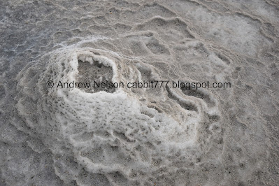
Before long we reach the mirabilite spring mounds.

Winter winds have covered the mounds in sand so they are not as pristine as normal. But they are still neat.

I made my way roughly clockwise. This is the biggest mound.

Smaller mound.

More mounds.

Fun terraces.

Another angle of the 2nd mound. Which I believe is the largest one right now.

Another angle. I've mentioned before that these remind me of the terraces at Mammoth Hot Springs in Yellowstone, but cold. But another big difference is how quickly these change.

Another larger mound.

Little one that looks like a volcano.

Itty bitty one.

Medium sized.

Another volcano.

Another larger one.

Another medium one.

A bigger active mound, since it is pretty clean.

Closer to the main spring. I just love all the little terraces.
I would love to see a time lapse of one of these going. Last year they had some camera on them, but I never did find any footage.

Another volcano looking one. It also appears to be active since it is clean.

This mound appears to be the most active, since it is the cleanest.

Dirty terraces.

Another mound.
I think I counted 16 mounds. With 3-5 of them appearing to still be active.


Couple texture shots.

Back to the active mound. Lots of terraces.

Closer.


Oh! This one has some crystals.

Oh wait, I think this one makes 17.
From the top. Oh, this one has crystals too.

Quick panoramic before we move on to the next feature.
I really just love these formations! They are super neat.

The Kennecott smelter stack again.

The sand bar we are walking along.

Looking back towards the visitor center with some nice clouds.

It is about 1.3 miles all the way out to Saltair, and you can even keep going I believe. But today we were after the old boat wreck you can see to the left, which is about 4/10ths of a mile out.

Its really weird not being able to see the mountains due to smog/fog.

Or Antelope Island for that matter.

The old boat wreck. There isn’t much to it, but it is neat. More info here.

Closer.

From (what I assume is) the front.

From the back.
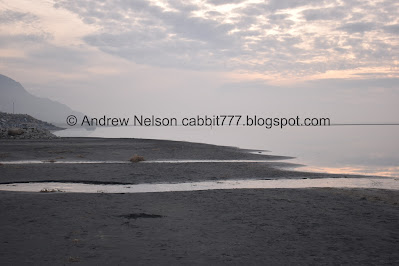
From here we decided to walk out towards the lake and follow the shore back to make a loop.

The smelter stack again.

Looking west towards the visitor center.


I’m still trying to figure out what causes these weird potholes.

With not being able to see the islands, the lake looks a lot like the ocean.

The smelter stack again.

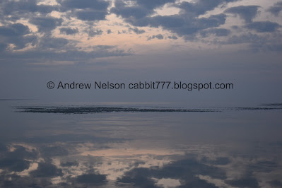
Wow! This is the most still, and mirror like I can ever recall seeing the lake.

So pretty.

With the lake as low as it is right now we can see the Great Salt Lake Coral. Which is not a true coral. It is an algae that builds bulbous sedimentary rocks call stromatolites. We’ll get a better view of it towards the end.

For whatever reason the pups were super interested in.. whatever this is. They pulled us over to get a closer view of it.

This was about as good of a sunset we were getting tonight. With the still lake, it is still pretty exceptional, but man, a glorious sunset would have totally rocked today.


Super pretty.

The stromatolites again.

Little stream joining the lake.
Couple more streams. And you can see Black Rock in the background. Which is at the end of Sunset Beach on the other side of the marina.

More pretty clouds.

I think this is the shot of the day.

Another good one. The stromatolites make a weird break, but still neat.

The smelter stack, and a bunch of cairns. I hate when Instagrammers build random cairns. Cairns are meant to be way markers. So the ones here used to piss me off. However, I have since learned this park encourages it as they provide living spaces for the orb weaver spiders. Little spider condos haha. One of these days I might come out during the summer and check out the spiders. I’m pretty arachnophobic, but I am also fascinated by them so in a controlled environment I might be okay. Maybe… haha.


More cairns.

Lovely clouds.

The little hill you have to climb.
After this we walked out over to the overlook.

You can see the stromatolites a lot better up here. I was kind of surprised there wasn’t even a temporary sign here about them. I know we can only see them due to the lake being at it’s lowest level in 60 years, but it is still an interesting little factoid. Which I learned from their Facebook page.
More.

Fun little compass built into the overlook platform.

It really is interesting all the random places you can find something erected, or dedicated around the time of the 2002 Olympics. I know it was a big deal, but 20 years later it’s mind boggling.

The marina.

I know it is a serious warning, but the imagery on it made us laugh.

The full “wolf” moon rising through the haze was a reddish color, before disappearing again.

On the way out we found a bunny!

Cute little guy.

All the boats that they have pulled out of the marina (PSP).

Saltair (PSP).

Fog settling in (PSP).
I really enjoyed our adventure today. After yesterdays steep climb, it was nice to have a an easier adventure, with some fascinating things to see along the way. It was not at all busy today either, which is another nice bonus. However, it was a bit of a longer drive for a shorter adventure. But still, 10 out of 10 squirrels.
As for difficulty, it is beach sand, and some mud, but mostly flat with a small hill. DR3.
Dogs are allowed, but must be leashed. Be sure to keep them off of the mounds.

No comments:
Post a Comment