.jpg)
The Wild Rose Trail is a great little trail system located in North Salt Lake. The lookout trail winds through some lovely scrub oak forest. What I primarily use this trail for is to get up above the inversion and see the layer of funk stretching across the valley. It is a little bit tougher, but it’s a little shorter.
Quick Details:
Length: We did about 1.8 out and back, but it keeps going if you want a little longer.
Trail Type: Out and back.
Difficulty: There were a couple steeper sections. DR4.
Elevation Gain: We did about 475 feet.
Restroom: Yes, closed in winter. However there is currently a port o potty for use.
Dogs? Yes, leashed.
Other Info: Micro spikes highly recommended.
To Get Here:
Take US 89 in NSL to Eagle Ridge Dr. Go up the hill about 2 miles and turn right on Eagle Point Dr. Turn left on Sky Crest Ln. and you will find a nice community park. The trailhead is up past the picnic tables.

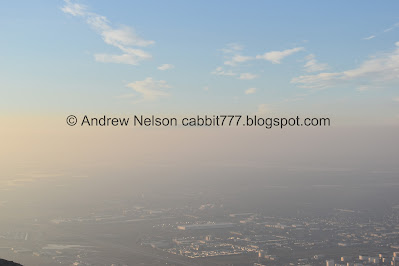
We can see the mountains, but they are quite faint through the smog (Passenger Seat Photography (PSP)).
The Trail:

Wild Rose Park. Head strait through to the back.

The trailhead is at the back end of the park.

Icy trail.

The little hollow we will climb up. There are a couple trails through here, but stay on the main trail that follows the hollow east.

Into the scrub oak.

At about 4/10ths of a mile you will come to this 5 way trail split with a bench. You are going to want to take the upper trail to the right here. The lower trail to the right is a fast downhill bike trail. Forward will take you to the Chukar Loop.

View from the bench. We decided we needed to put the micro spikes on before the climb really starts. Luckily the bench was pretty dry. From this direction you can see the 4 trails heading west. We will be take the far left trail from this vantage. The middle left is a fast downhill bike trail, middle right is what we came up, and far right is the Wild Rose Loop and the Chukar Loop.

Continuing up.

Signed for Viewpoint and City Creek Ridge.

Up through the scrub oak.
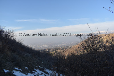
View down canyon.
There are a couple spots climbing up to the ridge that I don’t like. I mention often that my fear of heights makes it so I struggle on thin trails along steeper slopes. I’m not sure if it is getting worse, or adding the snow and ice multiplied it, even though I had micro spikes on, but it was rough today. But, I managed to push through it and get to the ridge.

After the switchback, continuing up.

Some hoar frost. This north facing slope does not get a lot of sun this time of year.


Up to the viewpoint. There is another bench here to enjoy the view. We are slightly above the inversion, but not quite.

On to the steepest part of the climb. Oi.

I swear it feels like it practically goes strait up! I definitely would not have attempted this today without the micro spikes.
Sometimes on these steeper sections I just have to power through to the end, and then collapse at the top and catch my breath again.

View from the top.

You can barely see the top of Antelope Island across the way.

Panoramic.

Back to the climb. After the last section though, this is a cake walk! Although, right now it is a little frustrating. You need the micro spikes for the ice, but there are some parts that are exposed, and it is a rocky trail. The micro spikes are awkward on the rocks. Short of taking them on and off again repeatedly (yeah that’s not happening) you just have to accept the rocky parts being a little uncomfortable.

Looking back down.

Nearing the next peak, there appears to be a new cross trail here.

Now we are up on the ridge, and its not so bad.

Nearing the top, of our intended destination anyway.

More hoar frost.

Trail Split. Left continues up along the ridge, eventually, I believe, leading to the City Creek Ridge. Right is my go to spot that offers a nice view of the valley, so, we went right.

The valley below.

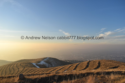
Ridges along the valley. I finally learned what these are! These are an effort to control erosion that the US Corps dug in in the early 1900’s.

Heading out to the small sub peak.

Davis County.

Salt Lake County.

There really isn’t a defined trail up to this peak, but its pretty straightforward.

Wow. This is insane!

Panoramic.
The very top of Antelope Island again.

Salt Lake County again.

Funk below, blue skies above.
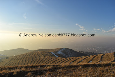
Striped hills and inversion.

Davis County.

The top of Ben Lomond off in the distance.

Another panoramic.
View again.

Salt Lake County.

Again.

Davis County.
Okay, well we got the views I was looking for we decided to head on back.

Striped hills. We considered making our way up to that little peak, but decided against it. Maybe next time.

We noticed a little shortcut. Probably only shaves off 1/10th of a mile or so.

Deer tracks.

Not sure if this is another pipeline scar, or some other clear cut scar.

Back to the ridge.

Another panoramic.

View below.

Heading down the steep part. Oddly, it doesn’t seem as steep going down as it did coming up. But, thank goodness for micro spikes.


More of the inversion.

Back down to the lookout.

Nice view from here.

The almost full ‘wolf’ moon coming up over the hills.

Icy trail along the ridge.

The nearly full moon again.

The inversion again.

Some hoar frost.

Back into the scrub oak.

Back to the 5 way split. We want to go down the 2nd trail to the left here. Or middle right as viewed from the bench.

More forest.

Leaf melting its way down into the snow. I don’t know why, but I love seeing this. It’s basic science, the darker colored leaf absorbs more sunlight and heat, so it warms up and melts its way down.

More forest.


View down canyon, with a hint of some sunset.

Fun pink clouds.
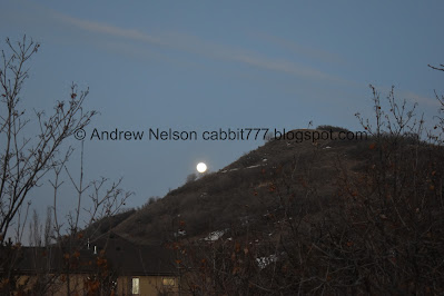
The moon again, from the trailhead.
This trail was a little bit tougher than I remembered it being, but we’ve been taking it a little easier for the most part lately due to a minor injury. Not a lot of people out here today, and getting up above the smog and seeing blue skies totally made the day. 9 out of 10 squirrels.
As for difficulty, there is a bit of a climb, and one steep spot. DR4.
Dogs are allowed but must be leashed.

No comments:
Post a Comment