.jpg)
Willow Heights AKA Willow Lake is a beautiful lake near the top of Big Cottonwood Canyon. It features a nice little lake, a creek, beautiful aspen woods, wildflowers, and a good chance of seeing wildlife. Both forks are a bit of a climb, and both offer fantastic aspen forest views. We enjoy this trail, and tend to do it several times a year.
It is supposed to rain through the entire holiday weekend. Which, we need the rain so yay, but seriously! I wanted to get an extra hike in. Anyway, we normally go Sundays but when it stopped raining and the sun came out we decided we better get out while we could!

Quick Details:
Length: The east trail to the junction is about a mile. The west trail is about 9/10ths of a mile, and the loop around the lake is 3/4 of a mile so the full loop is about 2.65 miles. We did the west route and around the lake today.
Trail Type: Out and back, loop, figure 8 or balloon.
Difficulty: DR3.
Elevation Gain: About 600 feet.
Restroom: No. Closest one would be at the Solitude Nordic Center at the top of the canyon..
Dogs? No. Big Cottonwood Canyon is watershed.
Other Info:
To Get Here:
Head up Big Cottonwood Canyon about 11.6 miles up, past the Silver Fork Lodge. About halfway between mile marker 13 and 14 there will be a boulder on the left (north) side of the road. If you reach Solitude you went too far, but don’t worry. the canyon ends at a loop that will easily turn you around.

Heading up Big Cottonwood Canyon (Passenger Seat Photography (PSP)).

My original idea was to revisit Mill B North but uh, my fear of heights was not having that one today so, we kept going.

It did offer this nice view though.

And a cool view of the S Curve.
So, after that failed I decided to see if there was not a ton of snow on the Willow Lake trail.

As we passed Mill D I noticed this moose. So we stopped to take some pictures.

Looks like a juvenile male, based on those antlers.

Someone with a death wish. Seriously, that is way too close!

Oh, there is a 2nd one!

One last shot before we continued along the way.
The Trail:

The Dedication Stone.
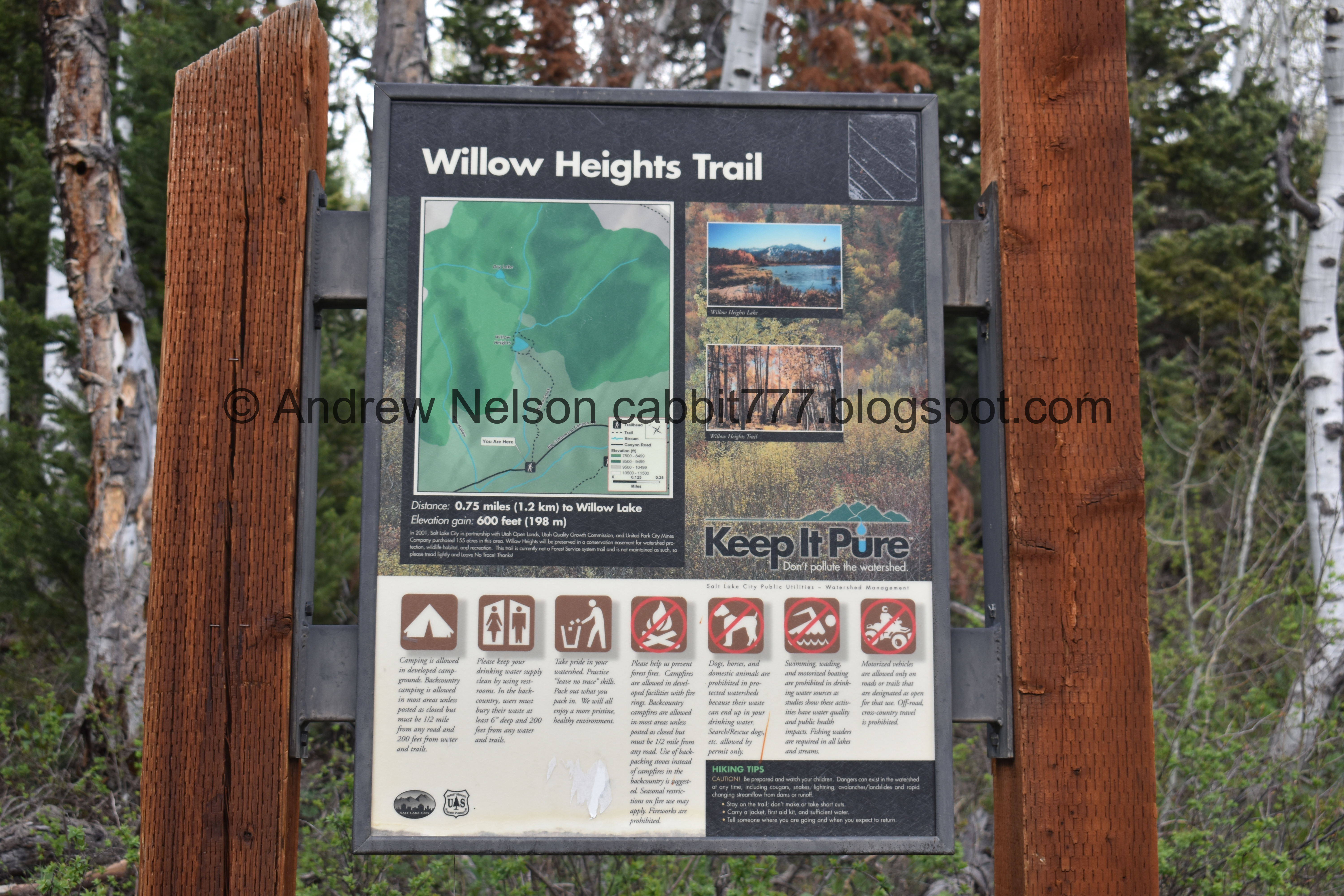
The trailhead sign. They still have not updated it to reflect the reroutes, and the closing of the original trail.

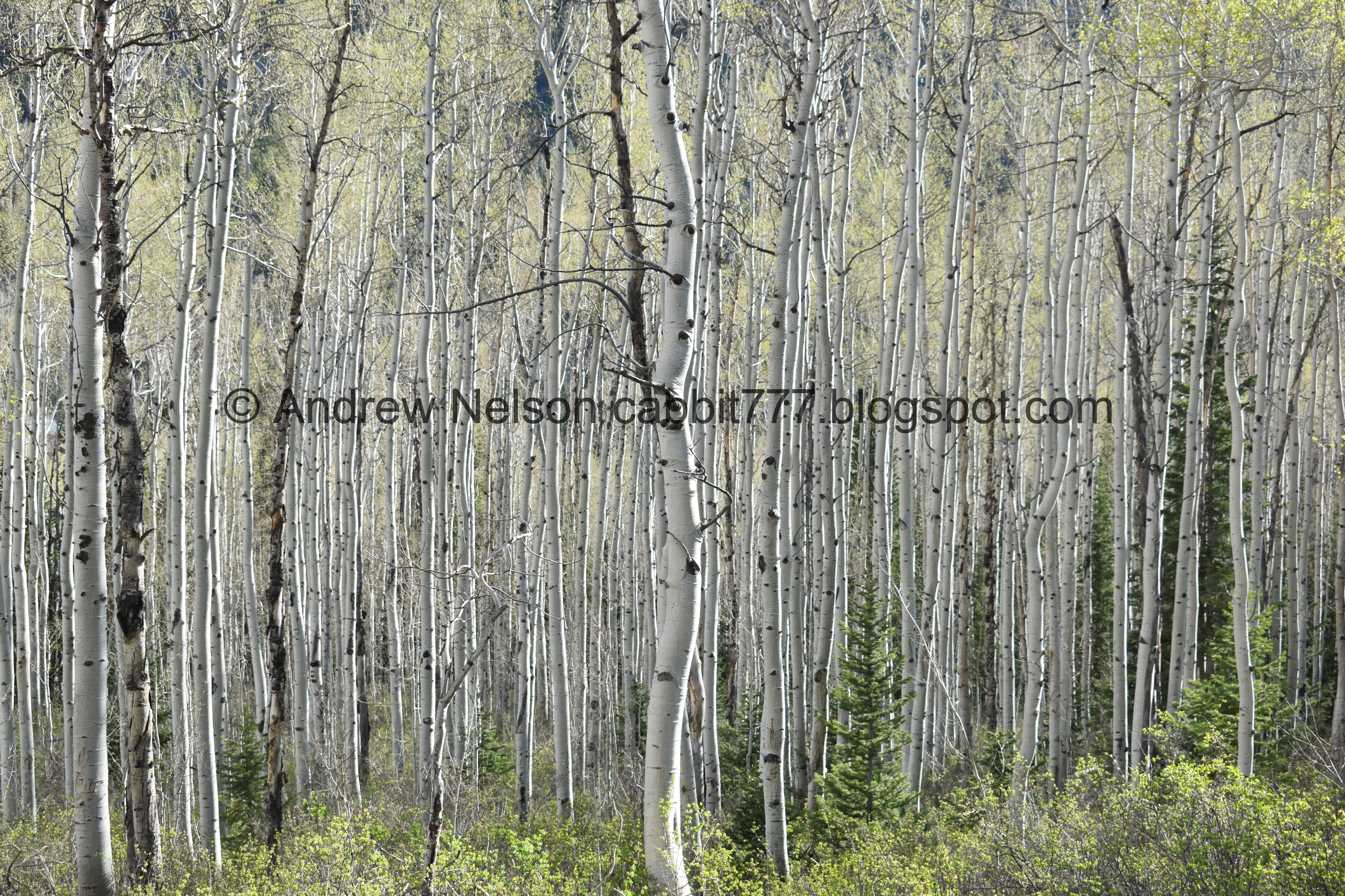
Nekkid aspen trees.

Some patches are starting to get leaves, and some aren’t. Interesting.

Well hello there cuteys. When you use the human trails, you might encounter humans.

The original trail. You can see they have covered it in sticks to discourage use.

Sorry guys! I promise I am not chasing you, just following the trail!

Some bluebells.

More lovely aspens.

The new trail split. The east fork (to the right) is slightly longer (at about a mile) but I think it is the more gentle, and much prettier route. However, there is a spot that makes me a little nervous. Considering we switched our plans today because of that I decided to just avoid it today.

The first creek crossing.

Looking across the canyon towards Silver Fork.

Where the trail joins an old dirt road. You want to go right. Left goes towards a neighborhood.
There were plans to develop the area and put in more houses and cabins. Luckily SLC saved it for us.

More aspens.

View down canyon.

Another patch of aspens getting their leaves.

Looking towards Brighton at the top of the canyon.

More nekkid aspens.

Another deer.

Another short reroute.

They really, REALLY do not want people using that old route.

Pretty flowers.

The reroute takes you closer to the creek for a bit.

More deer.


Oh, there’s quite a few of them up there.

They are so silly.

Rejoining the original trail.


More deer.

I think this was the moment they realized we were all walking the same direction and finally decided to stop and let us move past them haha.

Another patch of greening up aspens.

Nearing the top of the climb.

Aww, the cute little benches didn’t make it.

The little clearing. This means you are close.

Another super short reroute.

2nd creek crossing.

Looking up.

The big clearing. This means you are really close.

I love these cone shaped peaks up here.

The last push across the clearing.

Little pond. We could hear a lot of frogs, or toads in it. This generally dries up once it starts to be consistently warm.

4 way split. You can go either way, but I generally go left as it offers the best view of the lake. There is a lot of foliage to the right so you can’t see it as well from that way.

Another one of the cone shaped peaks.

First view of the lake.

3rd creek crossing. No bridge at this one, yet.

Willow.


Male deer.

He also appears to be a juvenile, based on the basic antlers.

The lake again.

I love the aspen reflections.
We often find moose up here at the lake, but no moosey friends today.
The lake again.
There is a nice little beach area here on the west side.
.jpg)
Panoramic.

A particularly loud group came up, so we decided to continue the loop around the lake.

One of the cone shaped peaks.

The back of the lake with the mountains on the other side of the canyon.

Again.

From further back.

Willows, aspens, and peaks above.

The back area is flooded this time of year too.

Not sure what these are, but they look super happy! I am guessing possibly corn lilies.

Entering the back wooded section.

The trail is a bit thinner back here, but still pretty clear.

The aspens are thick back here.

This creek crossing is a lot more dicey. There are springs coming up everywhere.

The creek.

The lake through the aspens.

Beautiful aspen forest.


Fallen trees from the great windstorm of September 2019. There actually seemed to be a few more possibly from some additional windstorms we have had since. So, note, not a good place to be on a particularly windy day.

Some of the fallen trees have new trails around them, some you just have to step over.

So many!

Snow! Honestly, I thought there would be a lot more snow up here than there was. I know we are experiencing a drought, but this is kind of crazy for this time of year.

5th creek crossing. This one is usually dry, I can’t remember a time I have seen water in it.

A couple of the fallen trees have been cut to allow easier access.

Pretty saddle.

Well, we did end up having to trudge through some snow today. Like I said, I am just surprised there wasn’t more of it. This wasn’t too bad, no post holing today.

The east side of the lake, as I said, lots of foliage in the way. There are a few little trails to get to the lake, but they are thin.

It looks like these aspens experienced some kind of event while they were young. Possible avalanche or whatnot.

4 way split again. Left leads down the east fork, middle the west fork, and right will take you around the lake again.
.jpg)
Panoramic of the big clearing and the mountains across the canyon.

We went down to the little pond

Reflections.
I briefly considered going down the east route, like I typically do, but decided to go down the way we came, so we crossed over to the west route.

Back into the woods.

Looking up again.

Upper bridge. Both bridges came with the trail reroute.

The small clearing.

Down to the trail reroute.

Quick view of the creek.

Nekkid aspens and a patch of greening up ones.

We were just saying that all the hikers (us included) must have scared off all the deer, and then we spotted one.


More greening up.

View across the canyon.

The wildflowers are definitely few and far between this high in elevation. Lower elevation is looking pretty good though.

Another part where the trail goes near to the creek, but you can’t really see it.


Aspens.

When coming down this way, keep an eye out for this little sign. If you miss it, the trail will spit you out in a neighborhood. It’s not the end of the world, and you can work your way back to your car, but it’s not as pretty and is a bit longer.

More aspens.

With some greening.

Bluebells.

The lower bridge.

Gnarly split tree.


Another green patch.

Before you know it, you are back down to the road.

More pretty flowers.

View up canyon.

We stopped by Mill D real quick to see if the moose was still there, no luck. But here is the neat beaver dam.

Looking up Mill D South.

Big Cottonwood Creek.

We made a quick stop to Moss Ledge Waterfall as a quick add-on hike.

The mouth of the canyon (PSP).
I really love this trail! So we do tend to do it often. It has been fun watching the reroutes take shape over the last few years too. It was not terribly busy today either. I also enjoyed the wildlife today. Plus it was amazing to be up in the mountains again! 10 out of 10 squirrels today.
As for difficulty, there is a bit of a climb, but it’s not too terrible. DR3.
Dogs are not allowed in Big Cottonwood Canyon due to watershed. Be sure to leave Fido home for this one.

No comments:
Post a Comment