.jpg)
Yellow Fork Canyon is a pretty canyon in Herriman. It features a mess of trails through some lovely mixed woods, a small creek, and a good chance of seeing some wildlife. I always struggle this time of year to find a trail to do and tend to default on some of these easier trails in our designated open spaces. Often there is no WOW destination, but I enjoy the adventure.

Quick Details:
Length: All the way to the upper picnic area is about 2 miles. We only made it up about 1.5, or 3 out and back.
Trail Type: Out and back, longer loop option.
Difficulty: DR3.
Elevation Gain: 446
Restroom: Yes, pit toilets.
Dogs? Yes, leashed.
Other Info:
To Get Here:
From i15 take exit 289 for Bangerter Highway. Go about 5 miles and turn left on 13400 S. Go about 3 miles and turn left on 6400 W,/Rose Canyon Rd. .6 miles later turn right to stay on Rose Canyon Rd. 1.4 miles later turn left to stay on Rose Canyon Rd. About 2 miles later will be the trailhead parking.
You can cross the bridge and head right, or go a bit to the north and hike up the road.
The Trail:

New trailhead kiosk.

Well neat. That explains the weird structures we saw last time, they are Beaver Dam Analogs. And they may attract beaver to the area, but either way will achieve what beaver dams do and restore the riparian area. Neat.

The original trailhead kiosk.

I guess you used to be able to drive up these canyons but not anymore. I could not find when that happened. Appears to have been long before google maps mapped everything.

For some reason, previous trips I took the trail up, and I always mentioned how we should do the road up LOL. They both lead to the same location, so today we went up the dirt road.

Little bit of color hanging on.

View up.

Sunlight! It’s particularly frigid today. I totally choose the wrong trail to get some sun.

The creek with two of the analog beaver dams.

Another one up stream.
I went back and forth about going up the canyon to the Left towards Big Rock or continuing strait along the main road. On the one hand, left would offer more sunlight, but then we’d be hiking into the sun. We opted to stay on the road.


Here at the split, which is about a half mile up you come to the first picnic area.


Back in the shadow of the mountain we found the creek flowing under a layer of ice. I also find it interesting that the creek goes from being a a somewhat deep gully to just flowing over the land here. Must be a definitely different type of soil.

Another beaver dam analog.

There was a bit more snow than I was anticipating. I didn’t think we were high enough.

There were also a lot of fallen trees.

Before long it was full on hiking through the snow. Oi. Luckily it was neither deep, nor slippery.

The creek, back in a little gully. Plus another beaver dam analog.

More fallen trees.

At about a mile we come to this creek crossing, with a single picnic table.


The creek again.

Little bit more color.

The creek working its way down a little gulley.

Spooky naked forest.


Pretty naked forest.

I’m pretty sure these are birch trees.
Then we come to a big clearing.

More birch.

More beaver dam analogs. About here I happened to notice that they all seemed to be demarcated with these pink flags.

Pretty canyon.

More snow.

The creek with more beaver dam analogs.

Another spot of color.

Back to a frozen creek.

A large juniper tree.

At about 1.5 miles we made it to another picnic area, where the road crosses the creek again. I mentioned it was cold right? I had planned on going to the upper picnic area at just another half mile or so but, well, I was just freezing, and decided this would be our destination today. So we took a break before heading back down.

Tiny patch of red.

Little bit of orange left, though most of it has dropped.

Forest.

Fun clouds.

The creek again.

More birch trees.

Side canyon. It looks like the Nicoletti trail heads up there. I might look into that one.

More birch.

Back to the big clearing.

Well hello cuties. I see deer up here pretty much every time we come.

With some fall color.

They aren’t sure what to do about us.
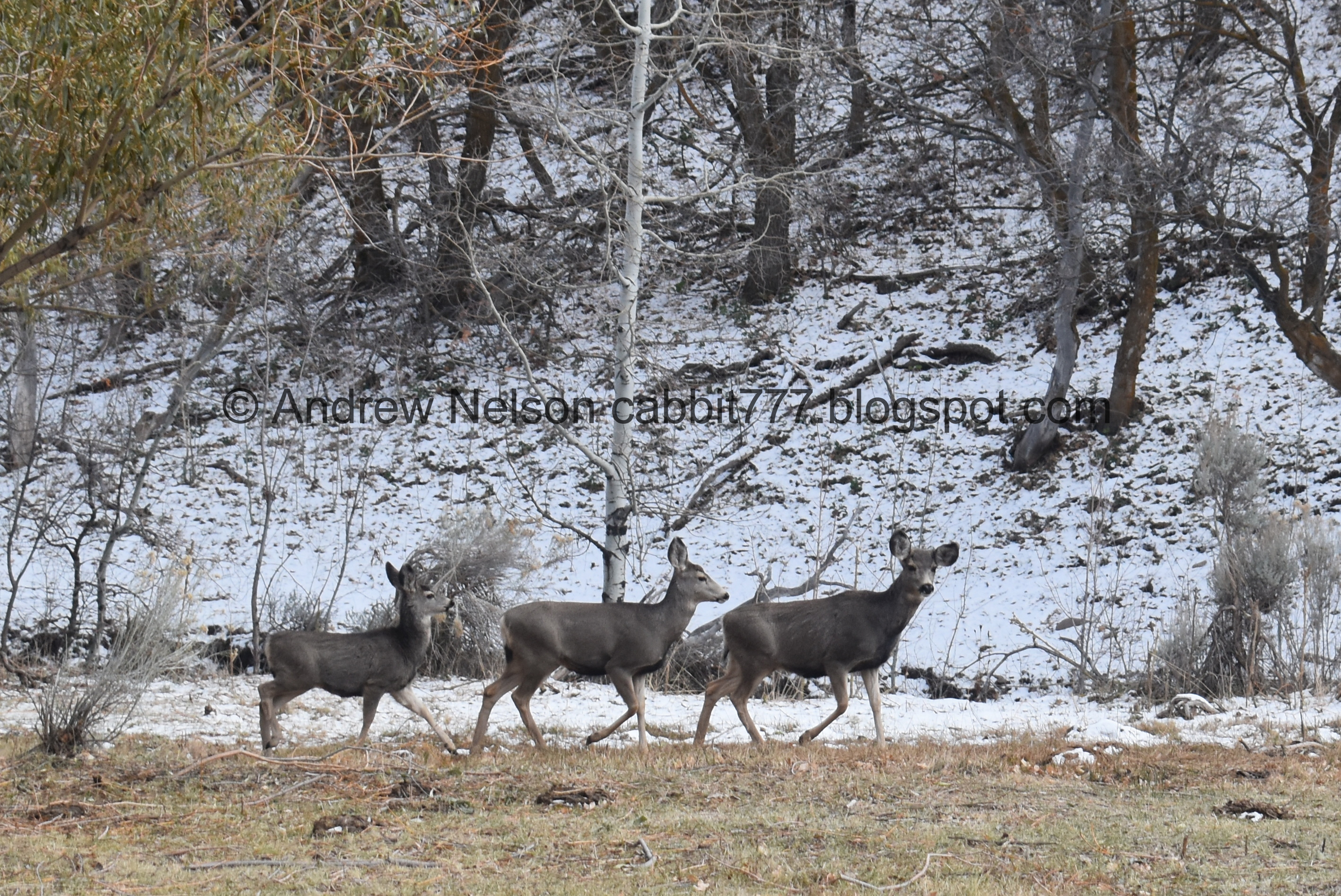
First they started heading up, while we were heading down. Ultimately that would have been the better option for them to get away from us, but deer are skittish things.

Getting a mild Charlies Angels pose vibe going here.
They decided to bolt the other direction.

The hillside.

The deer decided to head downhill, and then cross over the trail and up the other hill. Sigh. Sorry guys.

Hello again! I snapped a quick shot then kept moving so as not the agitate them any more.

Almost naked trees with all their dressing on the floor.

The hillside again.

Forest lined road.

Some leaves hanging on.

Down to the single picnic sight with the creek crossing.

Frozen creek.

For a solid moment I thought we might have come across a coyote or something. It was a dog LOL. I forgot for a moment that people are jerks and don’t always follow the leash rules.

More forest.

Some color.

The part where the creek isn’t down in a gully.

Crossing over it.

Back down to the lower picnic area.

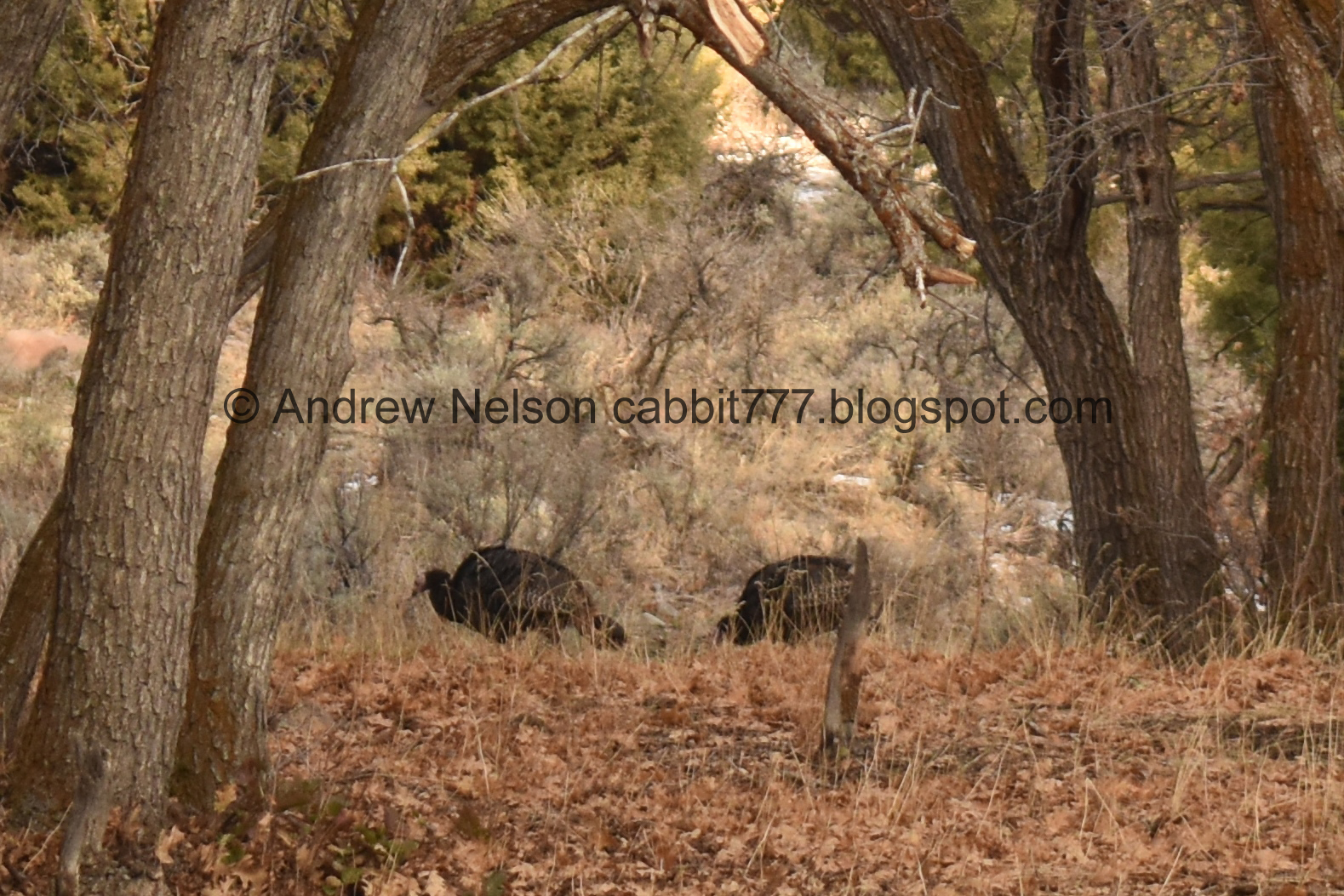
I noticed some movement, that I thought was deer at first but nope, turkeys!
Digital crop.

Another one.

Make that a pair.

Another one.

2 more. They are fairly spread out but ultimately we counted 7.

They are not as skittish as I imagined they would be.

Another one.

One of the previous pairs.

The picnic area again.

The creek again.

Eventually I thought about my telephoto lens and went back to the turkeys.

And then the battery in my camera promptly died. My fault, I didn’t pay attention to the meter and didn’t charge it last night.
The rest of the photos will be from my phone.

Looking down canyon.

More color.

Neat striped hill.

Nearing the gate.

Random pillar, which is new. I wonder if it is art, or something else. We didn’t get much closer though.

Another flock of turkeys.

Again.

Looking down canyon again.

The turkeys heading up the canyon.

The zoom on my phone isn’t too shabby.

Must be something interesting there.


It’s fun watching them do their thing.
They eventually started working their way up the canyon and I decided I had enjoyed watching them long enough so we decided to head back home.

Step Mountain (PSP).
Well, there wasn't much to the trail today other than the fun wildlife sightings. We don’t spot wild turkeys very often, so 2 flocks in one day was a fun treat. It also wasn’t too busy. However it was bitter cold today so we didn’t go too far. 8 out of 10 squirrels.
As for difficulty, its a pretty gentle climb. DR3.
Dogs are allowed but should remain leashed at all times.

No comments:
Post a Comment