.jpg)
Yellow Fork Canyon is a pretty canyon in Herriman. It features a creek, and some pretty forest. It is a great easy hike in a canyon. Almost every time we come here we see deer, and sometimes other interesting wildlife. This is another trail we do pretty often, but it is a good easy option. However, we totally forgot how tough it is to hike through the snow! So that was a good reminder of why we generally stay lower elevation this time of year.

Quick Details:
Length: We did about 3 miles out and back, but it does keep going and offers some longer options.
Trail Type: And and back, balloon and loop options.
Difficulty: DR3. It is a pretty gradual climb.
Elevation Gain: We did about 440 feet.
Restroom: There is a vault toilet at the trailhead..
Dogs? Yes, leashed.
Other Info:
To Get Here:
From i15 take exit 289 for Bangerter Highway. Go about 5 miles and turn left on 13400 S. Go about 3 miles and turn left on 6400 W,/Rose Canyon Rd. .6 miles later turn right to stay on Rose Canyon Rd. 1.4 miles later turn left to stay on Rose Canyon Rd. About 2 miles later will be the trailhead parking.
If you are starting from Bangerter and are north, Start from 13400 S. But turn right, then follow the rest of the directions above.
From there, cross the bridge over the creek and take the right fork. Or you can hike up the dirt road on the right (north).

The Kennecott Copper Mine (Passenger Seat Photography (PSP)).

As far as canyon roads go, this isn’t bad at all (PSP). It’s a little windy, but no drop offs or anything.

Wild turkey (PSP).

Again (PSP).

Oh! It’s a big group (PSP). Luckily there was nobody behind us so we could take our time enjoying our random wildlife sighting.

Some are crossing the road from the other side (PSP). Too bad the joke is abut a chicken crossing the road rather than a turkey.

This one came out well (PSP).

This one too (PSP). Run turkey run!

Crossing (PSP).

Into the snow (PSP).

This one took a little tumble (PSP). I wish I was filming.

Off they go (PSP).

Turkey butts (PSP)!


Continuing up the canyon (PSP).
The Trail:

Step Mountain. I still want to go up there someday.

The fairly new trailhead kiosk.

Closer view of the map.

Restoring Wildlife Habitat. This talks about the beaver dam analogs that you will see along the way.
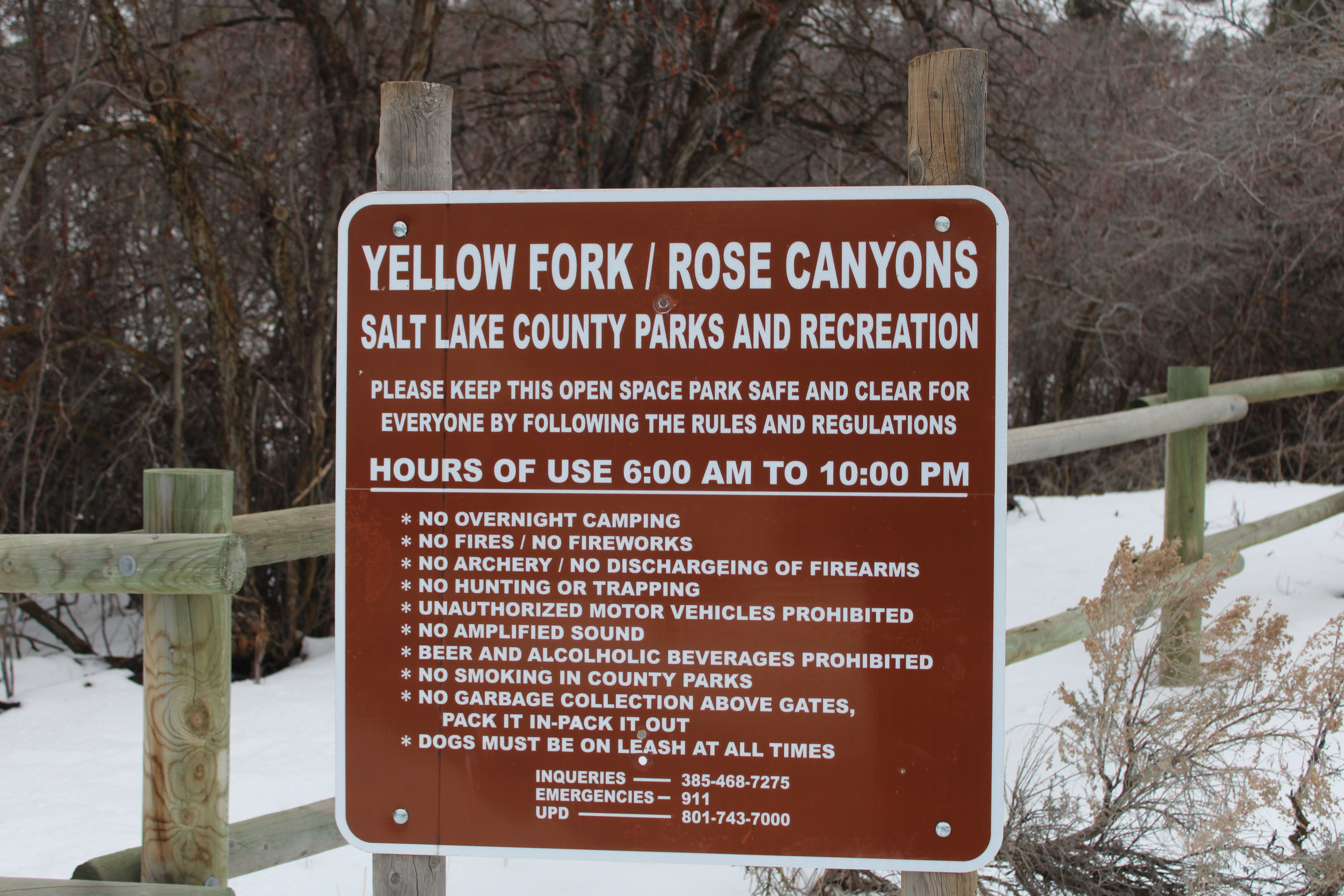
Area rules.

We decided to hike up the old Yellow Fork Road today. The trail is generally fine too, but we figured the road might be more packed down. The trail is to the south of here, on the other side of the creek. Use the foot bridge over the creek to access it.
I don’t know when the old road was closed to motorized vehicles, but from what I can tell this gate came up somewhere between 2007 and 2009 using google earth.
Sometime between 2013 and 2015 they put in the gate across Rose Fork Canyon and expanded the parking lot.

Continuing up.

Scrub oak.

A rather large juniper.

There were quite a few slushy parts near the beginning, but it got a bit less slushy a little higher up.

The creek in its deeper gully.

More scrub oak.

Looking up canyon.

The other side of the canyon.

Big snowman, with people for size. This was 1 of only 2 groups we passed today.

Closer to the random snowman.

The creek below again.

Beaver dam analog. As the sign states they put these in to simulate normal beaver dams. It is hoped that the analog dams will restore the creek enough that beavers move back into the area and maintain the dams themselves. However, whether beaver return or not, the analog dams do restore the local riparian area.

Another one.

The creek.

Where the canyon splits. Left leads towards Big Rock, right is the main fork.

Big Rock Fork.

Main fork.
.jpg)
Panoramic.

Just above the trail split is the first picnic area, at about a half mile up. They have added some fencing in here.

Oh they are revegetating native plants.

This seems weird and unnecessary. Why did they make a longer V instead of just a straight line here?

Raven.

Here the road crosses the creek, and the creeks bed is a lot less deep. I’m guessing whatever the underlying soil type changed.

Continuing up. The footpath trail is next to the old road through here.

Another beaver dam analog.
The stream is mostly under a layer of snow through here.

Oof. I totally forgot how much more work it is to trudge through the snow.

More oaks.

Beaver dam analog.
If it seems like there are a lot of them, there are, and it’s on purpose. The more of them, the more likely they will achieve their goal of repairing the riparian zone.

It has been a minute since we had a good snowy hike. It’s tougher, but it quite pretty in it’s own way.

Broken trees.

Another little picnic area.

Where the road crosses the creek again. The trail stays on this side of it here.

Downstream.

Upstream.

Fallen leaves working their way down in the snow.

Lots of oaks through here.

The creek again.


More forest.

The creek.

Birch trees.


Then these bright orange willows certainly stand out.

At about a mile up there is this big clearing.

More birch trees.

I’m not sure what this guy is, but it has the same weird red coloring as the oaks have. I thought it might be the fungus called rust before, but honestly I have no idea what it is.

The creek.

Up canyon.

Continuing up.

Nicoletti Trail. From what I can tell this connects up to the Bonneville Shoreline Trail (BST) above.

It goes up this little side gully. I might check that out someday.

Continuing up.

Looks like somebody skied down here.


Hills above.

The creek.

Continuing up.

Juniper.

Juniper berries.

Pushing through the snow.

Twigs melting down into the snow.

Continuing along.


Turkey Hollow.

Or, according to this sign the Butter Knife/BST? Not sure if there is a trail split or if they are renaming it.

This little picnic area is just short of 1.5 miles up.

Right after the picnic area the road crosses the creek again, and if I remember correctly, the foot trail does too. So both paths are now on the opposite sides of the creek.

Downstream.
My pedometer app hadn’t dinged 1.5 miles just yet, so we pushed on a little further. I think the road is just a smidge shorter than the trail.

The view down canyon.

Forest.

Old 1 1/2 mile marker.

More forest.

Before long my pedometer dinged 1.5 miles so we called it. About another half mile up is another picnic area that is the furthest we have gone up this canyon. But, we had enough trudging through the snow today, so we decided to turn back.

Crossing back over the creek.

The little picnic area.
The ridge.

Continuing down.

The creek.


Lots of junipers.

The creek.

The ridge.

Continuing down.

The old road and the creek.

Neat tree again.

Back to the big clearing with the bright willow trees.

Closer.

Much closer.

Looking back up.

Continuing down.

Oaks.

Forest.

Looking up.

More forest.

Looking up again.

I love me a good thick forest.

Looking up again.

Crossing over the creek again.

More forest.


Continuing down.

Mountains.

It looks like something punched through to the creek.

The revegetation area and the creek crossing again.

The lower picnic area. Just a half mile to go.

The Big Rock Fork again.

The creek again.
.jpg)
Looking back towards both forks again.

The creek.

View down again.

The big snowman again.

The ridge.

Continuing down.

Cliffs.

The creek.

Super muddy spot. It was only about 10 feet or so.

The ridge with Rose Canyon on the other side of it.

Back down to the gate.

The fancy directional marker. Between the canyons at the trailhead.

Step Mountain.

Where Yellow Fork Creek and Rose Creek Join. It continues downstream as Rose Creek. You will use that bridge to access the Yellow Fork foot path.

All the mud being pulled out of the lower parking lot from exiting cars (PSP). Yuck.

We didn’t see any deer on the hike like we usually do, probably because they are all hanging out below the trailhead (PSP).

Interesting art we found along Herriman Main Street (PSP). I couldn’t find any information on it so we’re just going with art.
I enjoy this trail. Like I said it is a nice easy stroll up a nice canyon. It also isn’t very busy. which is always nice. There are a lot of trails in the area to explore, however I usually decide on this trail when I just want something easy that I am familiar with haha. But, maybe we’ll explore some more of them eventually. I did forget how much wore work it is to trudge through the snow. Oof. There is a reason I generally stick to lower elevation in the winter. 8 out of 10 squirrels today.
As for difficulty, it is a pretty mild climb. DR3.
Dogs are allowed but should be leashed.

No comments:
Post a Comment