.jpg)
I was wanting to head up higher in elevation today, however after checking the temperatures (48 up there yikes!) we decided that we’ll do another lower adventure today instead.

Quick Details:
Length: The guide I used said it was 4.1 miles out and back. we did 4.66 miles out and back and did not quite make it to the end.
Trail Type: Out and back.
Difficulty: DR6. This trail is all uphill and never lets up. Near the top the trail is extremely overgrown and sometimes hard to follow, then there is a steep extremely muddy section.
Elevation Gain: The guide I used said 1965 ft. we did 1686.
Restroom: No. The closest would probably be the smiths down the canyon rd.
Dogs? Yes, Leashed.
To Get Here:
Head up Ogden Canyon. About 1.3 miles from the mouth of the canyon there will be a small dirt turn off with a decent size parking lot.

The mouth of Ogden Canyon (PSP).
The Trail:

You will pass by the Historic Ogden Canyon Kiln on the way up.

Information sign.
Though, not a whole lot of trail info here.

The Indian Trail info sign. This is the main trail here, Coldwater Canyon Splits off just below the 2nd bridge.
As I understand it, this trail was used by early Native Americans as a way to get from the top of the canyon to the bottom when the Ogden River was flowing too high to get through the narrows near the mouth of Ogden Canyon.

Smoky Bear says fire danger is low today. I think that might be unusual for this time of year.

Neat peak above.

I struggled a bit through this first segment. I am not a fan of thin trails on steep slopes. I almost called it quits here and a couple other parts along this first segment, but, I took it slow, and made sure to take a few breaks to catch my breath and I made it through this first awful section.
A good thing about this trail is that the worst part of it is at the beginning here. So you don't aste a mile or so hiking to discover a nasty section that you cant get by. So, if you can get through these first switchbacks, you will be fine for the rest of the way.

Okay, they have shored up this section. Maybe it wont be so bad.

Beautiful forest.


This trail is starting to remind me of the Columbia River Gorge in Oregon. So green and pretty, and steeper than I would like!

More switchbacks.

Oi. It is really pretty though here, but it took a lot of courage to get though here. I have found that if I take it slower, and stop to catch my breath more often, I can manage a little better. Doesn't always work, but it did today.

Ah, this is a little better.
So, if you struggle on steep slopes like I do, that was the absolute worst of it. There is a little bit more, but not nearly as bad as the previous segment.

Random memorial. This one is not marked at all so I don’t know who it is for, or why.

The trail is kind of nice though here.

Another section of thin trail along a steep slope. This was not as bad as the previous switchbacks though.

Eventually the trails is okay again but now we are heading down hill which means we will have to climb this on the way back. It was fairly short so not a big deal.

Little foot bridge over a small spring.

The little spring.

This is really bizarre. It looks like a hot spring like we would find in Yellowstone, but it is cold. Most cold springs around here that I am familiar with anyway, do not have a deep pool looking like a morning glory like this. Really bizarre but neat.

Little camp ground here.

Pretty forest.

The kiosk mentioned an old civilian conservation corps camp somewhere around here. I wonder if this is leftover from that.

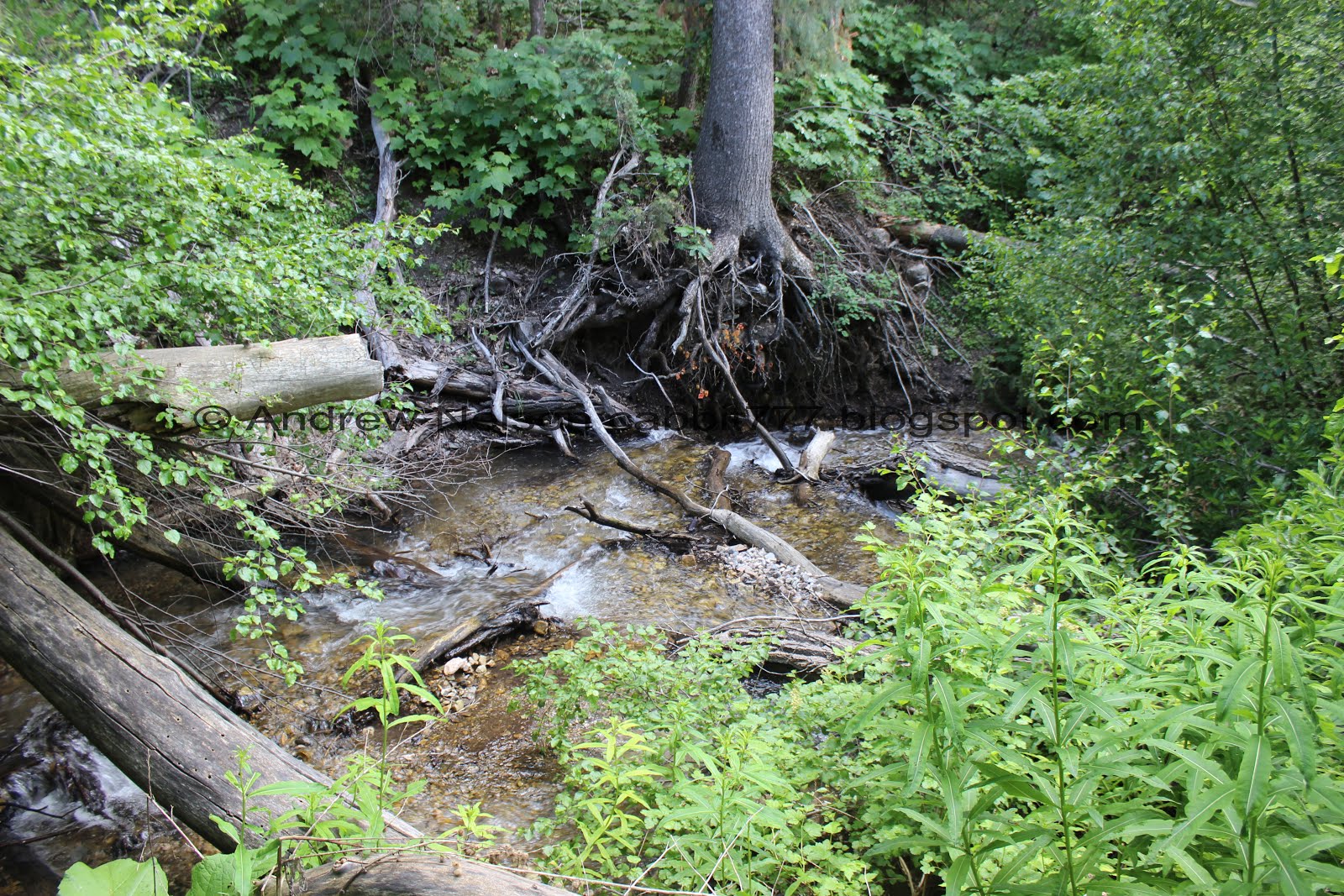
The first bridge.

Coldwater Creek.

Another little spring. This is more like the springs I am used to seeing around here.

The creek again.

The forest again.


Another spring.

There are a million sunflower looking varieties in Utah so they are hard to identify, but I am leaning towards heartleaf arnica.

Thimbleberry flowers. These are all over the place on this trail!

Mossy trees.

The forest is just incredible.
The creek again.

Some kind of overflow pipe.

Creek and forest.


These look just like taper-tip onions except they are more white.

Bluebells.

Lovely trail.

Remember to look up occasionally.

The trail again.

The creek again.

The 2nd bridge.
So, if Coldwater Canyon is what you are after, if you hit this bridge, you went too far. But only just a smidge.
We just passed a side trail, and I remember the split off for Coldwater Canyon is near this bridge.

The creek again.
Well, we don’t see another split near here so I decided to consult the map again. Oh, the split we want is just before the bridge okay.

Short little backtrack. The trail looks a bit thinner, which is why we overlooked it. But note, you can see the bridge from it, it is really just before the 2nd bridge.

The trail is quite a bit thinner than the main trail, but it is still easy enough to follow, so far.

Gnarly looking burl.

Every once in a while the trees open up and allow you to see the mountains above.

A little side stream. I was worried this was going to be the trail now.

But just a couple feet up there is a trail on the other side.

The little stream through the woods.

Another heartleaf arnica (I think).


So green and pretty up here.

T junction. We guessed that right was just an overlook for the stream (confirmed on the way down) so we went left and determined that was the correct choice.


Penstemon.

Large trees.

Dogbane.

Cliffs above.

Wild snapdragon.

Wild wild forest.

Looking up again.

Some of the trees up here are absolutely huge.

Interesting tree pairing.

More pretty forest.

This section of the trail was my favorite, and looking back would probably recommend as the destination.

The creek flows lazily next to these mossy cliffs.

It is super pretty here.

Pretty side stream joining the main creek.

The trail crosses the main creek here. It was easy enough to step across though.

Looking back at the creek below the cliffs.

Pretty trees and cliffs.

Foliage is starting to get a bit higher.

Pretty flowering tree.

Starting to get more wild.

Gnarly tree.

Another nice campsite.


More pretty forest.

Random pipe.
I am not 100% sure, but I think this might be the location of the old sawmill we were after. I took a couple more pictures on the way down. But, all I noticed was the pipe so we kept going…. I think I would have preferred if we stopped here.

Tons and tons of thimbleberries.


The woods are so thick up here! It is pretty neat.

The trail is getting a little thinner.

There were a couple spots where trees have fallen across the trail but they all detour trails around them.


Crazy thick forest.

Looking up again.


First columbines of the year. These are one of my favorite wildflowers. Particularly the much more rare blue and purple ones. White is what I usually find around Utah.

This flower hasn’t quite bloomed yet.

Starting to get quite a bit overgrown.

Thimbleberries as far as you can see. Also notice they are starting to obscure the trail quite a bit.

They are kind of pretty though.

An opening in the trees allows us to see the white cliffs above.

Neat rock formations.

Closer look at the white cliffs.


The trail is getting a little bit hard to keep track of. Near the end I started to wonder if we had lost it and were just following a game trail.

Because the trail wasn’t tough enough already, now there is mud.

Not just mud, but thick sucking mud that threatens to take your shoes. There is either a spring, or a spillover from the creek running down here.

We dealt with the mud for 30 feet or so, slipping and sliding, while it just continued to get more steep. I don’t know if it is normally this muddy, or just with the wet year we had but yea.
Not that I could see very far ahead with the thick foliage, but it just didn’t appear to end anytime soon. We went over 2 miles at this point so we decided to call it quits. I hate to give up knowing we had to be near the end of it, but it wasn’t enjoyable anymore at this point. So, back on down we went.

The awful mud again.

Looking down canyon-ish.

Overgrown trail.

The cliffs again.

I’m not 100% sure but this looked like petrified wood to me.


Thimbleberries for days.


Back into the thick woods.

Looking up again.

I’m leaning towards this being a chickweed of some sort.


The thin trail.

I noticed this section with quite a few fallen trees. It was windy enough that the trees were scraping against each other quite a bit today so that was a little worrisome.

Knothole.

Old metal parts.

Some parts in a fire ring.

There is a square depression here with some pipes and scraps of metal. I am still not sure, but I am fairly sure this is the old sawmill site.

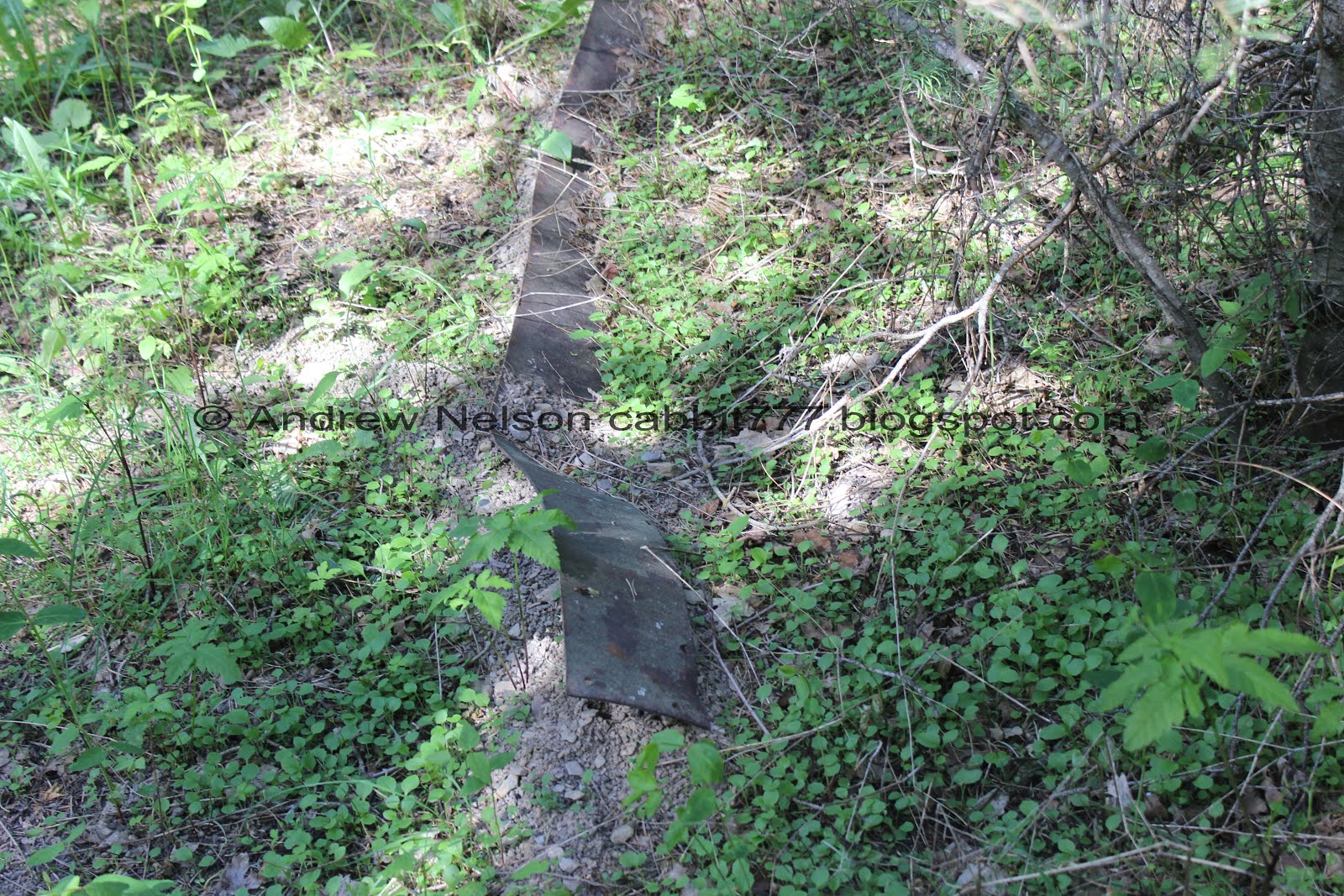
More parts.
I don’t know how I missed this on the way up. I noticed a pipe and the depression, but missed all this other stuff. Meh, not much too it, but I am happy we found it.

Heading back down the trail.

There are some huge trees on this trail.

Quite a few spots along the trail made me miss Oregon.

Scree field.

Neat cliff.

Tree on the trail with the new detour.

Cliffs.

Back to my favorite part of the trail. Coldwater Creek next to the cliffs.

Little side creek flowing into Coldwater Creek.

The creek again.

Side creek again.

The creek.

Mossy cliffs.

Little log waterfall.

Beautiful woods.

Tree pairings.

Cliffs above. These look very similar to not too far from here Wheeler Creek.

Another gnarly burl.

Looking down Coldwater Canyon and across Ogden Canyon.

We took a side trail down to view the creek again.

The side trail continues across the creek. I don’t know for sure, but think it might connect with the main trail. This was a the T junction we chose left at on the way up.

Said T junction looking at as if coming up. Left continues up the canyon, right goes to the creek and down goes back to the trailhead.

Back down to the little side stream.

Where the trail picks up again just a couple feet below.

Thin trail.

The 2nd bridge along the main trail means we should be just about back down to it.

Back to the main trail.

The creek below.

Again.

I think this is a mourning cloak butterfly. He appears to have gotten a little wet and is probably trying to dry out.
Random fun fact: at 11-12 months, they have one of the longest lifespans of butterflies.

The creek split into 3.

Little cascade.

Going around the bend.

Where a spring joins the creek.

The lower bridge. Almost done!

Back to the first odd spring. I wanted to take a couple more photos of it as the lighting was better, but there was a kid trying to figure out how deep it went and I didn’t want to be a jerk and ruin his exploring.


Now we have a short climb back up to the ridge. Oi. Actually it's not too bad.

Looking up.


The steep side canyon looks so much like Oregon.

The other side of Ogden Canyon.

Gnarly roots.

The forest and approaching the switchbacks.

Looking down at the steep switchbacks. It’s pretty through here but oh boy.

I do a little bit better on the way down than I do in the way up so I was able to get a couple more pictures of the switchbacks.

Looking down again.

I know I have said it a few times but this part really does remind me of Oregon, specifically the Multnomah Falls area.

So green and pretty.

Please don’t cut trails hahaha, trust me, definitely not going to happen at least not from me.

Little slide area.


Looking across Ogden Canyon.

Neat peak above.

Back down to the Historic Ogden Canyon Kiln and solid flat ground again! Woohoo!

The parking lot and the looking down Ogden Canyon.

Looking up Ogden Canyon (PSP).
This trail was super pretty right now. I really enjoyed the green green forest, the creek, and the wildflowers. I also liked that after we split off from the main trail we only ran into 1 other couple so it was quiet. However this trail just never really let up and was just a long steady climb. And the switchbacks at the beginning were intense. However, on the plus side, they are right at the beginning so if you make it past that, that is the worst of it. And then of course there was that horrible steep muddy section at the end. Meh, 7 out of 10 squirrels.
As for difficulty, like I said this is a non-stop climb! Plus with the overgrown sections and the muddy part I think I might need to bump this up to a DR6.
Dogs are allowed, however must remain on leash.

No comments:
Post a Comment