The Temple Quarry Trail at the mouth of Little Cottonwood Canyon in Sandy is a lovely, short trail system that gives a bunch of history of the area. We came to do the Little Cottonwood Trail, which is connected, but found we were not wearing the best shoes so we only made it to the first bridge, so we decided to do the Quarry Trail again since it has been a while. We ended up only doing the paved loop and spur.
Quick Details:
Length: About half of a mile, with additional options on unpaved parts.
Trail Type: Loop with a spur. or Loop with several spurs. Some day it will be a double loop.
Difficulty: DR2. Paved, easy.
Elevation Gain: Maybe 20 feet?
Restroom: Yes. Not sure if it is open in winter though.
Dogs? No. Little Cottonwood Canyon is watershed.
Other Info: Make sure you do the spur in the middle!
To Get Here:
Take i15 to the 90th south exit and head east. keep going up past where 90th becomes 94th. Just a smidge past Wasatch, 94th will connect to Little Cottonwood Canyon Rd. The trailhead is on the right, just before the stop sign for that.
The Trail:
When at the mouth of Little Cottonwood Canyon in winter, be sure to keep your eyes open for mountain goats. If it is snowy, they are definitely harder to spot, but this guy decided to stand in front of a tree for me.
I still have no idea how the heck I spotted him though. Can you find him in this picture?
The cliffs.
Mountain goats again.
A little closer.
Icy run off.
Lots of run off coming down on the Little Cottonwood Trail.
Cliffs.
We then went about mile up the Little Cottonwood Trail before determining we didn’t have the right shoes to trudge through the, much more snow than I anticipated. Nothing new or exciting so I will skip to when we came back to the Quarry Trail.
This always amuses me. The darker colored leaves absorb more heat and start melting the snow underneath them so they start sinking in.
We entered the far east end of the Temple Quarry Trail.
How rocks affect us humans, and wildlife. How they shape where we put towns, how the highway going up the canyon, different jobs people sought.
Fallen tree. Probably due to the great wind storm of September 2020.
Cliffs.
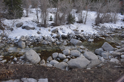
Little Cottonwood Creek.
More cliffs. Not seeing any mountain goats just yet.
How water shaped the canyon. A glacier receded down the canyon creating the U shape.
One of those random stick structures. I swear I see one of these on just about every trail we do.
There was an old dam for a hydroelectric power plant. The creek is (normally) dry here due to a newer power plant further upstream.
What remains of the old dam.
The creek again.
Cliffs again.
Heading down the trail.
The scrub oaks, still hanging on to their leaves.
Rocky Mountain Goats are able to maneuver on these cliffs due to the abrasive pads they have on their hooves that stick to rocks.
They seek mineral licks leaching from cracks in the rock. As the snow melts they will move higher up seeking grasses and flowers to east.
As I understand it, the goats can be seen here at the mouth of the canyon from November to April.
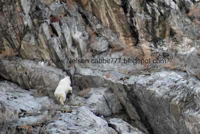
Oddly enough, right at the mountain goat sign, I finally found some mountain goats! Can you see them?
Little bit closer.
You know, it is impossible to tell with wild animals, bit I am pretty sure these are the same two we saw on the way in.
You can see the second one a little better here.
I swear he can see me, because it felt like he was just staring me down.
Oh good, he looked away haha.
I love watching them scramble around the rocks.
Here to show how high up they are.
Cliffs again.
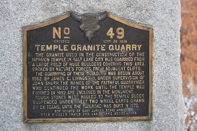
In 1861 they started quarrying the granite here to build the Salt Lake Temple and continued for 25 years! Moving the granite from the canyon to downtown SLC was quite the challenge. Some of the larger stones, weighing close to 2 tons, they had to place a reinforced wagons, then dug trenches under the wheels. Many wagons broke down with all that weight and having to travel 20 miles to the temple.
In the late 1860’s they dug a canal to try to float the stones to the temple (I learned a bit about that on the Wasatch Hollow Preserve trail). That idea didn’t pan out and it was abandoned when the railroad came to Utah in 1871.
By the late 18880’s quarrying stopped. Stones from the quarry were also used to build the State Capitol and the This Is The Place Monument.
By the way this is at the end of the little spur trail below the middle entrance (that has stairs) and it has the best examples of the quarrying here. so, make sure you do it!
Some smaller quarried stones.
Little closer. You can see the drill marks.
Unfortunately, this sign is too weathered to read what it is trying to convey. Actually, all of the signs are decaying in the same way, this one just happens to be the worst one. I would love to see them replaced one day.
Little amphitheater
Oof. Quarry workers worked in pairs. One held the drill bit, and the other slammed a sledgehammer into it (as the signs says, hope they don’t miss!). Then the bit was turned and another slam with the sledgehammer.
Every blow would send a shock wave through the rock, eventually with a sharp CRACK the rock would split.
You can see evidence of the drill marks in the stones around you here, as well as in several nearby areas such as The Granite Trail to Bell Canyon, The trail above here on the Little Cottonwood Trail. And even Ferguson Canyon.
It sure didn’t take much.
Well, sometimes. In some of the links I provided above you can see several examples where they tried very hard to split a stone, and it never came to fruition.
If a rock could tell you where it began, where it had been, and how it ended up here. Also talks of the different names of the granite found here.
Then, something else caught our eyes. More mountain goats.
Zooming out you can see there are 4 of them here. One of them is just separated a bit.
Look at them! How are they just chilling on the cliffs like that! (well, aside from what we learned earlier about their hooves). Landis spotted this group completely unexpectedly.
The separated guy.
Back to the other 3.
All 4 of them. You can really see the precarious position the guy at the top is in.
The lower 3 again.
Little closer to 2 of them.
Well, I managed to peel myself away from the goats to finish the rest of the trail.
The old town of Granite was originally here.
Okay, I didn’t completely peel myself away from the goats haha. Look at this crazy climber!
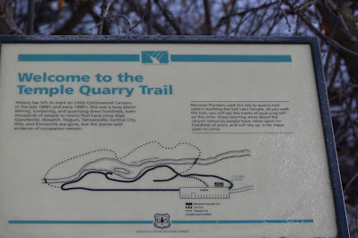
Another sign that explains the area.
This map says the completed trail is 3/10ths of a mile. Maybe I wandered a bit back and forth more than I thought I did haha. I am impatiently awaiting for them to complete the proposed trail.
It also mentions several towns there were nearby that no longer exist: Graniteville, Wasatch, Hogum, Tannersville, Central City, Alta (pretty sure Alta is still a town) and Emmaville. I have never heard of some of these.
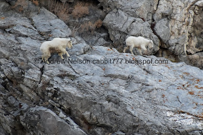
Both the males and the females sport the little beard and the horns. As far as I can tell the only way to sex them is that the males are slightly larger. So, I am unsure if I am seeing a couple, or mother and kid. However, the way the larger one seems to fuss over the smaller one, I am leaning towards the latter.
Such majestic creatures.
This is 1) the lowest down I have ever seen them and 2) the most active I have ever seen them be. It is amazing to watch them hop around on the cliffs! I wish I had thought to change to video.
All 4 of them again.
One of the original 2 we saw. Still hanging out.
Crazy cliff dwellers.
This one came out nicely.
Wikipedia says the males are larger. It also says that the males tend to start shedding first, and the pregnant females do it later. In this shot, the larger looking goat has not started shedding yet so… I don’t know haha.
The group of 4 all together again.
Again, I managed to pry myself away from the goats haha.
My first idea for the day was a bust, but ultimately we got the exercise we wanted. And we finally got around to revisiting the trail that I have been meaning to for a while. Plus, a GREAT day for mountain goat viewing. Holy crap! Not only did we spot quite a few, but we got to watch them being particularly active. even jumping around on the cliffs. I wish we had explored the future state trails today, but, we can always come back. 10 out of 10 squirrels today!
As for difficulty, it is paved, there are some stairs in the middle, but they are optional. DR2.
Little Cottonwood Canyon is watershed, so dogs are not allowed. Be sure to leave Fido at home.
.jpg)










No comments:
Post a Comment