.jpg)
Donut Falls (aka Doughnut Falls) is a fascinating waterfall located in Big Cottonwood Canyon. This unique waterfall lives up to its name in that it falls through a hole in the rock into a cave below. It is a super short, mostly easy hike that has been increasingly popular over the years. So much so, it’s not really enjoyable to go on a weekend. So, having the day off on Friday I thought we’d come check it out again, even though we have done it a few times now.

Quick Details:
Length: If you can park at the upper trail is is about 1.5 miles out and back. Otherwise you will add an additional 1.5 ish miles out and back from the lower lot (3 ish miles total).
Trail Type: Out and Back.
Difficulty: DR3, DR5 if you decide to scramble up.
Elevation Gain: About 270
Restroom: Yes. Pit toilette at the upper TH and flush toilets at the lower.
Dogs? No. Big Cottonwood Canyon is watershed.
Other Info: There is limited parking at the upper trailhead. Watch the signs closely and where you can and cannot park. They ticket frequently.
To Get Here:
Drive approximately 9 miles up Big Cottonwood Canyon to Mill D South, which will be on the right side of the road. Turn right and head up FR019 for about 3/4 of a mile, it will turn into a dirt rd. about 2/3rds of the way. If there is parking, great, park and hike. Otherwise turn back and park at the Mill D South lot.
Note: Last year I noticed they constructed a new trail from just above the Mill D parking lot. I can’t imagine it is much longer than the 3/4 of a mile, but I haven’t done that trail yet so I don’t know for sure.


Heading up Big Cottonwood Canyon (Passenger Seat Photography (PSP)). It is kind of nice driving up the canyon without being somewhere in a group of 12 cars haha.

This time of year the creek should be raging (PSP). However we had a really lackluster winter, and dry spring and are currently experiencing a serious drought.

Beaver Lodge (PSP). I have been meaning to stop here for some time now and get a proper look. Quick spoiler, I no longer need to do that, still might, but don’t need to.

The new Mill D parking lot configuration (PSP). Look how empty it is!!!

Heading up FR019 (PSP).

The upper parking lot. The main lot is full, but some of the overflow spots along the road are not. Hooray, perhaps it won’t be super busy today. Again, be careful when using the over flow spots. You cannot park on the left side of the road anywhere, and there are only a few spots you can park on the right (they will typically be scooped out a bit more) and there is plenty of signage.
The Trail:

Trailhead kiosk.

It is so pretty up here right now!


Geraniums.


I swear you gain most of the elevation in the first .15 mile. So the beginning is a little bit more rough, but then it kind of levels out.

Kessler Peak.

More of the climb.

Aspens.

Looking back.

Then it levels out for a bit. Phew!

Super pretty up here.

The trail is quite rocky.

Old trail closure and the reroute to the right.

Clematis.

Yay! My first columbine of the year. This is one of my 3 favorite wildflowers.

The whole plant.

More trail. Lots of tree roots so watch your step.

I am always fascinated by the fact the a lot of the rocks along the trail have been polished smooth by the large crowds hiking over them.

Pretty forest.

I always call these wild snapdragons, but I am not really sure what they are.

Pretty forest.

Looking up.

Beautiful forest.

Geraniums.

More forest.

Looking up.

Kessler Peak.

The bridge. I wanna say this is about 2/3rds of the way.

Looking upstream.

Downstream.

Bluebells.

Then you are on a wide old service road.

The moon above the ridge.

Trail split. You are going to go left here.

Squirrel!

Forest.

Another squirrel.

A cinquefoil (possibly) and a geranium combined to do an impression of a columbine.

Almost there.

The ridge again.

Caterpillar nest.

The worst part of the trail is this boulder you have to scramble down. It’s not too bad though as there are really good footholds. There is an alternate way around though if you backtrack just a bit.

See, not too bad. Just go down on your butt.

View downstream.

Upstream.

Little cascades.

First view of the waterfall.

Little bit better.

With more of the creek.

Less people.

Pretty flowers.

Ferns.
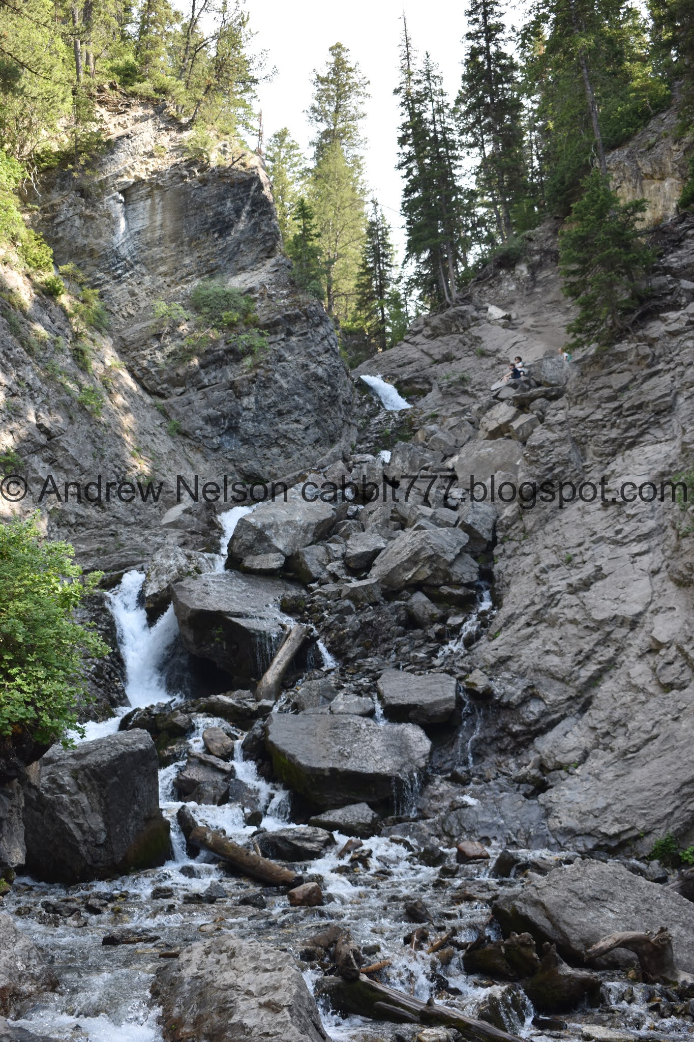
Holy crap. The waterfall without 100 people scrambling all over it! Hooray. That doesn’t happen on the weekends.
Can you see why they call it Donut Falls?

How about now.
With the trees above.

With more creek.

The main falls.
The creek is running a little lower than it has in years past, but I still wasn’t up to climbing up to the cave today. It’s cool, don’t get me wrong, but it’s a precarious climb.

In fact, it is so precarious that they put in this sign a few years back.

With more creek.

Different angle.

Pretty butterfly. Not having a lot of luck nailing down which one.

Chipmunk!

View down.

The waterfall again.

Chipmunk again.

The falls.

With the surrounding cliffs.

View down.

Eventually I thought to pull out the telephoto lens. We can see the water flowing into the hole pretty clearly here.

Splishy splashy.

One last shot before heading back down.

Okay, another one from a bit further down.

Little closer.

Looking down.

Cascades.

Down canyon.

Again.

Looking back.

The creek.

Looking out of the narrow canyon. I love the wispy tree.

I decided to take the alternate around the boulder scramble.

The ridge.

Aspens.

Crooked tree.

Super green and pretty up here right now.

Bluebells.

Down to the trail split.


More bluebells.

The creek.

Fairly large spider. Could be a tarantula.

The bridge.

The creek.

Lovely forest.

Columbine.

Trail counter. This one is specifically for winter usage.

Clematis.

Caterpillar nest.

Mixed forest.


Another columbine.

I don’t know what these are, but they are pretty.

More clematis.

Another columbine.


I believe this is a southern Rocky Mountain orange-tip.

More clematis.

Rock polished by hikers.

Columbines and clematis.

Trees.

More forest.

Another columbine.

Another. How did I miss all of these on the way up?

Heading down the final steeper part.

A trio of columbines which shows of all the fun features of the flower.

Mixed forest.

Fat squirrel.

Meer catting.

Nomming on grass.

Geraniums.

YAY!!!! An elkweed! I don’t think I saw a single one last year. This one appears pretty young.

Super pretty flower. They only bloom once.

Another squirrel.

This guy is just chillin.

Almost back to the trailhead. Forward will take you back down to Mill D and the Jordan Pines Group Campsite. The split to the individual Spruces Campsites is just above here. I haven’t done that yet.

Back down to the overflow parking at the upper trailhead.

Still super pretty up here.

Heading back down (PSP). Note the No Parking signs.

Back to paved road (PSP).

Almost down to Mill D (PSP). I noticed it was pretty swampy here. It did not normally used to be swampy here. What is going on?

Oh fun! There is a new beaver dam here. I decided to put more images of that in a separate post.

Heading down Big Cottonwood Canyon (PSP). Here is the S curve.


Storm Mountain (PSP).


Ooof, the valley is awfully hazy (PSP).
I am super happy we decided to do this trail again today. It was nice to enjoy it without the throngs of crowds, and actually see the waterfall without people scrambling all over it! 10 out of 10 squirrels today.

As for difficulty, most of the trail is pretty easy going. With one boulder scramble, which can be avoided. DR3. If you decide to scramble up to the cave, I would bump that up to a DR5.
Dogs are not allowed in Big Cottonwood Canyon. Be sure to leave Fido at home.

No comments:
Post a Comment