Corner Canyon is a pretty canyon located in Draper. The lower canyon which is a wide old dirt road path, features pretty woods, and a creek. There are a couple options to make it a loop if desired too. I wanted to get into the mountains, but not too high up yet so this was a good option to do that. We've done it before, but it's a decent hike.
Quick Details:
Length: It s about 1.1 miles to the crossroads, 2.2 out and back.
Trail Type: Out and back, loop options, connector.
Difficulty: DR3. Super mild climb.
Elevation Gain: About 400 feet.
Restroom: It looks like there are year round restrooms at Andy Ballard Arena adjacent to the trailhead.
Dogs? Yes, leashed as long as you stay on or below the Bonneville Shoreline Trail (BST) at the crossroads. Above, or east of that is watershed.
Other Info:
To Get Here:
Take i15 to the Bangerter Hwy exit and head east. Go about a half mile and turn left onto 13800 S. Take that 1.7 miles it will curve to the north. Turn right on 1300 E. Immediately turn left on Highland Dr. Go about .4 miles and turn into the parking lot. You want to park near the northern end.
Look for the tunnel under Highland Drive. The trails on either side will get you down to it.
Heading towards Mount Jordan (Passenger Seat Photography (PSP)).
Corner Canyon across Highland Dr.
The Trail:
You can descend the hill on your way to the tunnel under Highland Drive on either side of it. We were closer to the north side so down the Bunny Bradley Trail we go for a bit, which is paved.
Well, you know it is winter in Utah when the inversion starts settling in. Yuck!
About 400 feet later you will reach the signed split to the tunnel.
Before long you reach the tunnel.
Behind me is where Corner Canyon Creeks comes out. It is currently dry down here.
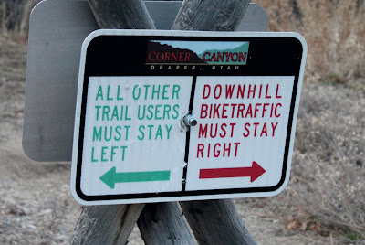
This entire trail has a fast downhill bike lane to the left, all others to the right. So, as usual stay to the right heading up. But contrary to regular trail etiquette, you will stay left when coming back down (keeping to the south side both up and down). This is to keep you safe from fast bikers.
The tunnel.
You have to work your way through this little corral thingy, then the trail resumes being a wide old dirt road.
Trail counter.
Directional sign. We want to stay right.
See? Nice wide old dirt road.
Be sure not to veer onto the Rush Trail, it is for fast downhill bikers only. But, don’t worry they have done a pretty good job at providing adequate signage to help you avoid that.
Continuing up.
Oh, this section of the Rush Trail is closed for some reason.
The dry creek bed again. At the lower crossing.
Continuing up.
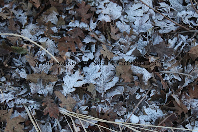
Oh fun. We’ve got some hoar frost going on. It has been cold and super humid the last few days, which are perfect conditions for it. The fact that I can see it this late in the day tells me the canyon bottom doesn’t get much sun this time of year.
The canyon again.
More hoar frost.
Another of the many reminders to stay right.
The trail again.
Another section of the Rush Trail, downhill fast bikes only.
The bottom of the Creekview Trail. which also connects to the Jungle Trail. You can use either trail to make a loop.
Winter on the right, fall on the left.
Access to the Carolina Hills Trailhead.
Across from here is the bottom of the Jungle Trail.
The middle creek crossing.
There is some ice down there.
Continuing up.
Little bit of trail damage.
Some nice forested area.
Little bit of water trickling down.
More trail signs. Original access to the Carolina Hills Trailhead. I was curious about the Sweet Caroline Trail so I looked it up and am tempted to check it out sometime. I'll probably end up back here at some point this winter so I will likely do it soon.
One of the water diversion stations.
Water heading into it.
Poison ivy warning. I have only seen poison ivy warnings here and in Hidden Hollow, but never actually seen it. However, obviously I am cautious in these areas.
Trees on the hill.
No poison ivy.
But lots of myrtle spurge which is also a noxious weed that can cause burning and blisters.
Spooky looking tree.
The upper creek crossing.
The creek, with some water in it.
The top of the Jungle Trail.
Contrail.
Continuing up.
Snowy hill.
Another section of the Rush Trail. Downhill bikes only.
Nearing the top.
Starting to be able to see the Silica Pit.
Random drinking fountain. I didn’t check, but I doubt it runs in winter.
Better view of the Silica Pit.
We made it to the crossroads. You have quite a few options here to keep going, make a loop of some kind, or just head back. FYI the cross trail is the BST, so if you brought dogs be sure you don’t go above that.
Trail markers, and a sign warning of extremely muddy conditions today. Luckily we didn’t plan on hiking further up. The lower trail was just fine though. Just a general reminder if you are actively picking up mud on your shoes, or bike tires, you are damaging the trail, and should turn back.
The silica pit.
Another trailhead kiosk.
The old road heading up towards the Coyote Hollow Trailhead and the top of the Creekview Trail. The road is also the BST heading south for a minute.
The BST heading north. This will connect to Bear Canyon a little to the north.
The old road continuing east up the canyon towards Ghost Falls.
Panoramic of the crossroads.
Okay, well that was fun but it is really time to start heading back.
Heading back the way we came up.
Just a quick reminder that contrary to what you are used to, you want to stay to the left, on the south side of the trail heading down as fast downhill bikers will be on the right. Yes, it does feel kind of weird doing it.
Landis spotted a pair of deer up on the ridge. They were so far away and small I'm not sure how he spotted them.
The creek at the upper creek crossing.
Spooky trees.
Hoar frost.
Trees and sky.
More trees.
Back down to the split for the Carolina Hills Trailhead. Stay left.
A closer view of the sign telling you to stay left on the way down.
Middle creek crossing.
Starting to see a little bit of sunset color.
Neat tree with a big nest.
More hoar frost.
The lower creek crossing.
Valley inversion.
Again.
More hoar frost.
Sign advising to use the tunnel. Technically you can scamper across Highland Drive, but there is a reason they built the tunnel so might as well use it and be safe.
This is the 2nd place we saw this sign. I don’t think they mean heavy use area so much as tighter area. Either way, they are advising downhill bikers to slow down.
Back to the tunnel.
Inside. We were being amused by the sound of our walking sticks echoing around us. It sounded a little bit like lightsabers.
The valley and inversion.
You can barely make out The Claw at the aquarium.
The trailhead kiosk.
Looking back up the canyon.
Oh, they just lit up The Claw so you can see it a little better now.
They are currently doing a Christmas light show called Lantern Fest at the aquarium so it’s a little more active than normal.
Here is a quick video.
I thought we would stop by The Tree Of Life on the way home, but sadly the lighting ceremony isn’t until tomorrow so that was a bust haha. Next time we’re in the area.
Anyway, that was a good hike for this time of year. Got a little bit of a forested canyon without dealing with too much snow just yet. We only ran into 3 or 4 other people, which is always nice too. Only 1 of them was a fast downhill biker. 7 out of 10 squirrels today.
As for difficulty, it is a really mild climb along a wide well packed dirt road. DR3.
Dogs are allowed, leashed. So long as you stay on or below the BST. Above that is watershed.
.jpg)


.jpg)


No comments:
Post a Comment