.jpg)
Twin Lakes Reservoir is particularly pretty reservoir located at the top of Big Cottonwood Canyon. The reservoir combined the former Twin Lakes, which is where it got its name. The trail features wildflowers, wildlife, a mixed forest, excellent views, and 2 stunning high alpine lakes.

Quick Details:
Length: It is about a mile up from the TH at the back of Silver Lake. So that will add about 3/10’s of a mile each way, so 2.6 out and back, plus whatever exploring you do.
Trail Type: Out and back, longer loop options.
Difficulty: This is a non stop rocky climb! DR4.
Elevation Gain: About 710 feet.
Restroom: Yes, there are flush toilets in and next to the visitor center.
Dogs? No. Big Cottonwood Canyon is watershed.
Other Info: Fee Area. As of June 2024 there is a $10.00 day use fee that lasts 3 days. There is also a weekly, and yearly option.
To Get Here:
Drive to the top of Big Cottonwood Canyon, just after you hit the 1 way loop you will see the Solitude Nordic Center on the right. If the small parking lot is full there is additional parking across the street. If that is full you will need to park at Brighton.
Once you hit the Silver Lake Loop you will want to go right, or counterclockwise as it is the shortest route to the back trailhead. Also, with the boardwalk rebuild project, it is currently the only way you can go.

Heading up Big Cottonwood Canyon (Passenger Seat Photography (PSP)).

It’s so pretty up here (PSP).

Mount Millicent as we enter Brighton (PSP).
The Trail:

Sign advising of the fee area.

Silver Lake is very, very popular and quite busy. But once you enter the back woods the crowds thin out quite a bit.

As far as I have been able to find, this peak is unnamed. But that is what we will be hiking along. You can see the trail going through the middle of the scree fields near the center.

The new board walk was not built in the exact location. You can see where the old one was here.

The final section of board walk that is being rebuilt appears to be coming along nicely. Maybe they will actually complete it this year.

Beaver dam.

Mount Millicent and the unnamed peak. Twin Lakes is in the saddle between them.

First view of Silver Lake.

The new fishing dock/bridge over the outlet.

Beaver Lodge.

Silver Lake again.

Clear water.

The outlet with the beaver lodge again.

Upstream with Silver Lake.

Pretty forest.

Silver Lake and Mount Millicent.

About 3/10ths of a mile later we reached the back trailhead. Here is the kiosk.

I still have no clue why they dug this out last year.

Beautiful mixed forest.

The four way split. Right is a winter only trail, forward leads to Lake Solitude (also a good hike) left to Twin Lakes, so left it is.

There is usually a sign. I have noticed that late in the season they take them down though.

Yay! First columbine of the year! I managed to keep one of these alive in my garden this year. Here is to hoping it comes back next year.

Two more.


Geraniums.

Pretty forest.

More geraniums.

Pretty purple peas of some sort.

Something yellow.

Pretty blue penstemon.

Pretty forest.

Some ruins of some kind of structure. I assume an old cabin.

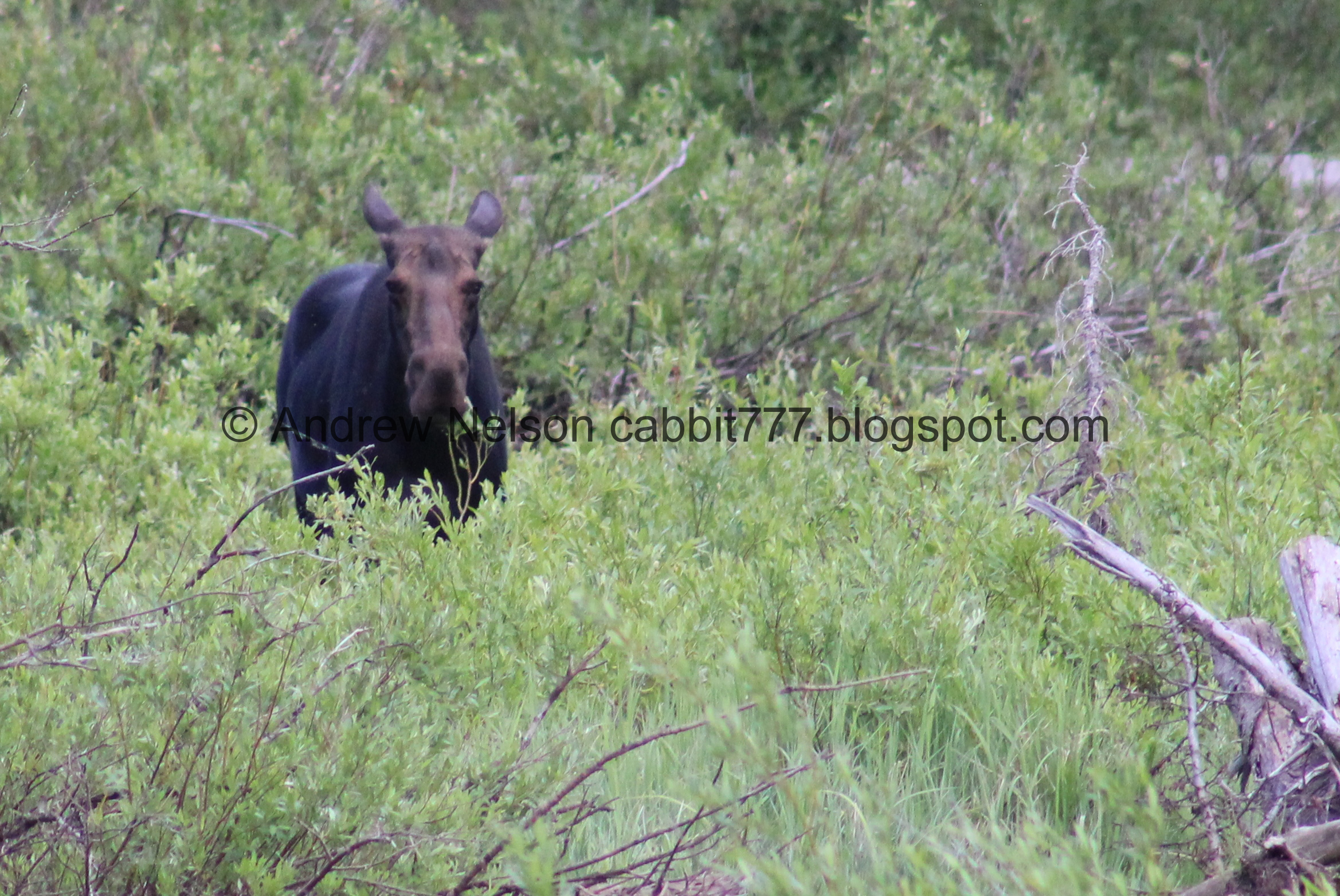
Well, hello there! We were really hoping we would see a moose today and well, here we go. Hello cutey!

I felt like we were a liiiitle closer than I would like, and she did look at us a couple of times, but then went back to doing moosey things so I guess we were not tooo close.


So majestic.

She started making her way towards us, so we scampered up the trail a little further.

Working her way up the hill.


Thankfully, she decided to cross the trail instead of come up it towards us.

Then she disappeared into the woods. It was so cool to see her!

Back to the trail.

I love this random damaged pine. It looks like it lost its leader branch (possibly due to a lightning strike? I'm not sure) but then another branch took over as the leader branch. Tree's sure have an excellent will to survive.

More penstemon.

More peas of some sort.

More yellow flowers of some sort. I am absolutely terrible at identifying many petaled yellow flowers.

Bluebells.

Up to the scree fields. This is just short of halfwayish.

High elevation scree fields are a good place to look for pika’s. They are adorable little rodents.

Scree fields again.

Silver Lake below. This is one of my absolute favorite viewpoints along the Wasatch Front.
.jpg)
Panoramic.

We heard a noise behind us and found a deer making it’s way down the scree field. Alright deer, you do you.

I mean, I guess they were built for this, but there had to be a better way down.
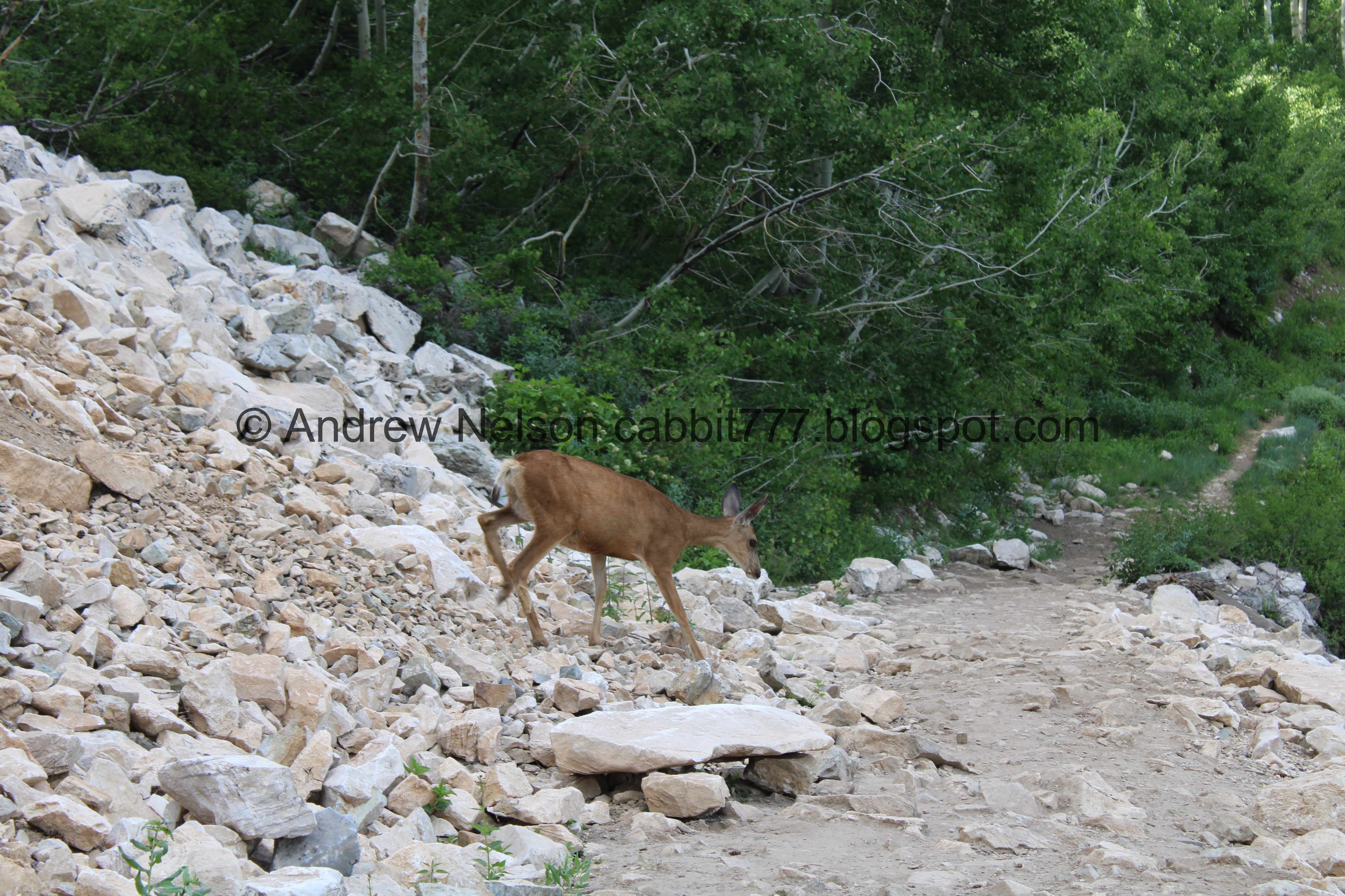

Then she decided the trail was better.

Silver Lake again. Wow.

With peaks.
.jpg)
Another panoramic.

It is so nice and calm right now.
.jpg)
Another panoramic.

The lake again. The boardwalk looks pretty much done from up here.
.jpg)
Another panoramic.


Huh. It looks like the scree field has shifted a little this year.

The lake again.

Closer.

Scott Hill (easily recognized with the Mickey Mouse shaped mine tailings) and the road up to Guardsman Pass (far right).

Another columbine.

Some clematis.

Scott Hill again.

Some small white flowers.

Then we get a very short break from the climb. Phew! Also, this is really about the halfway point.

I am normally a stickler for staying on the main trail. However, this side path that parallels the main trail is much less rocky and is quite established, and I have found it to be much easier on the feet so, we take the thinner side path up for most of the last stretch.

Some paintbrush.

More penstemon.

There is one exception where I move over to the main trail near the big rock. The side trail is a little steeper, and well, I slipped on it one time, so.. I deal with the rocky trail through here.

The big rock.

Wallflowers. I successfully grew these in my garden last year, but they did not come back this year.

More rocky climb. Oi.

More bluebells.

Less rocky option to the right.

Another wallflower.

Pretty hillside.

Another short break from the climb.

Another pretty hillside.

Pretty yellow flowers.

Mount Millicent.

Looking back towards Scott Hill.

The final push. Oof.

More paintbrush.

The Twin Lakes Dam.

Just around the tip of the dam.

Then we can see the lake… whoa…. It is super low right now! I suspect they must have some dam maintenance to do but wow.

Super low.

In fact it is so low that you can see the original Twin Lakes! Wow! There is a pretty loud waterfall between them.

The super low lake again.

Cute yellow flowers.

The lake again.

The back lake and the little waterfall again.

The dam.
.jpg)
Panoramic of the lake. Mount Millicent, Mount Tuscarora, Mount Wolverine (I think) and... Well, I guess I don't know that one.

The lakes.

We decided to descend down to the significantly lower lakes. Tree stumps that would normally be submerged.

The waterfall between the 2 lakes.

Large patch of snow.

Mount Millicent, Mount Tuscarora, and Mount Wolverine I believe.
.jpg)
Another panoramic.

I am terrible at gauging height but I would wager I would be under at least 20 feet of water right here.

The lake again.

Huge boulders in this scree field. It looks like this is just a (normally) underwater extension of the scree field above, which we will get to soon.

Some cans that have almost completely rusted away.

Climbing back up. It is interesting to see the various rings of water levels.

Nearing the regular high water line.

The big scree field. I often see pika here so we decided to hang out for a minute and look for them.


We we saw one for a brief moment.

The trees are kind of in the way, but you can see the 2 lakes a little better from here.

Some young conifers and aspens.

The lakes again.
.jpg)
Another panoramic.

The dam again.

I think this is a float that prevents debris from going out the overflow outlet.

More rings.

One last parting shot before we head back down.

The overflow spillway.

The other side of the dam.

Looking across the canyon.
.jpg)
Panoramic.

Some purple penstemon.

The creek coming out of the bottom of the dam. Fun Fact: All of the Brighton Lakes are considered the headwaters of Big Cottonwood Creek. Including Twin Lakes, Lake Solitude, Lake Mary, Lake Martha, Lake Catherine and Dog Lake.

Continuing down.

A sad looking glacier lily. All of the glacier lilies up here seem to be dying.

Mount Millicent.

A bunch of sad glacier lilies.

Little patch of trees.

Into the woods!

Cliffs above.

The 2 parallel trails.

More cliffs.

Continuing down.

Scott Hill.

Pretty yellow flowers.

Wallflower.

Bluebells.

Back down to the big rock.

I think these are not quite mature Sulphur flowers, but not 100% sure.

Another pretty one.

More forest.

Forget me nots.

Paintbrush.

Bluebells.

We took a side trail out to the edge which offered this view of Silver Lake below.
.jpg)
Panoramic.

Nearing the scree fields again.

Silver Lake again.

Again.

Closer.
.jpg)
Panoramic.

Pika.

Another.

Silver Lake again.

Some kind of mint.

Pretty flowers.


Pretty aspens.


More penstemon.

The damaged conifer.

Back down to the old cabin ruins.


More aspens.


Columbines.

Back down to the 4 way split. Right will get us back to the trailhead.

The water coming down the trail is almost a small creek.

Geraniums.

More yellow flowers.

Back down to the complete zoo that is the Silver Lake Loop. Sometimes I like to do the rest of the loop, or as much as I can, but today I wasn’t feeling the crowds.

Some corn lilies that haven’t bloomed yet.

Silver Lake with Mount Millicent.

Again.

Back to the fishing dock/bridge over the outlet.

What do we have here?

Another moosey friend! Or, possibly the same one we saw earlier just wandered over here, either way, Yay!

Again.

Beaver lodge.
We are definitely far enough away, but every once in a while she did look up at us.

Back to doing moosey things.
Eventually we decided to wander down the boardwalk to see if we could see her better from a different vantage.

Eh, not too bad.

The beaver dam while we’re here.

Back to our moose friend.

Just getting her munch on.

…and wandering.
Well she meandered into some heavier brush and I didn’t get any other decent shots.

The meadow.

Mount Millicent again.

Last section of boardwalk that is being replaced.

Fancy new sign.


Some iris. I am not sure if they are wild or planted. However, they are native so I bet they are wild.

Penstemon.

Mount Millicent from the parking lot.

The peaks towards Brighton.

Scott Hill and a random crow.

Heading back down the canyon (PSP).

Nearing the mouth (PSP).

Downtown across the valley (PSP).

Bonus shot of The Old Mill (PSP). I am being quite sentimental about this old building as it appears to be under threat of being torn down to build more townhomes :(. You can get closer to that walking along The Big Cottonwood Canyon Trail.
Well, that was fun! It was a bit of a climb, but didn’t kick our butts as bad as it has in the past. Silver Lake was a complete zoo, but once we hit the back trails we only ran into a few people. I do prefer when the reservoir is full as it is a stunning blue lake! But, it was kind of neat to see the closest representation of what the original lakes looked like before the dam was built so, that was cool too. Going with 9 out of 10 squirrels, losing one for how tough it is.
As for difficulty, this is a grueling, rocky climb. DR4.
Dogs are not allowed in Big Cottonwood Canyon due to watershed restrictions. So be sure to leave Fido home.

No comments:
Post a Comment