Cecret Lake is a stunning high alpine lake located above Alta. The trail features a beautiful forest, pretty meadows, wildflowers, a creek and several small streams, and of course a stunning emerald green lake below striking peaks. This trail is short and pretty easy with a stunning reward at the end, so it can be very busy most of the time.
We are in the awkward time between the wildflowers being pretty much done, and before the autumn color change has really started. So, I wasn’t really sure what I wanted to do today, so we settled on this one. Even though we had done it just a few months ago. It is one of the trails we tend to do fairly often though.
Boy, we sure have been spending a lot of time in Little Cottonwood Canyon this summer.
Quick Details:
Length: About 1.6 miles out and back. With the option to add about 6/10ths of a mile around the lake.
Trail Type: Out and back, or balloon.
Difficulty: Its a pretty mild climb for the most part with some mild switchbacks near the end. DR3.
Elevation Gain: About 440 feet.
Restroom: Yes, there are pit toilets at the trailhead.
Dogs? No. Little Cottonwood Canyon is watershed.
Other Info: There is a $12.00 fee to use the Summer Road (as of 2024). You can avoid that by hiking up from the Albion Base which will add about 1.5 miles each way. So 4.6 out and back.
To Get Here:
Drive to the top of Little Cottonwood Canyon. Pay the fee to use the Summer Road and continue up to the end of that. Park and hike.
Roadside sunflowers (Passenger Seat Photography (PSP)).
Starting to see some more fall colors starting to come in (PSP).
The little toll booth (PSP).
Devils Castle (PSP).
Heading up the Summer Road (PSP). It is dirt, but very well graded, pretty much any car should be fine on it.
After the first switchback (PSP).
A little more fall color (PSP).
Devils Castle, Sugarloaf Peak, and Greely Hill (PSP).
Continuing up after the 2nd switchback (PSP).
Passing by the Catherine Pass Trailhead (PSP).
The Albion Meadows looking pretty barren of flowers (PSP).
The last stretch (PSP). As far as high mountain dirt roads go, this one is really not so bad. The only part that makes me a little nervous is the part below the Catherine Pass Trailhead.
We made it to the parking lot. Phew!
Uh oh. Those clouds look a little foreboding. There wasn’t any rain in the forecast for today but uh, yeah, we absolutely got rained on. It wasn’t too bad though and actually meant less crowds so I will call it a win today.
The Alta Store. It was closed today. I am not sure if they are done for the season or not though.
The Trail:
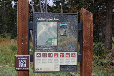
Trailhead kiosk.
Crossing over Little Cottonwood Creek.
Upstream.
Downstream. It is quite a bit lower than the last time we were up here.
The original trailhead sign. Which, is quite out of date. The trail length is about double what they list here. We have learned the forest service does not appear to be to inclined to replace signs, even if a trail has been seriously rerouted *cough* Catherine Pass *cough*. So I suspect this trail was rerouted at some point too.
Paintbrush.
Western coneflower.
Some asters of some sort. See, there are a few wildflowers left to enjoy.
Supreme ski lift.
Forest.
View down.
The first of five streams. This one has dried up this late in the season.
Sign about limiting your impact. Basically stay on the trail, don’t swim, don’t pick wildflowers, don’t harass wildlife.
Sugarloaf peak.
Gnarly tree.
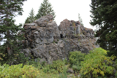
Geologic forces.
Devils Castle.
The 2nd little stream. Also dried up this late in the year.
I love the large boulders that have come down off of Devils Castle.
Well poop. We were hoping on coming back down that way, but we did obey the sign and didn't.
This part of the trail is also a road to access private cabins. So sometimes you might encounter a car. In all my years of doing this trail I am pretty sure this is only the 2nd or 3rd time I have encountered a car. But obviously, it can and does happen.
The 3rd little stream, 1st one that is still flowing. It is easier to cross while it is this low though.
Trail split. The trail is to the left, private road to the right.
A sad little lupine.
Devils Castle again. I just noticed the patch of snow that is almost always on it is about gone. :(
Devils Castle and Sugarloaf Peak.
Devils Castle.
Sugarloaf Peak.
An explosion of color. We are a few weeks past that right now. But it is pretty if you catch it right.
4th stream, 2nd flowing one.
Forest.
Enjoy wildlife from a distance.
More forest.
5th stream crossing. 3rd that is still flowing.
Then we enter the granite slabs area.
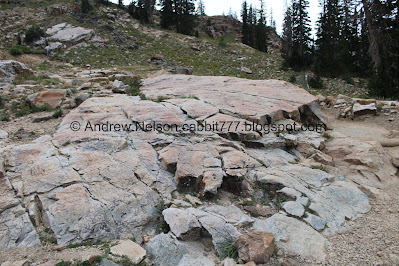
Large slabs with glacier scrapes across them.
Some deer friends.
Devils Castle.
Deer friends.
Continuing up. I think it was about here we started to get rained on.
Looking back towards Catherine Pass.
The narrow gully that Little Cottonwood Creek comes down from Cecret Lake.
More glacier scrapes, and the hill we need to climb.
The switchbacks.
Panoramic of the surrounding peaks. Patsy Marley, Mount Wolverine, Mount Tuscarora, Catherine Pass, Point Supreme, East Castle, Devils Castle, Sugarloaf Peak.
24 hours to a faucet. All of the signs have been updated and replaced this year. This sign replaced the sign that identified the peaks, which is a bit of a shame.
Glacier scrapes.
Mine tailings.
Onto the first switchback. It started to rain a little harder and I questioned whether we should call it or keep going. We decided we were close enough to just push on.
Little mine.
Catherine Pass.
Continuing along the first switchback.
The 2nd, or middle switchback.
The 2nd or middle switchback.
The 3rd or top switchback. This part usually makes me nervous, and you would think with the added rain it would have been worse, but for some reason I was fine today. The lizard brain makes no sense sometimes. I guess I was more distracted by the rain than the heights.
The 3rd, top switchback.
Then the trail turns upwards towards the lake. Almost there!
More asters.
Early changers.
We made it to the lake! Still being rained on though. Oi. That is Sugarloaf Peak looming above at 11,051 feet.
Panoramic.
The lake again.
Cecret Lake.
Panoramic.
Devils Castle.
The dam.
Salamander.
Nice clear water. We didn’t find as many salamanders as we normally do, but it is getting late in the year.
The lake and Sugarloaf Peak. The rain is letting up. For a little bit anyway.
Another salamander.
The lake again.
Another panoramic.
Beautiful purple penstemon.
The lake again.
With Devils Castle.
We wandered around a little bit, and I considered walking around the entire lake again, but I was worried it would start raining again, so we decided not to.
More early changers.
We found a random little pond that we had never noticed before. Might just be a rain puddle haha.
Old metal part.
One last shot of the lake before we head back.
More asters of some sort.
More.
More early changers.
Heading down the switchbacks. Of course the rain decided to start up again now.
Catherine Pass across the way.
The top switchback.
View below.
The middle switchback.
Heading towards the lower switchback.
The lower switchback.
Mine tailings.
The mine.
With the flash. Its more narrow than I would like so I have no idea how deep it goes.
Now we head across the granite slabs.
Skyrocket.
Devils Castle in the rain.
Looking back at the switchbacks.
Glacier scrapes.
The surrounding peaks again.
Devils Castle.
More glacier scrapes.
The 5th stream (from the beginning).
Forest.
The 4th stream.
The 3rd stream. We we’re kind of rushing down to get out of the rain, so I didn’t take a lot of pictures on the way down.
Rainy forest.
Like I said, I wanted to go down the alternate trail, but we couldn’t today. Oh well, next time.
Pretty pink asters.
The 2nd stream which is currently dried up.
Devils Castle again.
Well, the sun is shining out on the Catherine Pass Trailhead.
Boulders, and a wet lens haha.
The 1st stream, which is also dry this late in the year.
Western coneflower.
Finally the rain let up and we have some sunshine. Of course, now that we are near the trailhead.
Forest.
Lots of arnica.
Bridge over Little Cottonwood Creek.
Upstream, where the Albion Basin Campground road goes over it.
Downstream.
More early changers.
Asters.
Arnica.
More asters.
View down canyon.
Heading down the Summer Road (PSP).
Again (PSP).
Well, we got rained on, but didn’t get totally soaked down to the bone, so that was nice. Plus the rain did chase off most people so it was kind of nice and quiet today. Normally this is a very busy trail. It is an absolutely beautiful trail leading to beautiful lake. I am gonna remove a squirrel for terrible parents that don’t teach their kids trail etiquette. There were a LOT less of them today than usual, but they were still there. 9 out of 10 squirrels.
As for difficulty, it’s a pretty mild climb, even the switchbacks aren’t too bad. DR3.
Dogs are not allowed in Little Cottonwood Canyon, so be sure to leave Fido home for this one.
.jpg)


.jpg)


.jpg)


.jpg)


.jpg)


.jpg)


No comments:
Post a Comment