.jpg)
This section of The Jordan River Parkway was pretty enjoyable as well. There are parts that go by some businesses and some homes, but there are long parts that seem pretty wild. There are a couple interesting things to see as well. It’s supposed to start snowing soon so we weren’t sure if we would be able to go out on our normal Sunday.
Quick Details:
Length: The map says this section is 2.1 miles long. I think it was closer to 2.3 so 4.6 out and back or 4.5 balloon. we ended up doing about 4.8 balloon with a wrong turn and a little exploring.
Trail Type: Out and back, slightly shorter balloon option.
Difficulty: DR2. Its paved and generally flat.
Elevation Gain: About 30 feet.
Restroom: I think there is one at Redwood Trailhead Park. I know there is one at the James Madison Trailhead, however it is enclosed in the Tracy Aviary Jordan River Nature Center which is open from 9 - 3 Saturday and Sunday.
Dogs? Yes, leashed.
Other Info: Cities: South Salt Lake, West Valley. JRP Mile Markers: 33 and 34.
To Get Here:
Take i15 to exit 303, 33rd south. Head west for approximately a mile, turn left into the Tracy Aviary Jordan River Nature Center / James Madison Trailhead.
It looks like the parking is for the nature center only, but this is an official trailhead and park.
The Trail:

The trail starts on the west side of the parking lot, just behind the restrooms. Also, it seems counter-intuitive since we are heading north, but you want to go left here. Right will get you there but you will have to finagle getting around a fence, and hopping off a short wall.

James Madison Trailhead sign. We’ll swing right here.
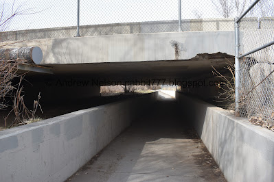
Heading under 33rd south. This is where I left off last time.
This is why we had to left at the 1st junction. If you go right you will have to hop off of the wall you see to the right.

Nice little forested part.

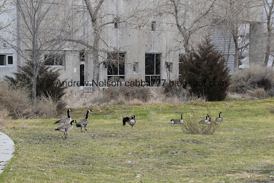
Geese.
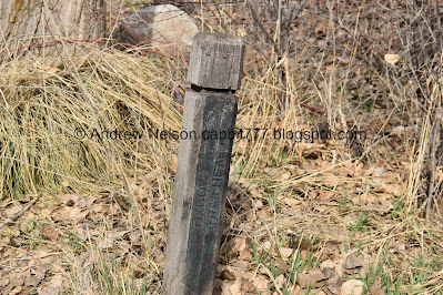
Old trailhead marker. I don’t know if it still is one. There are some businesses here now. It's not on the map either.

Old barn.

Back into the woods.

Lots of ducks, and I think I see a coot or 2 in there.

Passing by the Salt Lake County Oxbow Jail.

We saw a lot of signs of beaver activity, but no beavers, or lodges.

This appears to be the outflow of some random unnamed pond to the west.

Ducks and an American coot.

More wildness.
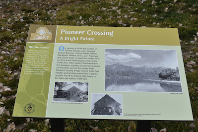
Apparently this was a spot where early settlers crossed the Jordan River and started settling on the west side.
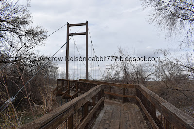
Yay! a suspension bridge! This is only the 2nd one that I am aware of in the Salt Lake Valley. The other one being Bear Canyon Suspension Bridge.
Note: This is the wrong way, this is a connector trail. However it does lead to a couple neat things so I am not mad we took this random side trail. Some of the JRP signs are not exactly clear. Go forward to stay on the main trail, but honestly, this little side trail is worth it.

I did some digging and found a bridge enthusiast. According to his page (external link), there are 12 suspension bridges in the entire state. But I know he is missing one so 13. The 2 that are in Salt Lake County are pretty new, but there is an even newer one located at Creekside Park in Bountiful. Of course, this is just an enthusiasts page, so it is not definitive.
I guess I am kind of becoming a bit of a bridge enthusiast myself, between suspension bridges, covered bridges, and truss bridges haha.


I’m going to tag this post with my #oddities tag since they are so rare around here.

Downstream.

Approximate middle.

Upstream.

The whole thing.

This was erected in 2013.
A partnership between the state of Utah, Salt Lake County, West Valley City, West Valley City Historical Society, The Jordan River Commission, and the Ralph L Wadsworth Company (That last one sounded super familiar, and I just confirmed that company also worked on the Bear Canyon Suspension Bridge).
The bridge commemorates the part of the river that the first settlers of the west side crossed in 1848
Joseph and Susannah Harker were the first over river and built a log cabin hear here.
In January of 1849 another group of pioneers crossed over the ice here and built dugouts and cabins.

Ooh, a neat old cabin.

It’s in pretty bad shape.
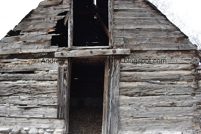
Small glimpse inside.

From the side?
We were just starting to complain that there wasn’t any information on this when we found the sign. I guess this side is considered the front.

Unfortunately it is quite faded. We picked up the word Harker, and between that, and the previous signs I am going to guess (note GUESS) this was the Harker Cabin? I might be wrong. I will see if I can clean this up a little. Now I can see something about a granary so perhaps that is what it is? Oh, I was able to make out that they believe it is the oldest standing structure in West Valley City. But there is definitely more digging required.

Geese.

The Utah Cultural Celebration Center. I’ve been there for a work event, but otherwise I don’t know much about it, other than the obvious that it is meant to celebrate the various cultures we have here.
At this point we realized this must be a neighborhood connector trail, so we turned around. As far as wrong turns go though, this was a fun one with some neat history to enjoy. This took us about .17 miles off coarse out and back, which I removed from the mileage I posted.

Back to the suspension bridge.

Cool bridge. It uh… bounces a bit, and creaks and groans, which is a bit unnerving. But I trust it is safe.

Back on the main trail.

Now I am 100% confidant we are on the main trail as we passed by mile marker 33.

Mountains.

Another bridge. We will be crossing that one in a minute.

An alternate trailhead. This one is one the map. There appears to be street side parking here. This would be a good spot to just do the loop.

American coot.

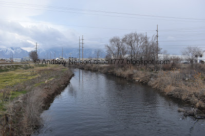
The river again.


Trail split. Left is the main Jordan River Trail. Right is the Mill Creek Loop Trail. We returned that way, but went left here.

Crossing over the Jordan River.

Downstream.

We dubbed this Duck Island.

Honestly, I think we have weaved in and out of West Valley a bit already through this section, but here we are officially entering West Valley.

Wildlife on the Jordan River.
You will almost certainly see mallards. You might catch a beaver (I definitely saw signs of them) you might even see a mule deer, or a garter snake.

Nearing the Redwood Nature Area.

The river.

Looks like there was a fire here at some point.
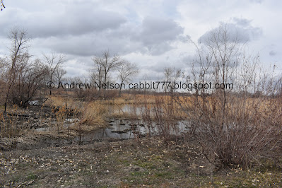
Little wetland.

Another panoramic.

West Valley’s benches are pretty meh too. It’s been kind of fun to see what the benches look like in each city.

More wetlands.

The Redwood Nature Area.
They removed a bunch of invasive species and restored it as much as they could for the local flora and fauna. I love seeing these things.
There is an additional mile loop around it if you feel so inclined, as well as a spur out to Decker Lake.

Another pond.

Mountains.
Somewhere near here is the Mill Creek Confluence on the other side of the river. Unfortunately, the trail is far enough away from the river that we did not see it. However, we did see it on the return trip.

Restoring Wetland Habitat.
The sign claims they cannot restore the wetland floodplains (well they could, but it would upset land owners near the river) however they can restore pockets of it, like beads in a necklace, as the sign states. So I will take the small win. pockets of wetland are better than nothing. It’s nice to see that enough people care about fixing the mistakes of the past.

The pond again.

Ways of a Wild River:
This sign talks about the horrible effects that became of trying to control a wild river. Early Utahns straitened the river here and did not anticipate the effects of doing so,

The pond again.

Red winged black birds.

Another sign talking about how they have restored the area.

The Decker Lake Drain. From what I can tell Decker Lake is a manmade lake, I am still trying to figure out it’s source, but here is where it flows out to the Jordan river.

This part of the trail follows a Trax Line.

Mountains and the Decker Lake Drain.

Panoramic.

Where the Decker Lake Drain meets the Jordan River.

Mile Marker 34.

Approaching another bend in the river.

American coots.

You can see all the way to the University of Utah Block U.

River bends.

There is a lot of waterfowl poop through here… yuck.

Holy pidgins batman.

Looking back at the straitened section.

Back to the curve.
First wildflowers of the year.

The river and mountains.

The Khadeeja Islamic Center is a neat building.

River and mountains.

This looks like something leftover from livestock. I suppose there might have been a farm here before.

River again.

Mountains again.

We made it to the Redwood Trailhead Park. Yes, we did take a wrong turn at some point, but even accounting for that, this was a little longer than the map lead me to believe. But at only 2.3 miles, it wasn’t too bad.

Closer shot of the geese.

There is a giant frog in this park! hah!

Bridge, we will be returning that way.

Fishing docks.

Trailhead sign. This is where we’ll pick up the trail for the next section. I also took a moment to confirm that the Mill Creek Loop connects here. It does.

It is not signed on this end, but this is the other end of the Mill Creek Loop, so we will return via the other side of the river.

Upstream.

Downstream with a UTA Trax hub.

The trail on this side continues north, but it appears to dead end at the train tracks.

Heading back south.

You can see the higher water level lines here.

The Islamic Center again.

Back to the S curve.

The Islamic Center again.


I don’t know who this Turb is, but someone cared enough about him to memorialize him. I think that is pretty neat.

Hrm. The clouds are starting to look a bit ominous.

Mile Marker 34 on the other side of the river. Since this loop is not the official trail there are no mile markers on it. Well, almost none.

The Decker Lake Drain again.

Geese.

Geese on the water.

Various nest holes. On a previous section, I learned that bank swallows and kingfishers build these kind of burrows into high river banks.

Random drinking fountain and historical marker.

Hastings Cutoff - Utah Outlet (Jordan River)
Left camp late this day on acct. of having to find a good road or pass through the swamps of the Utah outlet. Finally succeeded and encamped on the East bank of Utah outlet making 5 (miles).
James F. Reed. August 23rd, 1846
Utah Crossroad Chapter - OCTA
This is only the second marker like this I can recall seeing so far. I’m kind of surprised there aren’t more.

Oh that is cool. Looks like the local business, Radius Engineering erected the drinking fountain and foots the bill for it. That is awesome. I’d love to see more businesses do something like this.

Looking across to the Redwood Nature Center.

American coots and geese.


Another section the geese seem to like.

Goose down anyone?

The Mill Creek Confluence.

Bridge over Mill Creek.

Geese, coots, and is that a wood duck?

Ducks and coots.

The Mill Creek Confluence. Not as terrible as the Big Cottonwood Confluence, not as nice as the Little Cottonwood Confluence. But still neat.
Looking upstream on Mill Creek. Other than some trails in Mill Creek Canyon I can’t think of anything off the top of my head that is around this creek that we have been to. Odd. So of course I followed it along the map back up to the canyon. Unlike the Jordan River, there are only a few small parks along it's course.

Back down to the confluence.
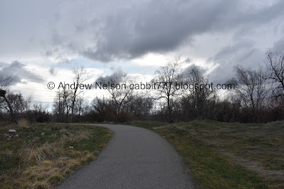
Moody skies.

I found a thin trail back to the Mill Creek Confluence. I was happy to get better look but meh.
I removed this 1/10th of a mile side excursion from my final mileage.

More signs of beaver activity.

Looks like there was a fire here too.

This part is along some businesses which is kind of blah.

Nearing the end of the loop.

One of the Olympic Gold Medal Miles. Not sure where this one starts, but here is the mile.

Back to the main trail. Phew, I was a little worried about it connecting again.

Re-entering South Salt Lake. (Note I took this on the way out. It would require backtracking about 5 feet to the right from the previous picture).

There is a picnic table here in case you packed a lunch.

The river again.

American coot.

Another old trail sigh pointing towards the 33rd south trailhead, which I believe is now the James Madison TH.

There are quite a few desire paths that will make shortcuts. We did not use any of them today, but I will warn you that these may lead you to homeless camps. Again, not anything wrong with that, they need somewhere to sleep too, and if I was in their situation, I would seek somewhere like this out as well. Again, so long as they leave me alone, I will leave them alone.

Entering a forested area again.

Mile Marker 33.
There was a homeless guy picking up cans here. I don’t know why, but he felt the need to explain what he was doing. I was just like, good on you man. I don’t care why you are doing it, but you are picking up trash, so keep up the good work. And then we kept on moving. See, they are just human beings trying to survive how they can. The few encounters I have had with them have been pretty mild. But I do know some of them can be unpredictable and dangerous. If you are worried, have some mace handy. But please, only use it if you really feel threatened. Most of them are really harmless and a lot of them are well, friendly. It doesn’t cost you a thing to be friendly in return.

The neat suspension bridge again.

Another desire path/shortcut.

More beaver activity.

The suspension bridge again.

Nice forested section.
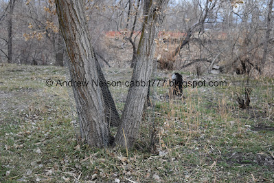

I somehow didn’t notice this on the way in, but it appears they are trying to deter the beavers on most of the trees through here with chicken wire.

I am not 100% sure, but I think this might be related to beaver activity as well.

Some ducks on the path.

Ducks.

Yes. this sign will do. Of course the homeless will obey it.

Back under 33rd south.

Back to the Tracy Aviary Jordan River Nature Center.

Crazy storm moving in (PSP). I am super glad we got home before it started. It came in like a freight train, violent and crazy.
I really enjoyed this section! Lots of interesting things to see, including 1 of 2 suspension bridges in the valley, an old cabin, 2 confluences, and of course I always enjoy a loop. It also was not too busy, we only ran across a few people today. The only downside were a couple homeless people, but I mean, where else should they go? So that didn’t bother me too much. 8 out of 10 squirrels.
As for difficulty, it is pretty flat and paved. DR2.
Dogs are allowed, but should remain leashed at all times.

No comments:
Post a Comment