.jpg)
Lower Bell Reservoir is a surprisingly scenic reservoir that isn’t too hard to reach. The trail features the reservoir nestled beneath some pretty granite peaks. Some beautiful forest, as well as some nice views of the valley below.
Last time we were here was literally days before this new trailhead opened, and well, I have been wanting to come check it out since. The new trailhead is a smidge shorter, and saves a little bit of the climb from the Granite Trailhead.
The weather forecast for the weekend was not promising and we were not sure we were going to get a hike in, however they were wrong about today, and we found a window that looked promising, so we jumped on it.

Quick Details:
Length: It is about .63 miles up to the reservoir. Then we did 1.08 around the reservoir and .68 down (we did a small side trail) for a total of 2.39 miles
Trail Type: Balloon, or out and back. Loop option but that would include walking along busy roads.
Difficulty: DR3. It’s a bit of a climb, but not too bad.
Elevation Gain: About 600 feet.
Restroom: Yes. This new TH has flush toilets.
Dogs? No. Bell Canyon is watershed.
Other Info:
To Get Here:
Take the 90th south exit from i15 and head east up to Wasatch Blvd. Turn right. Go about 600 feet and turn left. Head up the hill. There is a big parking lot at the top, and a smaller lot just below. Both access the trail, but the upper lot is shortest.

It’s gloomy, but so far dry (Passenger Seat Photography (PSP)).


Some pretty trees along the road (PSP).

Looking up Little Cottonwood Canyon (PSP).
The Trail:

The trailhead sign.

The trailhead from the upper parking lot.

The new upper parking lot. This new trailhead opened on 5/26/22. It has new flushing toilets and running water. It will eventually include picnic areas, and from the sounds of it a pavilion. They are also working on a little nature trail. The new trailhead has about 130 parking spots, which I am a little torn about. On the one hand, yay, we can park, on the other hand, the already very busy trail will be busier as the people that were previously turned away due to no parking will now stay. Eh, overall its a good thing.
The land was sold to the city from 2 of Sandy’s earliest resident families at a discount, on the condition it became a community resource. Which is wonderful that it was not developed.

Little Cottonwood Canyon.

The new section is nice and almost like paved.

However, this isn’t a completely new trail. It connects to the preexisting Granite Trail, which is quite rocky and a bit of a climb.

Little bit of color.

The hill we need to climb.

Mountains to the north.

Some color at the base of Little Cottonwood Canyon.

The valley below.

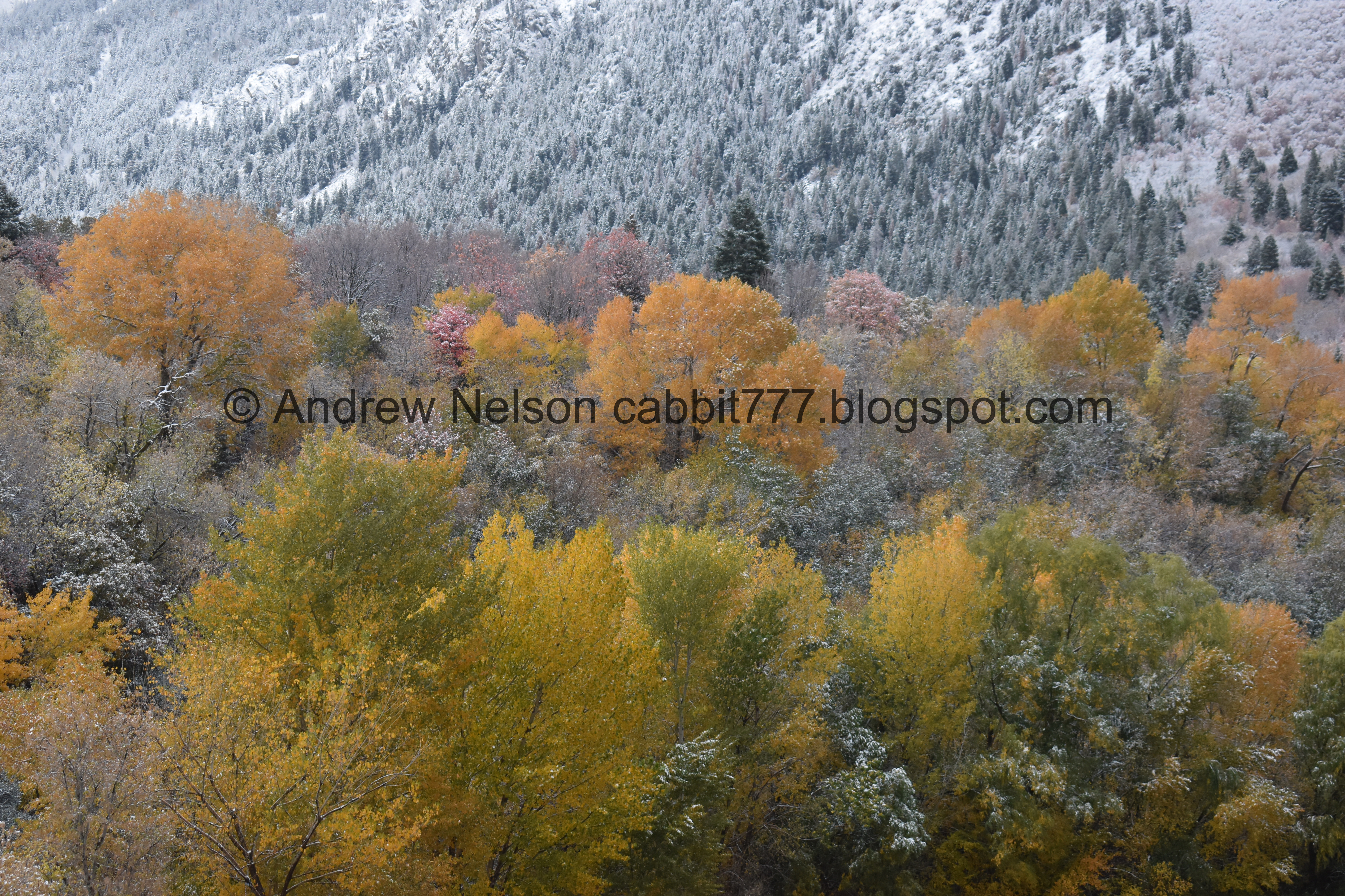
Some color and some snow from the recent storm.

Looking down on the new parking areas.

The valley below.

Storm at the south end of the valley.

A pretty purple wildflower still hanging on.

This boulder looks like it could go any minute.

More snow.

At about a quarter mile, you reach the top of the ridge, where you get a break from the climb for a minute.

More color.

The small canyon we have to cross to get cross the next ridge to the reservoir. You can see the small trail just above the service road. It looks further than it is.
I apparently did not take a picture, but there is a brief section of down.

Some pretty purples.

Back to the climb.

Stormy skies. Looks like it might be raining out west. Glad we went east today, we considered an option out west.

Snowy trees.

A little bit of orange.

Some faded reds.

Couple of rocky sections.

Downtown and the short trail down from the previous ridge.

The higher we go the more snow we are seeing.

A little bit of color below.
.jpg)
Panoramic view.

They have added a bunch of these little trail markers at each quarter mile from the new trailhead.

More snow. Luckily it wasn’t very muddy.

Snowy trees.

Looking north again.


At just .63 miles we made it to the reservoir!

After a couple of years with it being low, I think due to maintenance, it is nice to see it full, particularly during a drought.
.jpg)
Panoramic.

Upper Bell Canyon. We’ve only made it to the lower waterfall, which is really pretty. but there is also an upper waterfall and upper reservoir.

The reservoir again.
Some frosty color.

The valley again.
.jpg)
Panoramic.

Another precarious looking boulder. I definitely don’t want to be around when that thing goes.

The canyon that the Boulders Trail takes you up. I guess it's probably still Bell Canyon.

The reservoir again.

Some color by the outlet.
The reservoir again.

The reservoir is pretty full again, almost 10 feet according to this meter.
.jpg)
Panoramic.

The upper canyon again.

Some color above the outlet.

More color.
.jpg)
Another panoramic.

Frosty color.
Well, this was my intended destination for the day, due to thinking we had just a short window. But, things were looking good, so we continued around.

Looking down the outlet canyon. As I mentioned this is where the Boulders Trail comes up.

More color.

It feels a little early to be walking around a winter wonderland.

Puddle reflection.

Looking towards the upper canyon again.

Snowy trail.

Now we are on trail C? Looks like that is the Lower Bell Canyon Reservoir Back Loop Trail.

View to the south.

Trail split. Right leads into Dry Canyon, which I know they are working on building the BST across. Left heads around the lake. We went left.

The reservoir from the south.

More winter. Oi.

Another trail split. Left is a more direct, and shorter loop around the lake, which we probably should have done, since we were looking for more color. But, we wen right which leads to the Bell Canyon Spillway.

Again, more winter than I anticipated.

Another short climb.

The upper canyon again.

Little closer.

A tale of two seasons.

Some color hiding under the snow.

A little better color.

Now we are on Trail D, which is the Lower Bell Canyon Reservoir to Bell Canyon Falls trail. This looks like it just connects to the main trail eventually. We’ve never made it that far though.

Some yellows.

Some purple hiding under the snow.

The Bell Canyon Spillway. I’m not quite sure what this is, but it does have a bridge over the creek for a safe crossing.

Little bit of color.

The creek.

More color.

After crossing the creek we are heading back down.


Puddle reflections.

Starting to get a little gloomy.

Some more color.

Different angle.

Then you get a little bit of desert plain feel.

Can’t see the top of the mountains.

The side trail leading to the Lower Falls and beyond. Note, this is not the best route to this trail.

The upper canyon again.

Then, the decent.

More color.

Ooh! I found some bright reds!

Storms out west.

The reservoir again.
.jpg)
Panoramic.

The storm again.
.jpg)
Another panoramic.

Fun lighting.

Heading down.

Some color.


Quarrying attempts. You can see more examples of that at the nearby Temple Quarry Trail.

Just a reminder that you have a little bit more of a climb ahead.

A short side trail take you down to these large boulders that show signs of quarrying.


You can see all the drill marks from where they split the rock.

This is a good example of how deep they drilled before the granite would split.

Split rock.

Some pink.

Storm out west.

Moody skies.

Big split boulder. This is at the elbow where you start climbing again.

It’s not a terrible climb though.

The ridge we just came from.

The split boulders we were at.

Nearing the top.

The storm out west seems to be getting more intense.

More signs of quarrying.

More color.

Clouds above the other ridge.

Storm out west.

Again.

The new parking lots and nature trail below. I'm not sure how much of a deal the city got considering how much junk they had to remove.

Down the rocky switchbacks.

More color.

Another switchback.

Storm again.
.jpg)
Another panoramic.

New parking lot again.

Little bit of color.

The valley again.


More color.

The storm again.

Little Cottonwood Canyon.

I was able to find the turn off to the new Bell Canyon Preservation Trailhead, however I would have appreciated a sign.

Local officials who helped make this happen.

After this we decided to check out the new Nature Trail they built.


The storm out west again (PSP)
I really enjoyed our adventure today. Even with the fall color muted by recent storms, it was still quite pretty. The threats of more rain seemed to scare off most people, so it was not terribly busy today either. 9 out of 10 squirrels today. losing 1 for rockiness, and inadequate signage.
As for difficulty, the first quarter mile is a bit of a rocky climb, but afterwards it’s not so bad. DR3.
Dogs are not allowed due to watershed restrictions.. Be sure to leave Fido home.

No comments:
Post a Comment