Ladyfinger Point, AKA Lady Finger Point - Both spellings appear to be equally valid, and even the park sometimes uses the alternate one. However I have noticed the park seems to prefer the one word spell version. Anyway, it is a nice, short trail on the northeast corner of Antelope Island. The trail features a tiny, tiny peak, if desired. Wildlife, and some great views of the lake and surrounding mountains. I really didn’t have much of a plan today, so I thought we would start here since it’s super short. It was an absolutely perfect day for it. We’ve done it before, but it’s pretty so we do it fairly often.
Quick Details:
Length: The official trail is a quarter of a mile. We ended up doing .52 out and back.
Trail Type: Out and back.
Difficulty: DR3 if you stay on the main trail. DR4 if you decide to scramble around the boulders.
Elevation Gain: Main trail, about 8 feet. we did 39 feet.
Restroom: Yes, there are vault toilets at the TH. They also fixed the lock on the right one.
Dogs? Yes, leashed. Please clean up after your furry friends.
Other Info: Fee area, $15.00 per car. I also recommend checking their website for current conditions like bugs etc. Also, special conditions. Today we were surprised to learn there was no running water in the park. Luckily we brought along plenty for both of us. Also, be sure to have bug spray handy if needed.
To Get Here:
As I mentioned this is the far northeast point of the island. After the causeway, turn right. It will be the first right after that.
The Visitor Center Is currently being rebuilt. View from the parking lot.
The Trail:
The peak.
The trailhead sign. It looks like they have updated the sign.
Here is the old one from 2016. I don’t really see why it needed updating, but whetevs. But, I guess I appreciate seeing an updated trail sign, considering we have seen trails be completely rerouted and no changes to the sign, like at Willow Heights.
Ecology of The Great Salt Lake. Some bird decided to let us know what they thought of this.
Ladyfinger Point.
Bridger Bay and Buffalo Point.
Ladyfinger Point.
The lake to the east.
Bridger Bay to the west. We ended up exploring that a little more later in the day.
Brine flies.
Bridger Bay.
Old bench.
Egg Island. That is off limits due to nesting habitat.
Desert parsley. One of the first wildflowers I see coming up out here.
The lake to the east.
Panoramic.
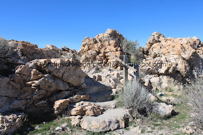
Heading into the rocks.
Random old staircase.
The lowest peak ever.
Trail split. Right leads up to the peak, left stays on the main trail. Both will get you to the end, right has a bit of a scramble. We went right today.
Bridger Bay again.
Short scramble up. It is still pretty easy though.
The peak. Like I said, this is the shortest peak ever. It is probably the easiest peak ever too.
View to the eastish.
Panoramic.
The peak again. It is 4348 feet in elevation according to the topographical map I use. The lake is currently at 4193 feet in elevation. That puts this peak at 155 feet above the lake, currently. That seems about right ish. But you know, I am not really good at judging height.
Random little rain/snow melt puddle. I don't know if they are as important here as they are in the desert, but probably.
Bridger Bay to the west.
Panoramic.
Now we just need to make our way back down to the main trail.
We found a way down that wasn’t too much of a scramble. I didn’t think to get a better picture of it. Whoops. But, if you can’t find one, it is not very long to go back the way you came to the previous trail split.
Ack! I almost stepped on this guy.
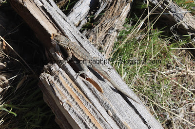
Hello cutey! Most lizards are quite.. skitsy. But this cute guy decided to hang out.
Then again, he seems to be munching on something.
Another lizard. These are likely side-blotched lizards, although I am not 100% sure.
Again.
Super old looking bench.
Bridger Bay.
Rocks.
Nearing the north tip of Ladyfinger Point and Egg Island in the background.
There is a bit of a web of trails out here, but every single one seemed to lead us to the same spot. So I think I found the end to the main trail eventually.
Looking out towards Egg Island again.
All the trails I have taken have led us to this, and it ended up being a quarter of a mile. So I think this is the official end of the trail. However, we have gone further, it just requires quite a bit of a scramble across the rocks down to the lake bed. It’s not super rough, but we have done it before so I decided we didn’t need to do it again today.
I believe that is Freemont Island to the northish.
The boulder field you have to scramble down to go further again. We decided to turn back. It’s a big island and we have so much more to explore!
The random spiral art has been mostly washed away.
The lake is quite mirror like today. It is stunning!
Egg Island again.
Bridger Bay and Buffalo Point. I didn’t realize it at the moment, but we ended up doing both of those today too. It's interesting what can happen when you don't really have a plan.
Another lizard.
Neat pair of split rocks before the little stairs.
The east one.
West one.
Top of the little stairs again.
Desert parsley.
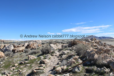
Lots and lots of rocks.
Looking back towards the peak.
More desert parsley.
Crow.
Heading back.
Looking towards the under construction Visitor Center.
To the east.
To the west.
Back to the parking lot.
I really enjoy this trail. Its short, its rocky, but it has nice views, and the shortest peak ever. We did not do the rocky scramble that we have done before, but I think we actually did the full intended trail this time haha. There were quite a few people, but not too bad. DR7 today.
As for difficulty, it is short, and easy, DR3. If you decide to do more rock scrambling, I think that would bump up to a DR4.
Dogs are allowed, leased. Please clean up after your furry friends.
.jpg)


.jpg)


.jpg)


.jpg)


No comments:
Post a Comment