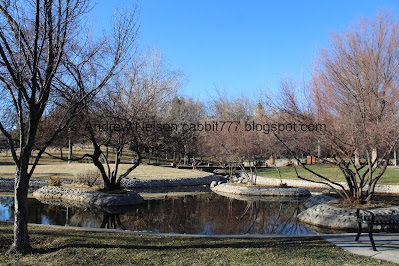
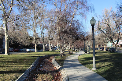
City Creek Park is a very small park located in Downtown Salt Lake City. It features a daylighted section of City Creek, some pretty trees including 2 sequoia trees! I don’t remember what prompted me to look up redwood trees in Utah, but I did, and I found quite a few! So that was our super nerdy scavenger hunt today.
Quick Details:
Length: The park itself is only about 2/10ths of a mile, but we added some extra along N Canyon Road, and ended up doing about 7/10ths of a mile out and back.
Trail Type: Loop, Connector, Out and Back option.
Difficulty: DR2. Its fairly flat and paved.
Elevation Gain: For the park itself not much. For the rest of the road about 75 feet.
Restroom: No. Closest public one I can think of is at the Capitol.
Dogs? Yes, Leashed. Please clean up after your furry friends.
Other Info: There is no dedicated parking lot, so you will need to park on the street. Pay attention to street signs to avoid a ticket.
To Get Here:
Take North Temple Street east. Take the first left after State Street on N. Canyon Road. The park will be on the left at the bottom of N Canyon Road. Find street parking.
Downtown from the freeway (Passenger Seat Photography (PSP)).
The new tallest building in Salt Lake City, The Astra Tower (PSP). Opened in 2024 it is 450 feet tall. It also has a light based system to forecast the air quality, similar to what the Walker Center Tower has for weather. One of these days I will be around it at night to see that too.
The Trail:
The park sign is carved into a boulder.
So, I learned that this park is the result of the cities first efforts to daylight some of our creeks. Our ancestors deemed our creeks to be a nuisance. After the great flood of 1983 they started to rethink that maybe channeling our creeks into culverts underground is not the best way to manage them. This short section of the creek was daylighted in 1995. Fun fact, City Creek was the first creek to be diverted into a culvert, and the first one to be daylighted. So that is super cool! The only other daylighted creek(s) I am aware of is the 3 creeks Confluence along the Jordan River.
The creek. We were parked near the north end, and decided to head towards the south end.
Upper bridge.
Small pond.
Again.
Like Memory Grove there are a few little embedded plaques in the ground showcasing local wildlife. We tend to see these up in the canyons on trails like Catherine Pass.
I believe the little 2X in the bottom corner means it was blown up to twice it’s size, which make sense since mice are small. I have seen mice on trails, but I could not tell you if it was a western harvest mouse or another species.
The pond again.
Sharp-shinned Hawk, with a spelling error. the shins are sharp, not the skin. The bird plaques kind of irked me. No footprints, feather prints or anything, just the name of it. Anyway, we have seen these in a few places, including our own backyard! They are kind of hard to tell apart from Cooper's hawks. I am never 100% sure which species I am looking at when I see them.
Raccoon. I have seen these in and around downtown, but have only caught a picture of them in my backyard (thankfully just once) and along the Mirror Lake Highway.
The pond again.
The lower bridge.
Upstream towards the park.
Downstream towards… whatever this is before the creek goes underground. Until it joins the Jordan River under North Temple.
We found our first sequoia! Hello friend. This is on the west side of the park, near the lower bridge.
As I am learning today, sequoias have a very uniform cone shape. Obviously the ones we found today are not, and likely will never be nearly as impressive as the ones found in The Redwoods, but it is still really freaking neat that there are several thriving species of them here in Salt Lake.
The pond again.
The lower bridge again.
The pond and the upper bridge.
The 2nd sequoia. This is also on the west side of the park, near the upper bridge.
Again.
Squirrel!
Adorable little beggar. Sorry guy, I didn’t bring anything for ya.
Ramp up towards State Street. If I had planned better today, that would have been a good option to get to our next adventure… but now that I am rethinking it, that would have required scurrying across State Street, which is really not a good idea, particularly on a steep hill like it is here. So, I am happy with the way we ended up doing things today.
The 2nd redwood again. The random site I found as my guide said a couple of trees here. I guess 2 counts as a couple, so I think that is all of them here.
A bunch of benches above the pond.
The upper bridge.
The pond, downstream.
The bridge again.
Upstream.
The pond again.
Well, that concludes the park section, which is about a 2/10th mile loop. Now we continued up N Canyon Road following City Creek some more.
City Creek just above 3rd Avenue. I am not sure if this part is technically part of the park or not, but I think probably. I am also unsure if it is part of the daylighted creek section. However, playing with google earth (which starts to get less clear back in the 90's) it looks as it it may have been, or at least was enhanced around the time the park was opened.
Deer mouse. Also double size. Again, I couldn’t tell you what mice we have seen.
Nice little green space along here.
Yellow -bellied Sapsucker.
I was just thinking wait, this is not a local woodpecker I am aware of… but now I see they are not local. I wonder how this one got mixed in here.
The creek again.
Golden-crowned kinglet. Again, the bird plaques are just kind of meh. I am sure I have seen these guys, but I am not great at identifying these tiny songbirds, so I can't say for sure.
Continuing along.
Crismon Mill Site historical marker.
Neat bridge.
Upstream.
Downstream.
Bobcat. I have not seen one of these in the wild, but I have seen one at Hogle Zoo. Like these footprints, it was smaller than I expected.
Oregon Junco.
Eh, I am pretty sure we have seen these from time to time as well.
Northern pocket gopher, also blown up 2 times. I see gopher mounds along our rivers, and have only caught some face and whisker before, so I think they are pretty cute. However, I have also seen their mounds and understand why people think they are a nuisance. I just wish they wouldn't use poison as it kills hawks and owls and other animals as secondary poisoning.
The creek again.
Uinta ground squirrel, also double size. Utahan's also refer to these as potguts. We see them fairly often in higher elevation places like the Albion Meadows.
I forget what kind of trees these are, but the street is lined with them. I am leaning towards sycamore, but am not 100% sure.
Starling. I have seen these guys in their full force along the Jordan River.
Rock squirrel. These are are pretty much everywhere in Utah.
The creek again.
Black-capped chickadee. These are pretty common, we see them in our backyard and many other places.
Interesting road bridge over 4th Avenue that looks a bit like a face.
Western meadowlark. I am fairly sure we have seen these guys around the valley.
The Fourth Avenue Well. This was highly opposed by residents, but they put it in anyway somewhere around 2020.
There is a quick crossing over 4th avenue, but it is not bad.
The back side of the well.
Here the trail switches to the east side.
Badger. Another animal I have not seen yet and would like to someday.
The creek again.
Townsend’s Solitaire.
Eh, I think we may have seen them but not sure.
The creek.
Brush mouse, also double size. Again, mice are cute and all, but I don't care enough to try to differentiate them.
The creek.
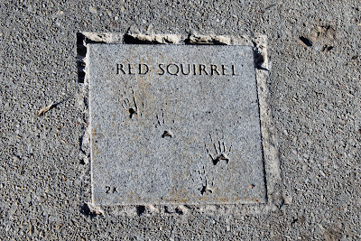
Red squirrel. I am not 100% sure, but I think that is what we saw today. We also see them all over the valley.
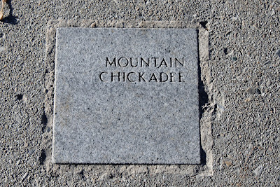
Mountain chickadee.
And we have hit the neighborhood below Memory Grove.
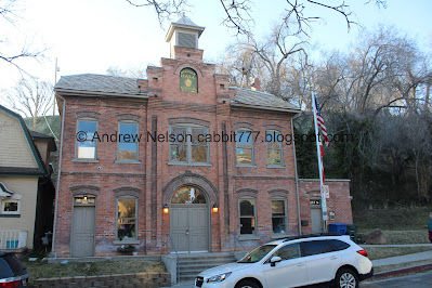
We decided to get a little closer to Ottinger Hall, since we have not been this close on foot before. There is a marked crosswalk just a but to the north of here.
Looking towards City Creek Canyon and Memory Grove. It is only another 1/10th of a mile up to Memory Grove. I kind of wished we had just done that today, cause I know the animal tracks continue up to the park. Meh, I guess next time.
Steller’s Jay. One of my absolute favorite birds that I generally find a bit higher in elevation in places like Lake Solitude.
Random boulder with hand prints.
It is a historic site. Built in 1900 it served as a social hall for volunteer firefighters. It's named for the state's first fire chief, George M. Ottinger.
Looking up. It is a neat old building.
I didn’t get a shot of the inside, because, well that just seems creepy, but it appears to be a classroom of some sort now.
I found an article that explains it was renovated in 2006 and YouthCity, an after school group for kids moved in.
We could have continued up to Memory Grove from here, but, we had some more stops on our random scavenger hunt, so we returned the way we came.
We missed a few of the wildlife markers on the way up. This one has been heavily damaged. We can see ukar, and well, I am pretty sure this one is for chukar. We have seen these in several places around the valley including the Jordan River.
Downstream.
The Fourth Avenue well again.
Crossing Fourth Avenue. There is a better crossing on the east side here.
The well house again.
Downstream.
441 Daffodils. 441 people died by gunfire in Utah in 2021. That… That is just not okay.
Down to the bridge.
Memorial marker.
White tailed jackrabbit.
Eh, I have seen a lot of rabbits, but I can’t say for sure this one.
Continuing down.
Flammulated owl. From what I can tell, they are super rare around here.
Bushy tailed woodrat. I have seen rats in the wild, a lot lately along the Jordan River, but I don't know if any of them were this specific species.
The creek again.
Looking back upstream.
Again.
Back down to City Creek Park.
Duck!
We returned to the car and I reviewed my list of places I had lined up to explore today and I realized the next closest place was just a bit uphill from here. As I said earlier, the ramp at the back of the park would have been a almost direct route, but with no protected crossing over State Street. That did not feel particularly safe, so we crossed State Street at the south corner, where there was a light. Point is, we left the car where it was and continued on foot, it was that close. Plus it allowed us to explore the far southwest corner of the park below the lower bridge.
The little pond again.
Panoramic.
Red-shafted flicker.
Or as I know them as, Northern flicker (red shafted for the ones out west). We get these guys in our yard and have seen them in such places as the Jordan River.
Ring-tailed cat. I only recently learned of these guys. Apparently they can be found down south in places like St. George. I would love to come across one one day.
Human. We see these things just about everywhere we go, and honestly they are more of a nuisance than anything. :-p But seriously, I am a little surprised there is not a ‘not to scale’ indicator for this one.
Looking back towards the lower bridge with the 3 archways from the southwest corner of the park. As I mentioned before, after here the creek goes underground not to be seen again until it enters the Jordan River.
That was a fun little adventure! I hit two birds with one stone in wanting to se more of City Creek, and wanting to see some redwoods. It was a little busy, but not too bad. Definitely not a bad little trail in the heart of downtown. Plus you can continue a little further, or a lot further up if you want. 9 out of 10 squirrels.
As for difficulty, it is all paved, and pretty flat. DR2.
Dogs are allowed, but should remain leashed at all times. Please clean up after your furry friends.
.jpg)









.jpg)


No comments:
Post a Comment