.jpg)
Fitts Park is a larger park in South Salt Lake that features the usual park things, such as playgrounds, fields, pavilions etc. It also features Mill Creek, and well, a couple other creeks as well. It looks like they are also building a bike path along the creek that goes through here. It is a fairly large and pretty park as well. So on the one hand, it was a great way to end our random scavenger hunt day, but on the other hand I would have liked some better lighting. Meh, we can always come back.

Quick Details:
Length: We did an about .85 mile loop with spur.
Trail Type: Loop with spur. Shorter loop option, out and back, connector.
Difficulty: It was super flat and paved. DR2.
Elevation Gain: NA
Restroom: No
Dogs? Yes, leashed.
Other Info:
To Get Here:
From i15 take the 33rd South exit heading east. Turn left on 5th East. The park will be on the left about 3/10ths of a mile later.
The Trail:

Okay, first of all, I absolutely love the vibrant colored bridges! Especially this purple one.

Green bridge.

I initially thought this was Mill Creek, but apparently, it is not.

After we crossed the green bridge.

Looking back at the purple bridge.
Both bridge appear to span a side creek called Spring Creek. I can track this south fork back up 2 blocks or so the the east, then, it’s gone. So it is either a split off of Mill Creek, or, like the name suggests, might come from a spring somewhere up there. There is a Spring View Drive up that way too though.

Here is Mill Creek, where it emerged from behind a few houses after a brief appearance at Kaleidoscope Park. Here it seems the creek has been left pretty wild compared to some previous sections that have ben channelized.

Mill Creek Pavilion.

Mill Creek again.

Yellow Bridge. I said I loved the colorful bridges right? Cause I really do.

The playground area, which is currently unoccupied. Landis asked what the high poles around it are, and I am pretty sure they are supports for shade tarps. Man, kids these days are so spoiled. When we were kids we just had to deal with the sunburns if we played on the playground too long.

The yellow bridge again.

Again. This leads to the far east end of Front Ave.

Park sign and rules.

Upstream.

Downstream.

Promise Bench. Aww, I think that is nice.

The promise Bench and matching bridge. From what I saw today, this is the only matching set in the park.

Flags to the north.

Well, they did not make this old bridge fancy. From what I saw today they still had 2 fun colors of the rainbow they could have used to zhuzh it up a bit.
Anyway, it leads to Front Ave. as well.

It looks like it used to be an automobile bridge, they added some fencing to make it a pedestrian bridge.

Spring Creek pavilion. This was the only piece of information that lead me to believe the side creek is Spring Creek.

Continuing west.

Another bridge they could have made fun with some color as well. This looks like the general standard bridges we see crossing most of our creeks around the valley. It crosses over Spring Creek before it enters Mill Creek.

Spring Creek joining Mill Creek to the left.

Spring Creek, upstream. Something seems to be splashing into it. We will come back to that.

Continuing west. Now I admit, I kind of just threw this list of adventures together for todays adventure, but I was not expecting the trail to keep going west here, so, this was a fun, unexpected addition. There is also an additional playground to the right.

Apparently, we are on a bike path here, but like all other city bike paths, it is shared use, so we are not in the way. However, I am curious to see how much further it goes each way.

Mill Creek again.

Again.

Continuing east, and starting to get a bit of a sunset.

Mill Creek again.

A 3rd playground. Wow kids have it good nowadays.

A big gaggle of ducks.

Mill Creek.

Big white duck.

Mill Creek flowing below 3rd East. As far as I can tell, currently, this is the last public area to see it before the Mill Creek Confluence along the Jordan River. Between here and there appears to be a large industrial area. However, this bike path seems pretty new, and might one day change that. I look forward to seeing what happens with it. Currently it appears to head north. It looks like the planned route is

Back into Fitts Park.

Mill Creek.

Again.

Big white duck.
Best answer I have found so far is that it is a domestic, pekin duck that either escaped captivity, or was released.

Mallards coming down to the creek.

Sunset.
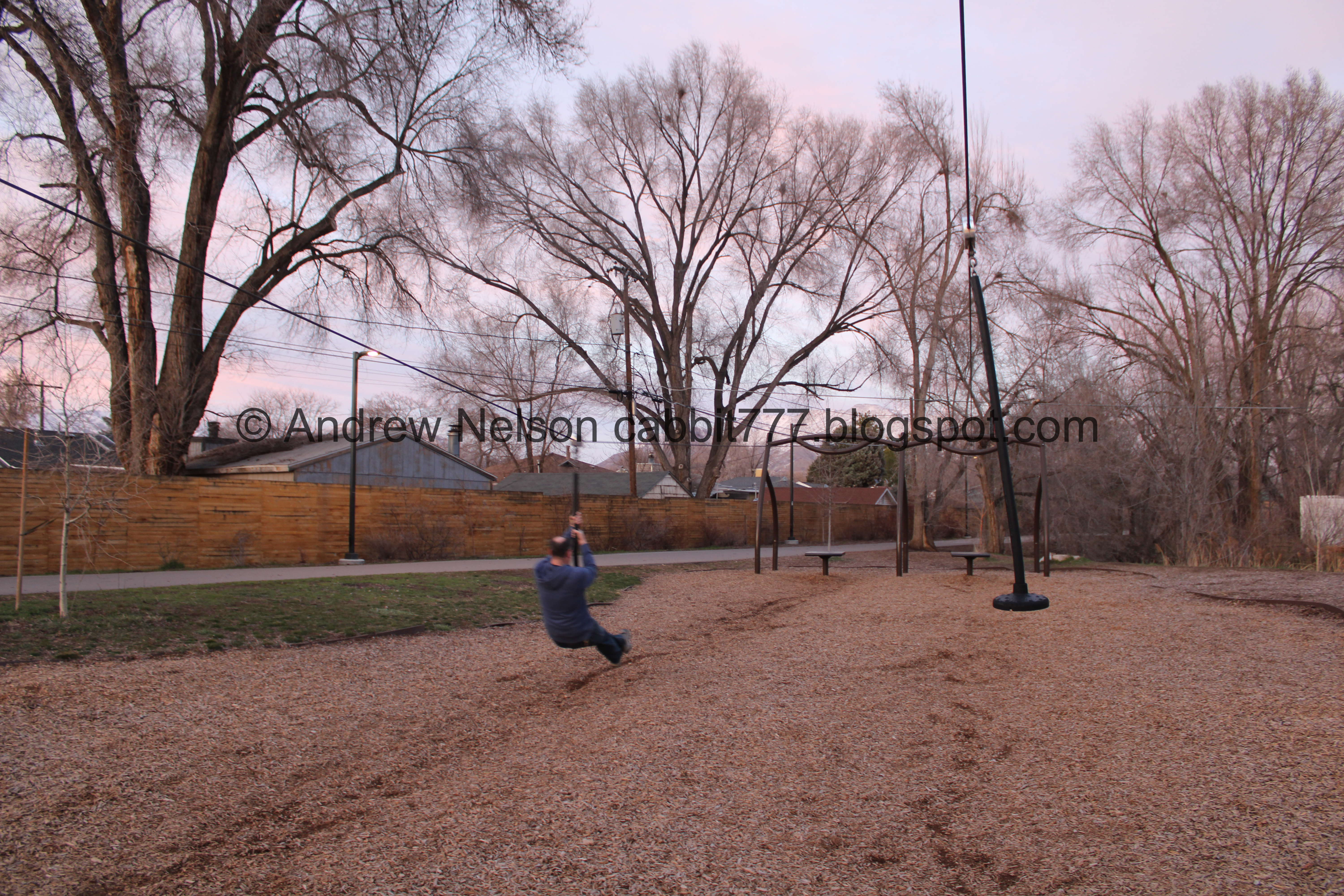
This park has freaking zip lines! None of the parks I grew up with had a zip line!
So seeing as there was no posted weight limit, or any other warnings we naturally decided to give it a go. It was fun. I liked a zip line I could do without triggering my fear of heights.

More sunset.

The creek again.

This weird course thing. It looks like a driving course, but a little smaller. Maybe it is to teach bike road safety habits?

The middle playground.

Continuing along.

Where Spring Creek joins Mill Creek.

Upstream Spring Creek.
Now we will complete the loop around Fitts Park.

More sunset.

Lots of water spraying out of this pipe.

Spring Creek.

Sunset.

Spring Creek again.

Fun blue bridge. This leads to Adams St.

South Salt Lake, Utah, and USA flags.

Sunset.

The blue bridge again.

Downstream.

Upstream.

Duckies.

There is another stream that connects here, or another fork anyway. I managed to trace this fork up to the pond in the Nibley Park Golf Course just northeast of here.

Another angle.

Another bridge they didn’t zhuzh up. This is across the south fork.

Duckies.

The first playground again.

Upstream along the south fork.

Gnarly old tree.
I didn’t get a picture of it, but there is a 4th pavilion here called the Lions Pride Pavilion. After this we decided to cut across the grass directly towards the purple bridge. There are 2 paved options as well, it just what my desire to see drove me to do today. Plus, while I am generally a stay on the designated trail kind of person, I feel like parks are kind of free game.

The creek again.

Approaching the purple bridge again.


More mallards. Most of the ducks have paired up for the season.

Sunset.

Mallards.

The purple bridge.

The purple bridge again.

Downstream, south fork of Spring Creek.

Upstream with the green bridge again.

Remains of the sunset.

The Wandamere pavilion.
We both wondered what Wandamere meant, and well, I found it was Utah's oldest amusement park that once stood where present day Nibley Park is. It was opened in 1864 as Calder Park (wow, it’s even older than Saltair). After some improvements were added it was changed to Wandamere, which loosely means Beautiful place, little lake. At the height of it’s popularity it saw over 100,000 visitors in a season. It changed hands a few times as interest waned, and was purchased by Charles Nibley in 1921, and then was donated to Salt Lake City on the condition that it always remain public space. It eventually became a 9-hole golf course that the city still operates. ABC4 Article (outside link)
There is a monument at Nibley Park that reads: “In the early 1860s George and Mary B. Calder built one of the first amusement parks on this spot. They cleared the land with oxen, planted grass and trees and converted a natural spring of water into a lake for boating. It was spanned by a picturesque bridge. A dance pavilion, racetrack, ball park, merry go round and other attractions were built. In the year 1909 it was improved and the name changed to Wandamere. After changing hands several times, Charles W. Nibley purchased the resort and presented it to Salt Lake City for recreational purposes.” SLCGolf Article (outside link).
Well that was a fun little bit of unexpected Salt Lake history. I might have to go down the rabbit hole on that some more someday.

Please do not feed the ducks and geese. South Salt Lake has chosen to just say no feeding them, rather than suggesting better food options like I have seen in other places. Like the Mehraban Wetland Park.
That was a neat park! It was equally good and bad that we saved it for last today. Good to end on a good note, bad that we did not have the best lighting today. But, it also was not busy, which is always nice. I also learned of a new, possibly growing bike path, and some unexpected history too. That was fun, 8 out of 10 squirrels.
As for difficulty, it is pretty flat and completely paved DR2. (we cheated a little and did cut across the grass near the end, but you don’t have to do that.
Dogs are allowed, leashed. Please clean up after your furry friends.

No comments:
Post a Comment