.jpg)
The West Willow Creek Trail in Draper is a short section of trail that follows Willow Creek on the west side of town. The trail features the creek, mountain views, and oddly today, some unexpected wildlife. The trail is currently split into 2 sections while they are working on Jenson Farm Park, then I imagine the 2 sections will be joined, and hopefully the trail will be extended even further. (one can hope right?)
Anyway, after Big Willow Canyon and Little Willow Canyon, the creeks combine and head through and below Draper City Park along the Willow Creek Trail. Then it flows through the city before flowing through here.

Quick Details:
Length: The north section is about 1.5 miles out and back. We ended up doing 2 miles out and back.
Trail Type: Little balloon, or out and back.
Difficulty: Both completed sections are paved and fairly flat DR2.
Elevation Gain: We did about 22 feet.
Restroom: Yes in the new Jenson Park Playground. I did not check if they were open.
Dogs? Yes, leashed. Please clean up after your furry friends.
Other Info:
To Get Here:
From i15 take 12300 South and head west. Go about 7/10ths of a mile, and turn right on 550 West. Go about 3/10ths of a mile turn right on 700 West. Go about 4/10ths of a mile and turn right on Rolling Hills Way. About 2/10ths the new playground will be on the right.
The Trail:

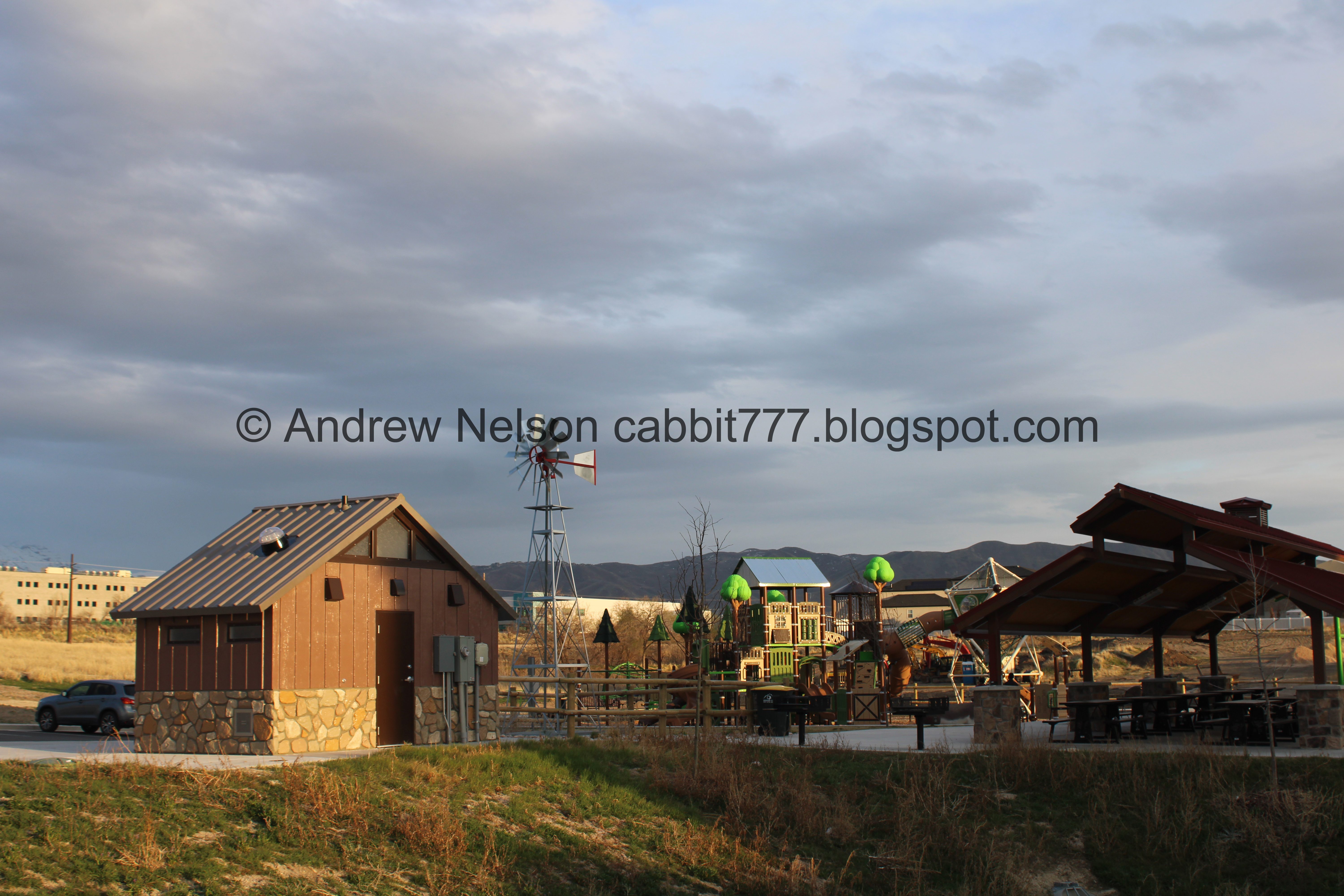
The new Jenson Park Playground looks fun. I know it is new, because it is not currently on google maps. I had planned to park on the road today, but was pleasantly surprised that there is now a parking lot to park in. From what I can find it was opened in August, 2024.

Random cow in the playground.

Willow Creek coming from the south. The city trails map shows this area is set aside as green space, but it looks like it is being developed? Maybe they are just developing more park area? I don’t know.
We decided to head north from here.

Where the creek flows under Rolling Hills Way.
The park again.

Park sign.

The trail picks up just to the northwest on the other side of Rolling Hills Way. There currently is no crosswalk, but its a quiet road so scampering across isn’t an issue.

They are definitely developing this part. Here is the giant pile of excess dirt.
We were hearing a very high pitch squeak that we couldn’t identify at first…

Then I spotted this marmot. I only recently learned that they are not necessarily high elevation dwellers, and that they have been seen down in the valley. But, this is the first one I have seen down in the valley myself. Fun! Like I said, I typically see them much higher up like near Catherine Pass high.

Like I said, I have generally associated these guys with high elevation, so while I normally recognize their squeak, I guess since we weren’t high elevation, my brain didn’t connect the dots until I spotted him. This alone made my day, and made me glad we came out to this one today. Here’s to hoping I randomly spot another marmot down in the valley someday.
Of course before I could pull out the telephoto, he was gone.

Little waterfall with discarded cement pieces.

Willow Creek.

Heading north.

The creek again.

Fun clouds.

The creek and old trees.

Dirt discard piles for the ongoing development.

The creek is a little hard to see through the phragmites in some places.

Continuing along. Eh, maybe I should have saved this for another day, it is getting a little dark.

The creek again.

Trees and clouds.

Gnarly nest. Likely a magpie nest.

I am not sure if this is beaver activity, or just a random catchment. Or, I guess it could be an analog beaver dam. I didn’t have the best view of it.

Hitting a more developed section.

Whoa. They have sure fancified this section.
We saw a sign that said Six Falls At Willow Creek. I guess it is a venue of some sort, but couldn't find any information on it. Also, what falls?

I guess the little cascades are the falls? Meh.

Mount Jordan. I imagine this view will soon be houses.

The creek.

Heading north.

The creek again.

This guy has added a little bridge.

I wonder why they have cut down most of the trees though here.

Duckies!

The creek.

Again.

Little cascade.

Last light on the mountains.

The creek again.

Trail split. It looks like the primary trail is to the right, so we went that way.

Little pond. It does not appear to have a name. I think it is a storm water pond of some sort.

Lone Canada goose watching the pond.

Fun colors of the faint sunset.

Reflection.

Couple of pairs of ducks on a little island.

Closer.

The north end of the pond.

Currently, the trail ends at 114th South. I hope they expand it some more. I guess we will just head back now.
From here, Willow Creek flows downstream through some neighborhoods, before entering what appears to be it’s possible original delta and marshland. It splits a few times before joining The Jordan River between 114th and 106th.

The little pond again. We decided to do the other side of it, since we know it joins the main trail again.

The short trail on the west side of the pond is not paved, but its flat and hard packed.

More removed trees.

Where the creek flows underneath 114th.

The pond.

The creek below.

Nice goosey…. nice goosey. Canada geese can be quite nasty, particularly this time of year.

Luckily it chose flight vs fight today. Phew!

Is that the nest??? Seems a little, haphazard. Also, why aren’t they sitting on the eggs, instead of just watching them? Weird. I did read that do do prefer a raised platform above water, so this makes sense, but still.

Again.

With mom.. or dad. I can’t determine sex with these guys.

Overflow spillway.

Where it flows into the creek.

Gloomy clouds sunset.

More duckies.

The creek, and more removed trees.
It just clicked in my brain why the trees were cut down. The new development above. Can’t say creek view if you can’t see the creek. Of course, that is just a guess.

The creek.

Heading back south.

More gloomy clouds.

Lots of phragmites.

Mount Timpanogos above Corner Canyon.

Mount Jordan.

The creek.

The waterfall.

The creek underneath Rolling Hills Way.

Ducks in the creek.

The creek though the development. This is the end of the current North Section and entering the incomplete Jenson Farm Park area. Since it is Sunday, there is definitely no work happening today, and with no ‘no trespassing’ or 'keep out' signs we decided to venture through. If the machines are running, I would avoid it though.

Lone Peak again.

The creek again.

Heavy machinery.

Gloomy skies.

Duck tracks.

Back to the pavement.

More clouds.

The creek below.

Duckies.

More development.

The end of the development. Looking at the south section. Here Landis decided he had enough, and well, I agreed, it was getting dark, and we were getting hungry, so we called it here. The south section of the trail is 1/2 mile, but only follows the creek for another 2/10ths of a mile or so. So I don’t think we missed much. However, I am willing to come back and check it out once the Jenson Park section is done.

The creek.

Possible spring.

I didn’t notice this pond on the way out.

Freight train.

The creek.

Again.

The developed section of the creek, and the recently completed playground again.

Mountains above.

The playground again.


I like the forest theme.

Neat little windmill. I’m not sure if it was repurposed from the old farm, or it is a replica.

Mount Jordan.
Meh, adding that up and coming Jenson Park area only added about a half mile out and back.
I really enjoyed the north section, actually. I guess seeing my first down in the valley marmot might have helped that though, but otherwise, it was kind of a nice creek between some neighborhoods. I imagine the Jenson Park section will be nice once it is complete. However if Big Bend Pond is any indication, that is years off. We didn’t do the south section, but it honestly does not seem very exciting. Meh, 6 out of 10 squirrels today.
As for difficulty, the north section is mostly paved, with a short loop part around a pond that is not, but it can be avoided, DR2. The south section is currently not paved, but probably will be eventually. DR3.
Dogs are allowed, but must remain leashed. Please clean up after your furry friends.
